Tagged: monochrome-photography
On Christmas Day in the Morning
25 Dec 2020
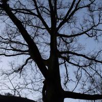
A Christmas Day walk with my friends Sarah and Vik, taking in the shipwrecked Shadow and a hilly chunk of Leigh Woods.
Saint Vincent's Spring
28 Dec 2020
Fractionally outside my one-mile zone, but I got curious about Saint Vincent's spring, whose last remnants you can see in a defunct drinking fountain on the Portway. Along the way I passed Gyston's cave, sometimes called St Vincent's cave, in the sheer wall of the gorge. It's now accessible by a tunnel from the observatory—I tried it about twenty years ago, I think, and still recall the vertiginous moment of looking down from the protruding balcony and realising that you could see straight through the grille floor to the drop below—but from what I can work out the tunnel is relatively recent. Before the tunnel was dug it was accessible only by access across the cliff face, which must have been even more terrifying.
This cave was first mentioned as being a chapel in the year AD 305 and excavations, in which Romano-British pottery has been found, have revealed that it has been both a holy place and a place of refuge at various times in its history.
A few different sources say that the cave became a hermitage and chapel to St Vincent following Bristol's early trading in Iberian wines; St Vincent of Saragossa is Lisbon's patron saint, and a lot of nearby things bear the name.
I'm not sure where the crossover of Vincent and Ghyston happens, though. On the giants Goram and Vincent (or Ghyston), Wikipedia says:
The name Vincent for one of the giants rests on the fact that at Clifton, at the narrowest point of the Avon Gorge, there was formerly an ancient hermitage and chapel dedicated to St Vincent, at or near the present cave in the cliff-face which bears his name. Another (apparently modern) version of the story calls the Clifton giant Ghyston, which is in fact the name, of obscure origin, for the whole of the cliff-face of the Avon Gorge at least as early as the mid-fifteenth century, in the detailed description of the Bristol area by William Worcestre. The place-name was personified to produce the giant's name. Vincent's Cave is called Ghyston cave or The Giant’s Hole in an article in the July 1837 issue of Felix Farley’s Bristol Journal.
In my research on the original Hot Well House, I've seen quite a few contemporary paintings which state their viewpoint as "from St. Vincent's Rock", so in the 16th century it seems the cliff-face name was typically St Vincent Rock rather than Ghyston's Rock, perhaps.
I am, as you can tell, no historian!
On the way, I also wandered around the base of the popular climbing area, which I think is the site of the old Black Rock quarry.
My historical research took a wander underground recently, partly inspired by the Canynge Square sinkhole, partly by St Vincent's (Ghyston's) cave and its tunnel to the Observatory, and I was surprised to find that there might be an intact tunnel from the Bristol Port Railway and Pier still just sitting there under Bridge Valley Road. A quick search turned up this recent video by an intrepid explorer, so it's definitely still there.
I went looking for the entrances today, and definitely found the south entrance, at the start of the Bridge Valley Path, the footpath that starts with steps at the bottom of Bridge Valley Road. It's easy to miss if you're not looking for it. I think I've figured out where the north entrance is, too, but it was getting dark at that stage and the Portway was still busy enough that crossing the road was still the normal nuisance, so I thought I'd leave further explorations for another day.
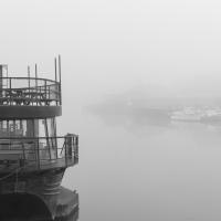
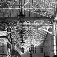
A Little Local Wander
07 Jan 2021
Which included a literal "local", the Pump House, to try out their shop/deli/cafe. A flat white, some apples and a New York Deli toastie. Eleven quid, mind, but the Pump House was never a cheap pub...
I enjoyed the fog, and wandering down a few more out-of-the-way back alleys and what-have-you on the Hotwell Road.
I'm thinking of getting up early and going for a morning walk tomorrow, weather-depending, but at the moment my motivation to do things like this seems to be much strong in the evenings when I'm just thinking about it rather than in the morning when I actually have to do it. But it's going to be cold, and low tide is quite early, so there's always a chance of getting some footage of the hot well actually being visibly hot; you never know...
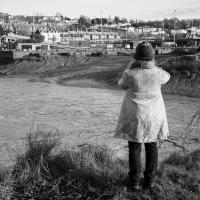
Morning Walk
08 Jan 2021
Tempted by a hopeful repeat of yesterday's weather, I got up early this morning and went for a short walk up into Clifton Village, around Observatory Hill, back down the Zig Zag and home. Instead of beautiful and mysterious fog and crisp freezing brightness I got some murk and slight dampness which included witnessing a road-raging van driver and finding that it still wasn't cold enough for the hot well to be even gently steaming when I got down there. I've still never seen it steaming, but I've been told it does, on colder days.
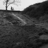
A Bristol tradition. Not quite sure what I was focusing on here, but it was early and dark and I quite like the picture anyway.
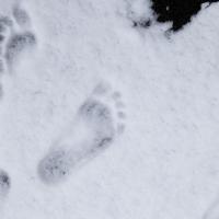
Snowy Leigh Wander
24 Jan 2021
I started this wander with my "support bubble" Sarah and Vik, after Sarah texted me to say "SNOW!" We parted ways on the towpath and I headed up into the bit of Leigh Woods that's not actually the woods—the village-like part in between Leigh Woods and Ashton Court, where I'd noticed on a map a church I'd not seen before. I found St Mary the Virgin and quite a few other things I'd never experienced, despite having walked nearby them many, many times over many years, including a castellated Victorian water tower that's been turned into a house...
In Between
06 Feb 2021
A lovely walk in the early spring sunshine with my friend Lisa. We headed directly for Jacobs Wells Road, to start off around the scene of one of our earlier walks, but this time took in Jacobs Wells from QEH upward, stopping to snap some photos of a Bear With Me, some interesting areas between Park Street and Brandon Hill including a peculiarly quiet enclave with a ruined old build I'd never found before, then crossed the Centre to grab take-away pies from Pieminister (I had the Heidi Pie) and head back to my place down the harbourside.
(Photographic Lack of) Worcester Terrace
09 Feb 2021
A nice walk, but something of a failure, photographically. I went to knock Worcester Terrace off my list, a not dissimilar terrace to Vyvyan Terrace, but one street further away from me. Like yesterday, it was very chilly but this time I went prepared with an extra layer and a winter coat. I think this may have been my downfall, as it may have been the X100T's control wheel brushing against the coat that put it in aperture priority mode at f/16, which I didn't notice at the time, and made most of my photos a little too blurry to use. Apparently in this mode, the X100 doesn't bump up the ISO if it can tell things might be a little too wobbly. Ah well.
So, a nice enough walk, and technically I did Worcester Terrace, but if you didn't take a photograph, were you really there? I'll have to go back...
Clifton Village, including Oxford Place
15 Feb 2021
I've noticed Oxford Place as a tiny little side/back road I've overlooked on my wanders a few times. Today I decided to pop down and have a look, as well as taking a few general snaps of Princess Victoria Street, which I thought deserved more pictures, as it's basically my closest decent shops, and in the Beforetimes I'd visit the Co-Op up there all the time, as well as the cafes (you'll be missed, Clifton Village branch of Boston Tea Party, recently closed in favour of Eat a Pitta.)
I'm definitely becoming more familiar with the area through the One Mile Matt jaunts and associated reading. Today I didn't just think, "oh, I'll head home down that weird alleyway with the electrical substation in it"—no, I thought, "I'll head home down Hanover Lane", because I actually knew its name. And on the way back from there I nodded sagely to myself as I passed St Vincent's Road, knowing now which St Vincent it's likely to be (St Vincent of Saragossa) and also eyed up the modern flats on Clifton Vale and wondered if they might have been built on the site of the former Vauxhall Pleasure Gardens... I don't know all the answers, but at least I have some idea of the historical questions I'm interested in.
I only had the little camera with me, so this is a bit pixelly as I had to "zoom and enhance" digitally.
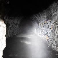
I'm glad my friend Lisa joined me today; she drove in from Shirehampton and told me that the Portway was looking rather lovely, so we set off that way. She's also braver than I am when it comes to doing urbex stuff, so this was just the opportunity to take a peek into the Portnalls Number One Railway Tunnel/Bridge Road Deep Valley Shelter whose entrance I'd found on a previous wander.
It was definitely dark and spooky and impressively big, with a side tunnel that Lisa explored that leads to a little door I don't think I've previously noticed on the side of the Portway. I didn't get many photos—even my astoundingly powerful little torch (£) didn't do much to light things up, and you're not going to get much joy hand-holding a camera in that darkness—but I did shoot a little video, which I might edit and add later.
After plumbing the bowels of the earth, we went up Bridge Valley Path to Clifton, explored some bits around the College and Pembroke Road, then came home via Foliage Cafe for coffee. Nice.