Tagged: building-material
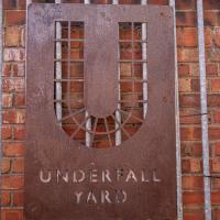
I'm afraid that this is a bit of a badly-curated wander, where I mostly just popped out to find out a little of the history of Underfall Yard and poke around the various open workshops, and, in hindsight, really didn't take pictures in any kind of coherent order. So there's a lot of pictures, but they don't really tell the story that, in hindsight, I seem to have been trying to tell, of the unusual electrical substation in Avon Crescent, the Bristol Electricity that predates the National Grid but is still in use, the history of the hydraulic power house... It's a bit of a mess.
But I suppose sometimes these wanders—always chronologically presented in the order I walked and took photos—simply will sometimes be a bit of a mess. Let's hope you still get something out of it, anyway...
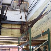
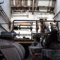
Most of the gear in this docks machine room is belt driven from a motor we'll see in a bit. The motor is electric but the drive system is pretty much the same as it was in the days of steam.
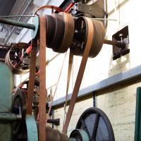
I guess the gearing is changed in the traditional way, by someone with a stick moving the belts across to the next diameters along. Apparently that used to be the emergency stop in the old days, too, some bloke poking at the belts with a pole until they fell off. Probably not ideal if it was to stop someone being sucked into the mechanism...
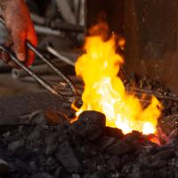
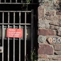
Apparently the "sparkies" are how you know the temperature's about right for the bonding-together of the link ends.
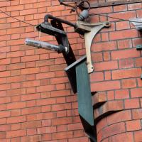
A little electrical detail on the Power House. Apparently it's not worked for some years, sadly.
Can you guess? Yes, the Power House was obviously something of a target during the war. It was strafed by the Luftwaffe at one point.
Fresh Fields
17 Oct 2021
For the first time in a while, I had the time and energy to go further afield and knock off some new roads from my "to do" list. I headed through the first Hotwells Festival to Ashton and Bedminster to cross off a few of the suburban roads south of North Street.
First, though, I decided to try to reproduce an old photo of the now-demolished Rownham Hotel just around the corner from where I live...
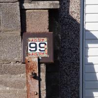
And I was right, the alleyway didn't really lead anywhere apart from people's garages and back gates, but at least 99 Smyth Road had a nice decorative number on the garage to look at.
I went out simply wanting to knock off the very last little unwalked section of Clanage Road, over by Bower Ashton, which has been annoying me for a while as it's quite close by and I've walked the other bits of it several times. So, my plan was to nip over to Greville Smyth Park via a slightly unusual route to wander Clanage Road and tick it off.
Along the way, though, I inevitably got a bit distracted. I took a few photos of Stork House, a grand Hotwell Road building that's recently been done up a bit (I imagine it's student lets, though I'm not sure) and which I found a reference to in a book about the Port Railway and Pier the other week, and also tried to match up a historical photo of Hotwells before the Cumberland Basin Flyover System laid it waste, which included some interesting markers I'll have to do a bit more digging into...
The more I research it, the more I find that Hotwells had far better transport links back in Victorian and Edwardian times than it has today. Along with buses that went to more useful places than the City Centre, there were trams, the funicular up to Clifton, the landing stage for paddle steamer services and two railway stations all within easy walking distance of me.
Today I took a day off work as preparation for doing the bookkeeping for my tax return1, and took a wander along to the site of what would have been my nearest station, Hotwells (or Clifton, as it started out in life), nestled in the shadow of the suspension bridge, the Bristol terminus of the Bristol Port Railway and Pier.
From there I wandered down the Portway, following the original line, until I got to the area around Sneyd Park Junction, where the tunnel from the slightly later Clifton Extension Railway joined up with this originally-isolated BPR line. Then I headed up to Clifton through the "goat gully" at Walcombe Slade, seeing the few above-ground bits of evidence of the tunnel (which is still in regular use) along the way.
It was a lovely day, and a good walk, and it was interesting to daydream of the times when I could have walked a few minutes from my flat down to Dowry Parade, caught a short tram ride to Hotwells Stations, and then headed from there to Avonmouth, perhaps even to board a transatlantic passenger service. The completion of the Clifton Extension Railway that linked the Avonmouth station with Temple Meads made relatively direct transatlantic travel from London via Bristol possible, with passengers travelling up from Paddington to Temple Meads, on to Avonmouth on the Clifton Extension Railway and Port Railway and Pier line, then perhaps catching a Cambpell's paddle steamer—which sometimes acted as tenders for large steamers—to a larger ship that was headed out for Canada, say.
1 I've learned that the best approach is to take two days off and deliberately do something that's not my bookkeeping on the first day, as otherwise I just inevitably end up procrastinating and feeling guilty on the first day no matter what. I have an odd brain, but at least I'm learning strategies for dealing with its strange ways as I get older...
2 Information mostly gleaned from Colin Maggs' The Bristol Port Railway & Pier and the Clifton Extension Railway, The Oakwood Press, 1975.
I didn't go inside, just shot through the gate with a steady hand. I have been in there, though, on one of the open day tours.
Yup, this is an access gate for the railway folk, presumably an easy route to this end of the tunnel. It's possible there's somewhere public to snap the tunnel from—there's a bridge further out of town toward Sea Mills, and there's a chance you could see the tunnel from there, but today's walk is already quite long enough, thank you.
From here the Clifton Extension Railway (from 1877) would have joined up with the line from Hotwells (completed twelve years earlier) at Sneyd Park Junction, a few hundred feet further out of town, and then proceeded to Sea Mills and beyond, terminating at Avonmouth. That bit of the line still runs; it's only the bit from Hotwells to here that was pulled up to make room for the Portway road, making Sneyd Park Junction no longer a junction.
Here a little fact I like: when the Bristol Port Railway ran out to Avonmouth from both Clifton Down station at the high far end of the tunnel near Whiteladies Road, and also from Hotwells, they offered a special splilt return ticket that let you walk down the hill from your home to Hotwells, take the train out to Avonmouth, then return to Clifton Down instead, so you could walk down the hill to home rather than walking back up. A lot of the dockworkers took this option, and it gladdens me to find that even these hardy folk were so put off by the hills of Bristol that they went for the lazy option!
Bower Ashton is an interesting little area just south of the river from me—in fact, the Rownham Ferry used to take people over from Hotwells to Bower Ashton, operating from at least the twelfth century to around the 1930s.
It's a strangely contradictory little area, with a cluster of old and new houses sandwiched in between the busy A-roads and significantly more industrial area of Ashton and the bucolic country estate of Ashton court roughly east to west, and also between Somerset and Bristol, north to south.
I've been around here before, mostly poking around Bower Ashton's arguably most well-known bit, the Arts faculty campus of the University of the West of England, but I'd missed at least Parklands Road and Blackmoors Lane, so I initially planned just to nip across briefly and wander down each in turn. On a whim, though, I texted my friends Sarah and Vik in case they were out and about, and ended up diverting to the Tobacco Factory Sunday market first, to grab a quick flat white with them, extending my journey a fair bit.
To start with, though, I nipped to a much more local destination, to see something that you can't actually see at all, the Gridiron...
(I also used this wander as a test of the cameras in my new phone. I finally upgraded after a few years, and the new one has extra, separate wide and telephoto lenses compared to the paltry single lens on my old phone. Gawd. I remember when speed-dial was the latest innovation in phones...)

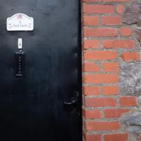
The whole little area here seems to be called Park Farm, and the area is marked as Park Farm on some fairly old maps. By the looks of it there certainly used to be a Park Farm here, but I don't know if any of it remains farmland or if it's all just residential now.
I think some of it, on the far side of these houses, is now the little estate where the Bristol Wood Project lives, where I once saw some pipers practising, and I suppose some of it may have been turned into the allotments, which would make sense for farmland...
The Gridiron and Bower Ashton Part Two
03 Dec 2021
On my last wander, to Bower Ashton, I was intending to knock Blackmoors Lane off my list "to-do" list, but got a bit diverted. I also took a little look into the history of the Gridiron, once a cheaper alternative to dry dock that was nestled just south of North Entrance Lock.
Today I had to go to send a parcel off somewhere, so I decided on going to the North Street Post Office via Blackmoors Lane. I didn't have much intention of anything else, but as luck would have it I walked out both at low tide and also as some lockkeepers seemed to be having a bit of a training session, and one of the more senior people was (a) happy to answer a few random questions on the Gridiron and (b) actually knew a lot about it, as Gridiron maintenance had been one of his jobs, more than twenty years ago...
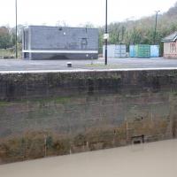
You can see how this sluice channel entrance in the side of the Entrance Lock wall is about level with the control wheel we saw on the far side—if you look closely, you can see it immediately to the left of and behind the modern building in the background. Given what the lockkeeper described to me, I'm confident that this is where the water for sluicing the Gridion clean of silt came from—they fill Entrance lock, then open the sluice to carry water—which must be under reasonable pressure with a full lock—across to the far side where the Gridiron is, washing off the accumulated silt.
Clever, these Bristol engineers: no actual pumping required. Just tides and gravity.
And that's the last of my musing on the Gridiron. I'm not sure why I became so fascinated by a giant Victorian boat-sieve, but I did!
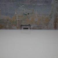
It seems I got back just in time to photograph this sluice channel in North Entrance Lock before it was covered by the rising tide (the outer gates were open.)
A Constitutional to Burwalls and Back
21 Dec 2021
The recent lack of posts here is mostly due to my feeling very run down following having a couple of wisdom teeth extracted. Having had an emergency appointment yesterday1, hopefully I'll be on the mend now, though it does mean I'm on the kind of antibiotics where you can't touch alcohol for the whole of the Christmas period. I have tried to keep myself a little distracted from the pain by working on the nuts and bolts of this website—you should notice that the front page loads rather faster now than it used to, and that there's a shiny new statistics page that I'll probably be continuing to work on. Oh, and you should find that the tags below the photos are now clickable and will take you to a page of all other wanders that have photos with the same tag.
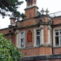
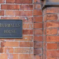
Today I felt like I needed to drag myself out of the house, but I didn't want to go too far, and I needed to get to the Post Office up in Clifton Village to post a Christmas card (spoiler for my parents: it's going to be late. Sorry.) As luck would have it, idly looking at the map I spotted that I'd missed off a section of Burwalls Road in the past, and that's basically one of the long-ways-round to Clifton Village, crossing the river to Rownham and walking up the hill on the Somerset side before coming back across the Suspension Bridge.
As I was heading for Burwalls Road I decided to make Burwalls itself the focal point of the walk, but unfortunately the mansion grounds are private and the place is hard to snap. Still, at least it gave me a destination. Burwalls was the mansion built by Bristol press magnate Joseph Leech, who I've mentioned before after buying a vintage book he wrote on a previous wander. There's a good article about the house on House and Heritage which has some photos from angles I couldn't ever get to. (Well, maybe with a drone, but it seems like the kind of area where they may be kitted out for clay pigeon shooting, so I probably wouldn't risk it.)
1 My dentist admitted that she probably needed to keep her internal monologue a bit more internal after we started the appointment with her staring into my mouth and immediately saying, "oh, *that's* weird." These are words one doesn't want to hear from a medical professional.
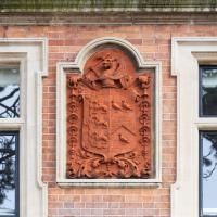
Joseph Leech doesn't appear to have had a coat of arms, and it's not the University of Bristol's (they were another former owner), but I struck lucky with my third guess: the Wills family crest apparently features three martlets around a chevron, as on the right, and three wyverns, as on the left... Can't find anything that's exactly like this one, but them I'm not exactly au fait with heraldry.
George Wills, of the Wills Tobacco family, was Burwalls' owner after Joseph Leech.
I was just about starting to feel better—the antibiotics seemed to have kicked in for my dental issues, and it had been some days since I'd left the house, and I was at last starting to get itchy feet. So, a wander. But where? Well, there were a few industrial bits near Winterstoke Road in the Ashton/Ashton Vale areas of Bristol that needed walking. I knew they were likely to be quite, well, unattractive, frankly. So why not do them while I wasn't feeling exactly 100% myself? Maybe it would fit my mood. Hopefully you're also in the mood for a bit of post-industrial wasteland, for that's what some of this feels like...
Then, at the last minute, I thought again about the Bristol International Exhibition—I've got a book about it on the way now—and that gave me another goal, which could just about be said to be in the same direction, and I decided to walk significantly further than my normal 1-mile limit and try recreating another historical photo...
Sadly I don't know much about the Ashton area; it's just on the edges of my mile and I rarely have cause to go there. It's brimming with history, I'm sure: the whole South Bristol area rapidly developed from farmland to coal mines to factories to its current interesting mixture of suburbs and industrial work over the last few hundred years. As a more working class area less attention was paid to it by historians, at least historically-speaking, than the Georgian heights of Clifton, and much of it has been knocked down and reinvented rather than listed and preserved. I see here and there some of this lack is being addressed, but I'm afraid I'll be very light on the history myself on this wander, as most of my usual sources aren't throwing up their normal reams of information as when I point them at Clifton, Hotwells or the old city.
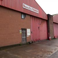
I do at least appreciate the fact that Bristol City Timber has a traditional wooden front door.
Near and Far
05 Jan 2022
I took advantage of a rare recent day where it wasn't tipping down with rain to get away from my desk on a lunchtime workday and head up to Clifton Village. I'd hoped to snap a reproduction of historical photo which I'd worked out had been taken from the Suspension Bridge, but the gods were not smiling on me. Still, taking only a nice long lens with me worked out very well as the lovely haze of the day made more distant views quite dramatic...
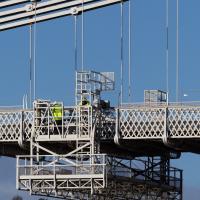
If I'd really considered it, the fact that there was a bloke in high vis standing on the bit of the bridge I wanted to take a photograph of might have warned me what was going to happen...
Lunchtime Cliftonwood Wander
18 Jan 2022
Another workday, another quick lunchtime trip to get me out of the house. This time my flimsy pretext is a tiny bit of Clifton Vale Close that I'd apparently not walked, and the fact that although I'd walked down Church Lane at least once before I still hadn't taken a single photo of it. Really I just fancied a mosey through Cliftonwood in the sunshine, with the promise of a coffee from Clifton Village at the top of the hill.
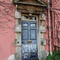
As promised, a bit more detail of the Amhurst door from the listing:
Left-of-centre doorway has Gibbs surround and thin consoles to a pediment, architrave with a split key, overlight with 4 pointed-arched panes and a 6-panel door, the upper ones raised.
Hopefully someone plans to give it a lick of paint at some point soon...