Tagged: geological-phenomenon
The more I research it, the more I find that Hotwells had far better transport links back in Victorian and Edwardian times than it has today. Along with buses that went to more useful places than the City Centre, there were trams, the funicular up to Clifton, the landing stage for paddle steamer services and two railway stations all within easy walking distance of me.
Today I took a day off work as preparation for doing the bookkeeping for my tax return1, and took a wander along to the site of what would have been my nearest station, Hotwells (or Clifton, as it started out in life), nestled in the shadow of the suspension bridge, the Bristol terminus of the Bristol Port Railway and Pier.
From there I wandered down the Portway, following the original line, until I got to the area around Sneyd Park Junction, where the tunnel from the slightly later Clifton Extension Railway joined up with this originally-isolated BPR line. Then I headed up to Clifton through the "goat gully" at Walcombe Slade, seeing the few above-ground bits of evidence of the tunnel (which is still in regular use) along the way.
It was a lovely day, and a good walk, and it was interesting to daydream of the times when I could have walked a few minutes from my flat down to Dowry Parade, caught a short tram ride to Hotwells Stations, and then headed from there to Avonmouth, perhaps even to board a transatlantic passenger service. The completion of the Clifton Extension Railway that linked the Avonmouth station with Temple Meads made relatively direct transatlantic travel from London via Bristol possible, with passengers travelling up from Paddington to Temple Meads, on to Avonmouth on the Clifton Extension Railway and Port Railway and Pier line, then perhaps catching a Cambpell's paddle steamer—which sometimes acted as tenders for large steamers—to a larger ship that was headed out for Canada, say.
1 I've learned that the best approach is to take two days off and deliberately do something that's not my bookkeeping on the first day, as otherwise I just inevitably end up procrastinating and feeling guilty on the first day no matter what. I have an odd brain, but at least I'm learning strategies for dealing with its strange ways as I get older...
2 Information mostly gleaned from Colin Maggs' The Bristol Port Railway & Pier and the Clifton Extension Railway, The Oakwood Press, 1975.
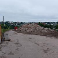
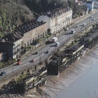
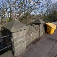
Here we see the Portway road, presumably fairly shiny and new, after many, many things, including the railway line from Hotwells to Sea Mills, were removed to make way for it. As you can see, they've done a splendid job of redeveloping the space where the station was into a little mini-park area, back in the day when the traffic wasn't a constant rush of noise and fumes and you didn't have to scamper across like you were playing a game of Frogger. It might well have been a pleasant place to sit. It certainly wouldn't be now.
Also, guess what there is fencing in the park area? Yes, some nice iron railings. I have no idea whether these are same ones I found—today's seem in surprisingly good nick considering this photo would have likely been taken almost a hundred years ago, and also how many railings were torn up during WWII.
This photo was taken before the war, as you can see a tram still running in the background—a Luftwaffe bomb took the tram system down in 1941 and it was never replaced. It also was obviously taken after 1926, as the Portway opened to traffic on 2 July 1926, having cost £800,000 to build, about £47m in today's money. So, that fixes it to a 15-year period, I think, but I'm not enough of a historian to be able to pin it down further.
From To Keep Open and Unenclosed, the Management of the Durdham Down Since 1861, Bristol Branch of the Historical Association, 2005:
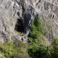
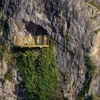
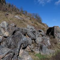
On the Avonmouth side of the Pembroke Road shaft two further shafts were made (one vertical to a ventilation turret in the Gulley and the other horizontal to an opening in the face of the Black Rock Quarry.
So, bearing in mind that this is Black Rock Quarry, I'd say there's a good chance this is the third, and least photogenic, ventilation shaft for the Clifton Extension Railway Tunnel. Later on in this wander we'll see the other two, which are rather prettier.
Bower Ashton is an interesting little area just south of the river from me—in fact, the Rownham Ferry used to take people over from Hotwells to Bower Ashton, operating from at least the twelfth century to around the 1930s.
It's a strangely contradictory little area, with a cluster of old and new houses sandwiched in between the busy A-roads and significantly more industrial area of Ashton and the bucolic country estate of Ashton court roughly east to west, and also between Somerset and Bristol, north to south.
I've been around here before, mostly poking around Bower Ashton's arguably most well-known bit, the Arts faculty campus of the University of the West of England, but I'd missed at least Parklands Road and Blackmoors Lane, so I initially planned just to nip across briefly and wander down each in turn. On a whim, though, I texted my friends Sarah and Vik in case they were out and about, and ended up diverting to the Tobacco Factory Sunday market first, to grab a quick flat white with them, extending my journey a fair bit.
To start with, though, I nipped to a much more local destination, to see something that you can't actually see at all, the Gridiron...
(I also used this wander as a test of the cameras in my new phone. I finally upgraded after a few years, and the new one has extra, separate wide and telephoto lenses compared to the paltry single lens on my old phone. Gawd. I remember when speed-dial was the latest innovation in phones...)
The Gridiron and Bower Ashton Part Two
03 Dec 2021
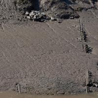
On my last wander, to Bower Ashton, I was intending to knock Blackmoors Lane off my list "to-do" list, but got a bit diverted. I also took a little look into the history of the Gridiron, once a cheaper alternative to dry dock that was nestled just south of North Entrance Lock.
Today I had to go to send a parcel off somewhere, so I decided on going to the North Street Post Office via Blackmoors Lane. I didn't have much intention of anything else, but as luck would have it I walked out both at low tide and also as some lockkeepers seemed to be having a bit of a training session, and one of the more senior people was (a) happy to answer a few random questions on the Gridiron and (b) actually knew a lot about it, as Gridiron maintenance had been one of his jobs, more than twenty years ago...
Yes, having compared it with old photos and the 1946 aerial view I posted on Sunday I'm sure that that's the end of the gridiron, all 200 feet of which is apparently still there beneath the silt.
The lockkeeper told me that the gridiron was in use as recently as 2000, and that it used to be his job to wash the silt build-up away, using a sluicing system we'll get to in a moment.
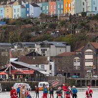
My friend Lisa texted me to see if I wanted to pop down and take a photo or two of the event she was taking part in: Santa SUP. SUP Bristol organise stand-up paddleboarding on the floating harbour, and their annual Santas-on-paddlboards event is quite the sight.
On the way there, I grabbed a historical photo I'd been wanting to recreate for a while of the shiny and new Cumberland Basin flyovers back in 1965, because I reckoned I could fit finding the same viewpoint into my outbound journey. Also, after having only used it on a wander for the very first time yesterday, I managed two crossings in the cross-harbour ferry today to get to the best locations for snapping the paddleboarders...
So, then, this wander is mostly a bunch of photos of paddleboarding Santas. Tis the season... Enjoy!
Lunchtime Reproduction (of an old photo...)
17 Jan 2022
This was basically the quick lunchtime jaunt I tried to do at the beginning of January, only this time I actually managed to get to roughly the viewpoint I'd been hoping for to recreate a historical photo of the Bristol International Exhibition.
I did this walk about a month ago, but I've been a bit poorly and not really up to doing much in my spare time, and it's taken me this long to even face processing even these few photos. Hopefully normal service will be resumed at some point and I can carry on trying to walk any roads and paths that I need to do to make this project feel complete...
The Colonnade, the Rock House, St Vincent's Parade and the old landing stages for Campbell's paddle steamers. The leftover fruit of bygone boom years.
There's a couple on the balcony taking a selfie in this direction. I wonder if I've been immortalised as a few pixels in the background of their photo...
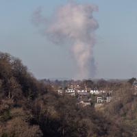
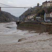
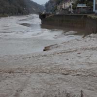
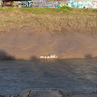
I think this may be the "avonmouth monster"; a plume of outflow from the works at Avonmouth. I took a photo of it some years back and asked BBC weatherman Ian Fergusson about it in the comments on this blog post—I'd recently done a tiny segment for his show "Wild Weather of the West" on how to photograph lightning—and that's what he said it was. This looks suspiciously similar and is in the right direction.
Bedminster Trip for New Walking Shoes
26 Feb 2022
I needed to buy new walking shoes—my old ones were squeaking and it was driving me up the wall—so I ordered some for collection from Taunton Leisure on East Street in Bedminster, and decided to make picking them up an official wander.
I didn't cover any new ground within my mile, but I did take advantage of the trip to take in a few interesting things just outside my normal radius, mostly New Gaol-related. Along the way there are a couple of sanitation-related diversions, including a visit to a rare manhole cover. You can hardly wait, I can tell!
Presumably this was the entrance to the stairs down to the ferry, long ago bricked up. There certainly seems to be a stairway behind it, though it's hard to tell for sure...
Leigh Woods Purple Path
12 Mar 2022
There's a few tracks in Leigh Woods that lie within my mile and show up on my map but that I've not walked yet, so I decided to take one of my traditional big long walks through the woods on this nice crisp sunny morning.
For years—decades, even—I've been doing a similar route from my place, along the towpath to the far woods entrance, up the hill for a varied walk on one of the marked tracks and then across the Suspension Bridge to Clifton Village for a coffee-based reward. It's my default "long walk", really, and I almost always enjoy it. Today, at last, spring actually seemed to be springing, which made for some extra positivity...
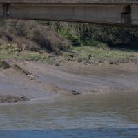
I mostly went out to hang out with my friends Sarah and Vik in Bedminster, but along the way I thought I'd take a closer look at something a little nearer home: the last crossing point of the Rownham Ferry.
There, hopefully you can see it now—the slipway of the last incarnation of the Rownham Ferry, in use from as early as the 12th century to 1932, when this particular slipway was last used.
There's not much to see at the moment, as the tide's a bit too high. I'm going to head over to the Tobacco Factory Market, meet some friends, do a crossword or two, and head back at lower tide.
Again, the slipway is easy to miss. I like these little barely-visible curiosities that hide such heritage. The site of the crossing moved around—it's fairly obvious it wasn't right here in the 12th century, for example, because the river was only diverted into the New Cut, which the ferry crosses here, in the early 1800s. Earlier it was further downstream.
At an earlier site, the ferry was mentioned in the Proceedings in the Court of the Star Chamber in the Reigns of Henry VII and Henry VIII after a dispute between a new competitor and the existing ferry, which was run by St Augustine's Abbey. Presumably the crossing was used to get to and from the abbey property at Abbots Pool, which I've actually swum in, from the Abbey, now Bristol Cathedral.
A Coffee and a Curve
27 Mar 2022
I wanted to have a wander along to the Tobacco Factory Market for some shopping, and checking the map for any leftover nearby streets I noticed a tiny curve of road on the way into the modern flats at Paxton Drive that it didn't look like I'd walked down before. I wouldn't take me too far out of my way, so I decided to head there first and then across to North Street to get my groceries and a coffee...
Work on the New Cut, this man-made diversion of the river to allow the harbour to float free of the tide, was officially started on 1st May 1804 and finished on 1st May 1809, with something of a party:
On 1 May 1809 the docks project was certified as complete and a celebratory dinner was held on Spike Island for a thousand of the navvies, navigational engineers who had worked on the construction, at which "two oxen, roasted whole, a proportionate weight of potatoes, and six hundredweight of plum pudding" were consumed, along with a gallon of strong beer for each man. When the beer ran out a mass brawl between English and Irish labourers turned into a riot which had to be suppressed by the press gang.
A Quick Swing Past Ashton Court
05 Jun 2022
Another day not dissimilar to my last wander: I'm feeling a bit tired and rather than just moping around the house I thought I'd find some tiny bit of somewhere that I'd not yet walked and get outdoors. This time I headed for the Tobacco Factory Market in Bedminster, as I often do, but went the long way around via Ashton Court Mansion as I knew there were some footpaths and a small section of road I'd not ticked off up there. Finishing all the Ashton Court footpaths will be quite a long job, but you've got to start somewhere...
I did feel rather better by the time I got home, and, pretty much astoundingly given the weather forecast, managed to avoid the rain completely.