Tagged: green
Leftovers with Lisa
01 May 2021
I didn't get to all the little leftover streets around the northeastern part of my area in today's wander, but I definitely knocked a few off the list, plus Lisa and I enjoyed the walk, and didn't get rained on too badly. We spotted the hotting-up of Wisteria season, checked out Birdcage Walk (both old and new), ventured onto the wrong side of the tracks1 and generally enjoyed the architecture.
1 Well, technically we probably shouldn't have been on the grounds of those retirement flats, but nobody started chasing us around the garden with a Zimmer frame

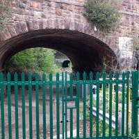
I've walked above these tracks many a time, but I've never been down on this level on this side of them—the other side is the pub next to the station, where I've been quite a few times...
Victoria Square Underpass
06 May 2021
I'm meant to be taking a little break from this project, but in my Victoria Square researches after my last walk I noticed a curiosity I wanted to investigate. The community layer on Know Your Place has a single photograph captioned, "The remains of an 'underpass' in Victoria Square".
Looking back through the maps, I could see that there really did used to be an underpass across what used to be Birdcage Walk. I can only guess that it was there to join the two halves of the square's private garden that used to be separated by tall railings that were taken away during WWII. Maybe it was a landscaping curiosity, maybe it was just to save them having to un-lock and re-lock two gates and risk mixing with the hoi polloi on the public path in the middle...
Anyway. Intrigued, I popped up to Clifton Village this lunchtime for a post-voting coffee, and on the way examined the remains of the underpass—still there, but only if you know what you're looking for, I'd say—and also visited a tiny little road with a cottage and a townhouse I'd never seen before, just off Clifton Hill, and got distracted by wandering the little garden with the war memorial in St Andrew's churchyard just because the gate happened to be open.
EDIT: Aha! Found this snippet when I was researching something completely different, of course. From the ever-helpful CHIS website:
When there were railings all round the garden and down the central path, in order that the children could play together in either garden there was a tunnel for them to go through. This was filled in during the 1970s but almost at the south east end of the path if one looks over the low wall the top of the arches can still be seen.
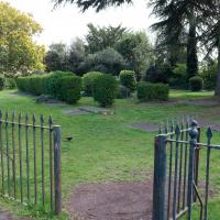
I'm going to call this the memorial garden. Don't know if it has an official name, but it's a railinged-off area with the war memorial in it...
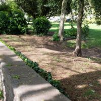
It's not glaringly obvious, but it does have the shape of an entrance to an underpass to me. I'd never really have noticed it walking past until I saw it on the map and decided to look more closely.
Coffee, Coronation and Clift House Road
28 May 2021
Another dash to Greville Smyth Park for a coffee from Rich at Hopper, but at least this time I managed to divert a bit and knock off a small section of Cumberland Road I'd managed to miss on previous excursions. Along the way I muse on a strange residence in between a warehouse and a tannery, and wonder if the Mayor might be deliberately letting the Cumberland Road Flyover area go to seed...

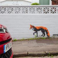
Bank Holiday Street Art
31 May 2021
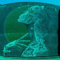
A nice warm Bank Holiday Monday saw me walk back over to Bedminster to do justice to something we glimpsed on my last wander. Along the way I spotted a couple of new pieces of street art tucked away on the south side of the Cumberland Basin Flyover system, so this turned into a micro-graffiti walk.
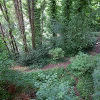
Leigh Woods Solo
19 Jun 2021
I hadn't really planned to go out for a wander yesterday; I just got the urge and thought "why not?" (Well, the weather forecast was one possible reason, but I managed to avoid the rain, luckily.)
I wanted to finish off the A369—as it turns out I may still have a small section to go, but I've now walked the bulk of it out to my one-mile radius—and also a few random tracks in Leigh Woods. I'm still not really sure that I'm going to walk them all, especially after discovering today that "the map is not the territory" applies even more in the woods, where one of the marked tracks on the map wasn't really that recognisable as a track in real life... I'm glad I'd programmed the route into the GPS in advance!
Anyway. A pleasant enough walk, oddly bookended, photographically at least, by unusual vehicles. Leigh Woods was fairly busy, especially the section I'd chosen, which was positively dripping with teenage schoolkids with rah accents muttering opprobrium about the Duke of Edinburgh. I'm presuming the harsh remarks were more about taking part in his award scheme than the late Consort himself, but I didn't eavesdrop enough to be certain...
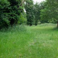
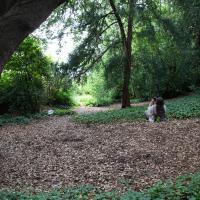
This was allegedly the path on Open Street Map that I used to plan my walk; I'm glad I had the GPS to tell me it was a path, because it barely looks like one.
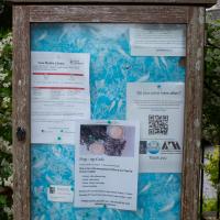
Long Ashton Parish Council, I'm assuming. I love a local noticeboard. Though the pop-up cafe sounds interesting, I don't think I've ever had a good coffee in a church. Clearly the devil has the best caffeinated drinks.
Shops, Hedgehogs and Cows
06 Jul 2021
I really only took the GPS and camera on a "just in case" basis, as I knew I was only going for a coffee in Greville Smyth Park along a well-trodden path this lunchtime. Still, I saw a few new things along the way, so I figured it was worth uploading the handful of photos I took...
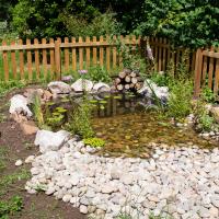
When I passed the (then-empty) fencing back in March I wondered what this would turn out to be. I had no idea it would be a miniature nature reserve...
According to the Friends Of Greville Smyth (FROGS!) Facebook page it's a hedgehog oasis, which is rather sweet.
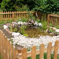
I see from the Facebook group that it was Rich from Hopper Coffee—the little coffee van I was visiting today—who first started the building of the pond, after finding dehydrated hedgehogs suffering in the park. It looks like it then became a group effort with several volunteers and donations of materials. Nice.
Lunchtime Zig Zag Climb
13 Jul 2021
A snappy little trip up the Zig Zag to the shops. It's a steep old route, the Zig Zag, going from just over river level to about the height of the suspension bridge (101 metres) in a compact switchback of a footpath.
I was too busy struggling to breathe to take many snaps of the actual Zig Zag (I've been trying to make it up all the way without stopping the last few times, but I've not quite managed it yet). I did at least take a few snaps either side on this quick lunchtime jaunt to fetch coffee (Coffee #1) and a sarnie (Parsons) from Clifton Village...
When climbing the Zig Zag it's helpful only to focus on where you are, rather than how far you've got left to go.
A Journey to the Far East
25 Jul 2021
The far east of the intersection of my one-mile radius and Bedminster, anyway. I was feeling a bit tired this morning, so I motivated myself to get out of the door by imagining one of Mokoko's almond croissants. That got me on my way, and I wandered across to Bedminster, through Greville Smyth Park, along most of the length of North Street (looking out for new Upfest 75-pieces-in-75-days artwork as I went) and then onto some new roads at the far end.
I only wanted to knock a few streets off my "to do" list, but by the time I'd diverted here and there to check out various bits of graffiti and other attractions and come back via the aforementioned purveyors of Bristol's finest croissants, I'd walked 7.4km. Not bad for someone who woke up tired, and at least I've done something with my day. I'm very glad the weather broke (we had tremendous thunderstorms yesterday), even if some of the pictures might've looked better with a blue sky. I was getting fed up with walking around in 29°C heat...
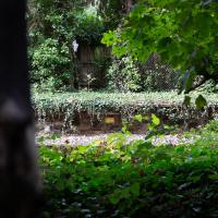
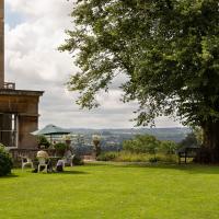
Green Squares and Secret Gardens
31 Jul 2021
At the end of July I went to have a look around some of the private gardens opened up by the annual Green Squares and Secret Gardens event. Sadly it was compressed into a single day this year, for various Covid-related reasons, it seems, so I didn't get to poke around too many places. I went to:
- A talk by the oldest resident of Victoria Square
- The St Vincent's Rocks Hotel garden
- The Paragon garden
- Cornwallis Crescent gardens, both east and west
- The Polygon garden
And snapped a few things in between, too. It was a lovely day—a bit too hot, if anything—and it was interesting to get into a few places I'd only ever seen from the outside, especially The Paragon and Cornwallis gardens, which are the least visible to passing strangers of all of them.
I recently indulged myself by buying a little piece of history. I've mentioned Samuel Loxton and featured and linked to his drawings before, often in the eminently browsable Loxton Collection albums that Bristol Libraries has on Flickr. So when I saw a Loxton drawing of Hotwells pop up on eBay, I decided to get myself a little treat.
I don't think there's any Loxton drawing that features the road I actually live in—it's not very visible from anywhere else, not being one of these Clifton terraces that's perched at the top of a hill, or anything like that, and it's invisible in most views of the area. However, this Loxton drawing, Hotwells, Looking across the river from near the Clifton Bridge station, is probably the closest near-miss I've seen.
I decided to wander out one morning and see if I could reproduce the picture, and also take a photo or two of what's now become of the Clifton Bridge Station, which is still just about discernible in places.
(Then on an even stranger whim I decided to check out a possible little cut-through from Cumberland Road to the harbourside I'd been eyeing up on my commute to work, so walked to Wapping Wharf for a croissant via this potential new route, but that bit's not quite as interesting...)