Tagged: history
I went out simply wanting to knock off the very last little unwalked section of Clanage Road, over by Bower Ashton, which has been annoying me for a while as it's quite close by and I've walked the other bits of it several times. So, my plan was to nip over to Greville Smyth Park via a slightly unusual route to wander Clanage Road and tick it off.
Along the way, though, I inevitably got a bit distracted. I took a few photos of Stork House, a grand Hotwell Road building that's recently been done up a bit (I imagine it's student lets, though I'm not sure) and which I found a reference to in a book about the Port Railway and Pier the other week, and also tried to match up a historical photo of Hotwells before the Cumberland Basin Flyover System laid it waste, which included some interesting markers I'll have to do a bit more digging into...
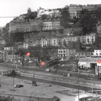
I found this image on Pinterest and as usual for that site it was annoyingly uncredited, but it seems to be from the book Hotwells, Spa to Pantomime, which I've just ordered direct from Bristol Books. Hopefully I'll be able to update the credit a bit when it arrives.
There's quite a lot in here that I didn't know about and will be researching a bit more, especially the Spa Assembly Rooms, which I think later turned into a school before being demolished for the flyover system, and also Anderson's workshop, a last vestige of the figurehead-carving industry.
Bower Ashton is an interesting little area just south of the river from me—in fact, the Rownham Ferry used to take people over from Hotwells to Bower Ashton, operating from at least the twelfth century to around the 1930s.
It's a strangely contradictory little area, with a cluster of old and new houses sandwiched in between the busy A-roads and significantly more industrial area of Ashton and the bucolic country estate of Ashton court roughly east to west, and also between Somerset and Bristol, north to south.
I've been around here before, mostly poking around Bower Ashton's arguably most well-known bit, the Arts faculty campus of the University of the West of England, but I'd missed at least Parklands Road and Blackmoors Lane, so I initially planned just to nip across briefly and wander down each in turn. On a whim, though, I texted my friends Sarah and Vik in case they were out and about, and ended up diverting to the Tobacco Factory Sunday market first, to grab a quick flat white with them, extending my journey a fair bit.
To start with, though, I nipped to a much more local destination, to see something that you can't actually see at all, the Gridiron...
(I also used this wander as a test of the cameras in my new phone. I finally upgraded after a few years, and the new one has extra, separate wide and telephoto lenses compared to the paltry single lens on my old phone. Gawd. I remember when speed-dial was the latest innovation in phones...)
I thought this was such an impressive sight I should pop an archive photo up in the wander for you to see.
Postcard from the Vaughan Collection/Bristol Archives.
The Gridiron and Bower Ashton Part Two
03 Dec 2021
On my last wander, to Bower Ashton, I was intending to knock Blackmoors Lane off my list "to-do" list, but got a bit diverted. I also took a little look into the history of the Gridiron, once a cheaper alternative to dry dock that was nestled just south of North Entrance Lock.
Today I had to go to send a parcel off somewhere, so I decided on going to the North Street Post Office via Blackmoors Lane. I didn't have much intention of anything else, but as luck would have it I walked out both at low tide and also as some lockkeepers seemed to be having a bit of a training session, and one of the more senior people was (a) happy to answer a few random questions on the Gridiron and (b) actually knew a lot about it, as Gridiron maintenance had been one of his jobs, more than twenty years ago...
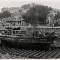
Here's the best photo of the Gridiron I've found so far: Item PG/3596 in the Isle of Man Photographic Archives.
The photo is dated 14 May 1946 and by amazing coincidence, looking at the boat's configuration and position, I think it may be exactly the same boat that's in the 1946 aerial photo from Sunday's wander.
Edit: later I found this colour picture of the Gridiron on Jem Southam’s Instagram feed, which was a lovely surprise!
I was just about starting to feel better—the antibiotics seemed to have kicked in for my dental issues, and it had been some days since I'd left the house, and I was at last starting to get itchy feet. So, a wander. But where? Well, there were a few industrial bits near Winterstoke Road in the Ashton/Ashton Vale areas of Bristol that needed walking. I knew they were likely to be quite, well, unattractive, frankly. So why not do them while I wasn't feeling exactly 100% myself? Maybe it would fit my mood. Hopefully you're also in the mood for a bit of post-industrial wasteland, for that's what some of this feels like...
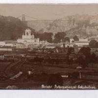
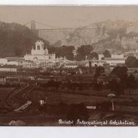
Then, at the last minute, I thought again about the Bristol International Exhibition—I've got a book about it on the way now—and that gave me another goal, which could just about be said to be in the same direction, and I decided to walk significantly further than my normal 1-mile limit and try recreating another historical photo...
Sadly I don't know much about the Ashton area; it's just on the edges of my mile and I rarely have cause to go there. It's brimming with history, I'm sure: the whole South Bristol area rapidly developed from farmland to coal mines to factories to its current interesting mixture of suburbs and industrial work over the last few hundred years. As a more working class area less attention was paid to it by historians, at least historically-speaking, than the Georgian heights of Clifton, and much of it has been knocked down and reinvented rather than listed and preserved. I see here and there some of this lack is being addressed, but I'm afraid I'll be very light on the history myself on this wander, as most of my usual sources aren't throwing up their normal reams of information as when I point them at Clifton, Hotwells or the old city.
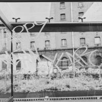
Here's the BBC report. This was posted on a telephone junction box in the "Daveside" area, the little strip of Festival Way that's used as a skate park in between the old railway depot and the White City allotments.
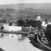
Source: Bristol Archives, Vaughan Collection.
Here we look, apparently from Bedminster Down, towards the "white city", the Bristol International Exhibition buildings of 1914.
This is the photo I've trooped all this way to reproduce. Have I managed to find the right spot?
A Random New Year's Day Wander
01 Jan 2022
I picked a fairly arbitrary reason for a wander today. Really, I just wanted to do a New Year's Day wander just to get out of the house and to set a precedent for the year to come.
My ostensible reason was to investigate what looked like a road on my map that quartered the lawn in front of the Ashton Court mansion. As it turned out, this is just a muddy footpath/desire line similar to a half-dozen other tracks nearby, and must be some kind of bug or misclassification with the mapping system I'm using, but that's not important. What's important is that I went for a little walk on the first day of the year. As a bonus, I did happen to wander down a couple of sections of new footpath, so technically I broke some new ground too, which is nice.
It didn't take long for someone to scrawl the sentiments of the season on a bus shelter.
Lunchtime Reproduction (of an old photo...)
17 Jan 2022
This was basically the quick lunchtime jaunt I tried to do at the beginning of January, only this time I actually managed to get to roughly the viewpoint I'd been hoping for to recreate a historical photo of the Bristol International Exhibition.
I did this walk about a month ago, but I've been a bit poorly and not really up to doing much in my spare time, and it's taken me this long to even face processing even these few photos. Hopefully normal service will be resumed at some point and I can carry on trying to walk any roads and paths that I need to do to make this project feel complete...
From Bristol's Lost City, by Clive Burlton, available from Bristol Books; photograph from the author's own collection.
(And extra credit goes to my parents for buying me the book for my birthday! Thanks!)
The Bristol International Exhibition site, presumably around 1914 or not long after. You can see the Rownham Ferry in use, too. I still find it pretty amazing that there used to be a busy ferry and a significant railway station on this little scrap of land that I just used to know as the grassy bit at the start of the towpath, let alone a replica of Bristol Castle!
Easter Monday Gardens and Flowers
18 Apr 2022
I didn't really set out with a theme of flowers and gardens in mind for this walk. I just fancied heading up to Clifton Village to get lunch. As it turned out, though, Spring was springing, so a minor theme emerged as I started off with the graveyard flowers of Hope Chapel and wandered up to see the beginnings of the new wildflower garden at Clifton Hill Meadow.
I first heard of Clerihews in the Times crossword: The Clerihew is:
a whimsical, four-line biographical poem invented by Edmund Clerihew Bentley.
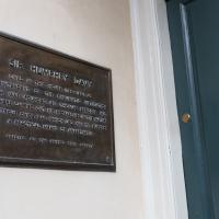
The reason it's relevant to this plaque on a house just around the corner from mine is that the very first Clerihew was written about Sir Humphry Davy:
Sir Humphry Davy
Abominated gravy.
He lived in the odium
Of having discovered sodium.
(Sir Humphry is indeed credited with having been the first to isolate sodium, six years after moving out of this house...)
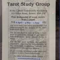
From the window of the community bookshop. A book I'm vaguely thinking of writing involves the Tarot, and I'm a little tempted to go on this.