Tagged: flowering-plant
Snowy Leigh Wander
24 Jan 2021
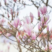
I started this wander with my "support bubble" Sarah and Vik, after Sarah texted me to say "SNOW!" We parted ways on the towpath and I headed up into the bit of Leigh Woods that's not actually the woods—the village-like part in between Leigh Woods and Ashton Court, where I'd noticed on a map a church I'd not seen before. I found St Mary the Virgin and quite a few other things I'd never experienced, despite having walked nearby them many, many times over many years, including a castellated Victorian water tower that's been turned into a house...
In Between
06 Feb 2021
A lovely walk in the early spring sunshine with my friend Lisa. We headed directly for Jacobs Wells Road, to start off around the scene of one of our earlier walks, but this time took in Jacobs Wells from QEH upward, stopping to snap some photos of a Bear With Me, some interesting areas between Park Street and Brandon Hill including a peculiarly quiet enclave with a ruined old build I'd never found before, then crossed the Centre to grab take-away pies from Pieminister (I had the Heidi Pie) and head back to my place down the harbourside.
Picture Postcards, Bikers and Wild Food
25 Feb 2021
I almost didn't bother bringing out my GPS today, but as it turned out I may have knocked off a tiny bit of Baltic Wharf, having been diverted through there on my way back from Imagine That café by finding Cumberland Road closed. Not sure whether it was just some kind of delivery to the roadworks there or if they're surfacing the increasingly-dodgy looking bit of the one lane that's left open...
I also snapped a picturesque view of Cliftonwood, hung out with a biker gang, and found a little something to nibble on growing on the Hotwell Road.
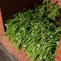
Even if you didn't know what it was on sight, you'd probably be able to tell from the smell...
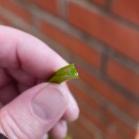
And just to confirm this is wild garlic, here's a stem. The Latin name is allium triquetrum, the three-cornered leek, because of its distinctive cross-section.
A Day Off Wander in Clifton
26 Feb 2021
I'm on the first day of a long weekend, and I certainly picked the right one for it. This may be the first proper spring-like day of the year in Bristol; it was glorious.
I headed up to Clifton, around the area where I got my Covid vaccine jab the other day, to knock off a few remaining roads in that area and because it would be good exercise for an extended lunchtime walk.
Along the way I saw some very Clifton sights, including an Aston Martin, some Jacobethan architecture, and some private college sports grounds. Mostly, though, I just enjoyed the sunshine, and took every opportunity I could to snap views across the city.
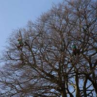
I say, there's men in that tree! Lots of pruning being done in the Paragon back garden today.
Clifton Down Dash
02 Mar 2021
A quick wander up to Clifton Village to wander down a path or two either around Observatory Road that I'd missed out previously. On the way around I took a moment to take in the incongruous 11 Windsor Terrace, smiled at a couple of mounted police, stopped to smell the crocuses, grabbed a coffee in Foliage and came home through the Polygon accompanied by the delightful Spring sound of a woodchipper running at full blast. Nice.
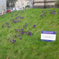
"The Crocus was chosen as the purple colour matched the dye painted on the fingers of children who have been immunised."
I'm still not entirely clear on how the crocuses are helping to eliminate polio, but the website's here...
Quick Around-the-Harbour Wander with Lisa
20 Mar 2021
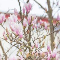
My friend Lisa was meeting another friend for a walk near the suspension bridge, so we fitted in a quick harbourside loop from my place first. We discussed gardening (we're both envious of the gardening skills of the Pooles Wharf residents; we can just about keep herbs alive, whereas they're growing heartily-fruiting lemon trees outdoors in England along with everything from bonsai to magnolias), cafes, work and architecture, among other things.
I bumped into my friend Lisa in town during yesterday's wander, and we decided to have a wander today, too. We managed quite a long ramble, starting up through Clifton and nipping down Park Row to investigate the two tower blocks I'd noticed popping up behind Park Street yesterday, then took in a few roads I'd not managed to get to before, including cutting through the grounds of Bristol Grammar School.
The gardens of Irving and Terry House were very well-kept, mostly container planting to soften the stark concrete of the place. Plant identification credit to my friend Sarah—neither Lisa nor I are that great at identifying plants, so I texted Sarah a picture :)

I noticed I'd missed a bit of Circular Road and Ladies Mile, and it was a nice evening for a sunset wander up to Clifton. There was something I recorded along the way, not photographically but in video.
Bristol Zoo, the world's oldest provincial zoo, has recently decided to close its Clifton site after 185 years of occupation, which means that the sounds of wild animals will no longer drift incongruously through this leafy Georgian area. They're moving everything up to their existing second site, The Wild Place Project near Cribbs Causeway. As I was wandering the Downs, I heard some fierce roaring noises, so I decided to see if I could get a little closer while they were still going on and record a sound that's soon to disappear.
I don't have a way yet to put video directly on this site, so here's a link to the video of my attempt to catch a bit of the zoo noises that I just popped on YouTube. It's sad that this might be the last time I hear such noises in Clifton.

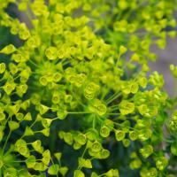
An araucaria, I reckon. I know the scientific name because there's a late great crossword setter who used it as a pseudonym, John Galbraith Graham.
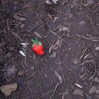
I was trying to find a way through to Observatory Hill via a different route from normal. Instead I found a corniche path with a somewhat vertiginous drop and... a strawberry. Presumably dropped from a picnic on the hill above...
A London Wander in Southville
10 Apr 2021
There's a bit of Southville that I've been meaning to get to for some time, where the streets seem to take some strong inspiration from London. There's a Camden Road that crosses with an Islington Road, and a Dalston Road, even an Edgeware Road. For me these names are more evocative than the rather more exotic names I passed by to get there—Sydney Row or Hanover Place, say, because I've actually been to the places in London. The last time I was in Islington I saw Monkey Swallows the Universe play at The Angel, and I can't think of Camden without remembering a gondola trip with my friend Tara where a cheery youth played Beatles music for us on a saz...
I really liked this little area, with its mostly well-kept pretty houses and hints here and there of the creative side of the residents. It's arty and down-to-earth at the same time, and I wouldn't mind living there, I think.
On the way there I got the chance to walk through Underfall Yard for the first time in a while, and on the way back I had my first take-away hot food for many months, grabbing some crispy fried squid from the excellent Woky Ko at Wapping Wharf.

Better Look at an Extension
14 Apr 2021
Apart from a lovely coffee and a slice of Victoria sponge from Twelve, there weren't any new sights on this little lunchtime jaunt except for a slightly better look at the long raised extension at the back of the St Vincent's Rocks Hotel, where I at least got to see the arches it's raised up on. I also got a fair bit of exercise by walking up the Zig Zag to get there, and saw far more people out than I have in months, what with the lockdown having just been significantly lifted. As I walked past The Mall pub they were turning people away from their already-full garden, and the (outdoor) cafe tables were pretty full up.