Tagged: hotwells
Nowhere New
10 Dec 2020
I didn't have any time to find a new place to go today, so I'm treading old ground here. I did buy a tub of duck food from Amazon last week and today I remembered to take a little bagful of it with me on my trip to Imagine That coffee, and spent a few minutes feeding the marina slipway ducks on the way back. This is a Bristol tradition I've seen other people doing many times, but never tried myself. It was quite genteel until the seagulls cottoned on, then it became something of a brawl.
Quick Hopper Coffee
11 Dec 2020
No new streets today—just out for a quick coffee from Hopper in Greville Smyth. Got caught in a bit of a rainstorm on the way out, but it didn't last long enough to bother me much.
Drained Basin
15 Dec 2020
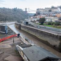
On the down side, I got to Bedminster and found long enough queues at both Mark's Bread and Hopper Coffee that I gave up on the idea of buying a drink and a pasty (from the former) or a mince pie flapjack (from the latter.) On the up side, I got to take some pictures of Cumberland Basin being drained and sluiced out, part of its regular maintenance cycle.
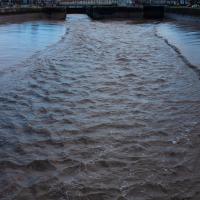
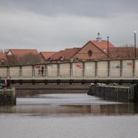
This is the next stage of the Cumberland Basin cleaning cycle. In the earlier pictures, you could see they'd emptied the basin. Now, with the Entrance Lock gates open, they sluice out the basin with an inrush of fresh water. This helps wash out accumulated silt and also freshens the water—it's usually done just before the occasional traithlon that takes place here, otherwise the swimmers would be even more at risk from E. Coli and other things than they are!
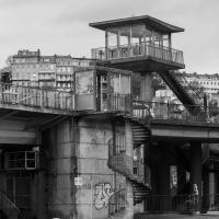
As a regular walker here, I just head for the spiral staircase up to the Plimsoll Bridge and cross that way if both lock gates are open (though of course you still have to wait if there's a bridge swing, too.) However, the spiral staircases are narrow, tall and annoying if you have to carry a bike. Here the cyclist is chatting to the lock operator, presumably finding out how long he might have to wait.
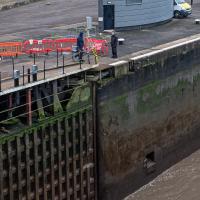
Just looking at this scares me a little. In an episode of Columbo featuring a flying instructor (I think), someone asks the scruffy detective if he's scared of heights. "I don't even like being this tall," he replies, and I can sympathise.
Coffee
18 Dec 2020
Another work lunchtime, another expedition to get coffee, but not down any new road. The walk around the haroubourside was nicer than usual, though, possibly because the day was dull and rainy, which stopped the most boring bit of the walk also being crowded.
The most boring bit of the walk is the bit where you can't go through Underfall Yard, closed due to Covid-19, so have to divert through Avon Crescent to the bit of Cumberland Road where there's just a narrow pavement next to a high wall on the one side, and the railings next to the river, where there's no pavement so you generally don't get close enough to it to see much. There would be another option, the Chocolate Path, if it hadn't fallen into the river last year, but the repair work following that landslip is currently making things even worse by forcing a stretch of Cumberland Road into a traffic-light-controlled single-lane system. This means that the narrow pavement is hard to escape as traffic could be coming past right next to you in either direction.
So, narrow, boring, plus it's not just my natural introversion that's causing me not to want to be forced into close contact with other people at the moment, of course. Maybe this will become my go-to coffee place on rainy days, just because there are fewer people on the streets.
Only a couple of photos today, and none of the boring bit, because I didn't know I was going to want to talk about it here until I got home!
To Bedminster
19 Dec 2020
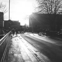
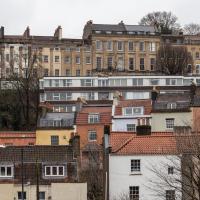
Despite a mild headache, I enjoyed this wander over to Bedminster. The light was lovely, especially toward the end. I always enjoy the view down the streets south of North Street at this time of day/year, with the distant hills backdropping the Victorian terraces.
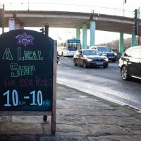
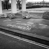
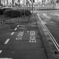
I have to think that if you need a specific parking place marked out for your signal engineer, it might be an indicator that your traffic lights aren't terribly reliable.
On Christmas Day in the Morning
25 Dec 2020
A Christmas Day walk with my friends Sarah and Vik, taking in the shipwrecked Shadow and a hilly chunk of Leigh Woods.
I went to have a peep at the giant sinkhole that's opened up in Canynge Square—ironically, having recently discovered the gardens were public I'd had the (triangular!) square on my list to re-visit for a few days, but now there's no entrance to the gardens due to the danger. The area was well fenced-off for safety, but I tried to get a couple of photos from behind the barriers.
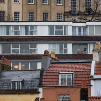
I also explored the area around Camp Road, an real melange of architectures, one of the most mixed-up areas I've seen in Clifton, in fact, and confirmed my friend Claire's suspicion that an earlier snap of a sign from Manilla Road was in fact for a fire hydrant. Nice.
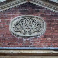
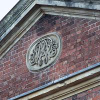
Historically, Albermarle Row was spelled "Albemarle", after George Monck, 1st Duke of Albemarle who was arrested and imprisoned in Bristol in 1642 when he refused to swear an oath supporting the Royalists during the Civil War. Most (but not all) of its street signs are now spelled "Albermarle", apparently after a mistake was perpetuated by a typo in a Council database a while back, and the spelling has spread to Google Maps and the Royal Mail database.
Other incorrect information on the internet about Albe(r)marle Row includes Historic England's listing, which says that this tympanum has "Webb's monogram with 1762."
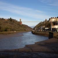
Saint Vincent's Spring
28 Dec 2020
Fractionally outside my one-mile zone, but I got curious about Saint Vincent's spring, whose last remnants you can see in a defunct drinking fountain on the Portway. Along the way I passed Gyston's cave, sometimes called St Vincent's cave, in the sheer wall of the gorge. It's now accessible by a tunnel from the observatory—I tried it about twenty years ago, I think, and still recall the vertiginous moment of looking down from the protruding balcony and realising that you could see straight through the grille floor to the drop below—but from what I can work out the tunnel is relatively recent. Before the tunnel was dug it was accessible only by access across the cliff face, which must have been even more terrifying.
This cave was first mentioned as being a chapel in the year AD 305 and excavations, in which Romano-British pottery has been found, have revealed that it has been both a holy place and a place of refuge at various times in its history.
A few different sources say that the cave became a hermitage and chapel to St Vincent following Bristol's early trading in Iberian wines; St Vincent of Saragossa is Lisbon's patron saint, and a lot of nearby things bear the name.
I'm not sure where the crossover of Vincent and Ghyston happens, though. On the giants Goram and Vincent (or Ghyston), Wikipedia says:
The name Vincent for one of the giants rests on the fact that at Clifton, at the narrowest point of the Avon Gorge, there was formerly an ancient hermitage and chapel dedicated to St Vincent, at or near the present cave in the cliff-face which bears his name. Another (apparently modern) version of the story calls the Clifton giant Ghyston, which is in fact the name, of obscure origin, for the whole of the cliff-face of the Avon Gorge at least as early as the mid-fifteenth century, in the detailed description of the Bristol area by William Worcestre. The place-name was personified to produce the giant's name. Vincent's Cave is called Ghyston cave or The Giant’s Hole in an article in the July 1837 issue of Felix Farley’s Bristol Journal.
In my research on the original Hot Well House, I've seen quite a few contemporary paintings which state their viewpoint as "from St. Vincent's Rock", so in the 16th century it seems the cliff-face name was typically St Vincent Rock rather than Ghyston's Rock, perhaps.
I am, as you can tell, no historian!
On the way, I also wandered around the base of the popular climbing area, which I think is the site of the old Black Rock quarry.
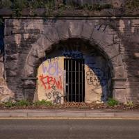
My historical research took a wander underground recently, partly inspired by the Canynge Square sinkhole, partly by St Vincent's (Ghyston's) cave and its tunnel to the Observatory, and I was surprised to find that there might be an intact tunnel from the Bristol Port Railway and Pier still just sitting there under Bridge Valley Road. A quick search turned up this recent video by an intrepid explorer, so it's definitely still there.
I went looking for the entrances today, and definitely found the south entrance, at the start of the Bridge Valley Path, the footpath that starts with steps at the bottom of Bridge Valley Road. It's easy to miss if you're not looking for it. I think I've figured out where the north entrance is, too, but it was getting dark at that stage and the Portway was still busy enough that crossing the road was still the normal nuisance, so I thought I'd leave further explorations for another day.
A Promenade on New Year's Day
01 Jan 2021
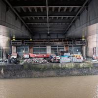
I wandered along the gorge today and found the entrance to the disused Portnalls Number 1 railway tunnel of the Bristol Port Railway and Pier. The door was unlocked, but as soon as I opened it I felt a sense of current habitation and decided discretion was the best option. There's a lot of people homeless in Bristol at the moment, and they don't need disturbing. For the same reason, I've omitted posting some pictures of a little encampment somewhat off the beaten track of the new Zig Zag, where I reversed direction as soon as I realised I'd come across a current habitation of some sort.
Up in Clifton it took me a little while to work out that the picture of the Promenade I was trying to reproduce was taken from the viewpoint I'd thought, it was just that the Alderman's fountain was moved from the top of Bridge Valley Road to the other side of the promenade in 1987, so trying to use it as my initial landmark wasn't very helpful!
Finally I swung past the Society of Merchant Venturers, who presumably still own most of Clifton, having bought the entire manor, including Clifton Down, in 1676, and I imagine aren't in much danger of running out of money. That's true to their motto: indocilis pauperiem pati is apparently from the Odes of Horace, and translates as "will not learn to endure poverty"...
The older signs in Bristol just say e.g. 8 instead of the full postcode district of BS8.
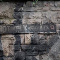
This sign, on the grotto that used to house the last remaining Hot Well pump, is the last Hotwell Road sign before it turns into the Portway. Which seems reasonable, as the Hotwell Road should obviously include the Hot Well...