Tagged: hotwells
A Coffee and a Curve
27 Mar 2022
I wanted to have a wander along to the Tobacco Factory Market for some shopping, and checking the map for any leftover nearby streets I noticed a tiny curve of road on the way into the modern flats at Paxton Drive that it didn't look like I'd walked down before. I wouldn't take me too far out of my way, so I decided to head there first and then across to North Street to get my groceries and a coffee...

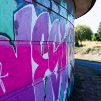
Looks more like a naughty-lus to me! We've seen another artistic nautilus before, on Park Row, by Lucas Antics, but this doesn't look like their style to my (entirely untrained!) eye.
I noticed I had a few things on my "potential wanders" list that could all be done relatively close to home, and in a fairly straight line, so I set off at lunchtime to recreate a photo of a now-defunct pub, wander behind a Spar (which turned out to be more interesting than I'd expected, but I admit it's a low bar) and spend some time browsing in Dreadnought Books before coming home via a coffee from Spoke & Stringer, a little diversion up Gasworks Lane and a tiny bit of the Rownham Mead estate I'd somehow previously skipped.
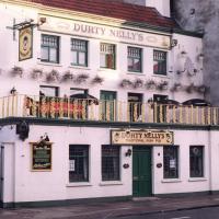
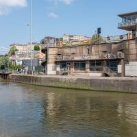
Uncredited apart from "from our archives" and undated, this photo appeared in this article on Hotwells in the Evening Post and made me want to re-create the same view today.
The pub had a few changes of name over time—in the Bristol Then and Now Facebook group people recall this being the Spring Gardens in the 1950s, 60s and 70s. Someone remembers it turning into Durty Nelly's in 1995, but I swear it was back to being the Spring Gardens again by the time I moved to the area in 1999. Then it spent some time as La Demi Lune, which you can see on Street View in 2008, and then by 2009 it's back to The Spring Garden (without the "s").
So, from what I can work out, this snap was probably taken in the 1990s, most likely between 1995 and 1999.
This pub—which did good food, and had an extensive garden at the back, from what I remember, when it was the Spring Gardens in the early 2000s—is rather more bland in looks today, as we'll see in the next picture.
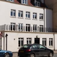
Here's the Spring Garden(s)/Durty Nelly's/La Demi Lune as it looks today. Rather dull modern accommodation, sadly. I understand they may have extended the building back into the garden to make it roomy enough to be flats.
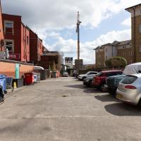
Here we are at the end of Pembroke Place, wandering a little alleyway I'd not previously filled in on the map. I didn't have high hopes for much of interest in this parking area behind Spar and Marcruss Stores. However, I did find something interesting, as we'll see in a couple of photos' time.
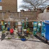
I can only guess that the Raj Bari restaurant has been trying to grow their own herbs and spices. Doesn't look that successful at the moment, to be honest, but maybe I'm looking at things that aren't in season...
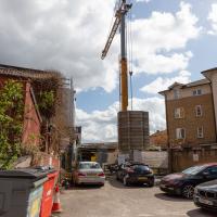
Not much to be seen in this direction except the crane on the site where they're busily filling a gap with new flats. We'll see the front in a little while.
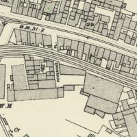
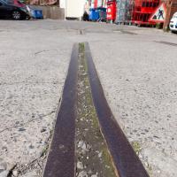
On Know Your Place you can check out old maps of Bristol. Sadly there doesn't seem to be an easy way of linking to a particular map/location. Still, here's a little screenshot of the 1898-1939 layer. These tracks are still there on the later 1949 map, so at least this section survived the war, I think.
Having checked Wikipedia I think this section, which ran from Canons Marsh to Ashton Avenue Bridge and then on to the south was created in 1906, and closed in 1965.
This map fragment will be © Ordnance Survey.
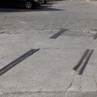
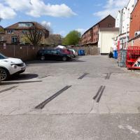
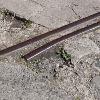
Remnants of the docks railway. These ran around the harbour to Ashton Avenue Bridge to the west, and along to the main Goods Depot at Anchor Lane to the east.
I think this may be the last visible remnant of the harbour railway on this entire stretch of the Hotwell Road. There may still be some tracks around Canons March—that whole area south of Anchor Road had a lot of rail lines—but I've not seen any others west of Jacobs Wells Road.
A Swing of the Plimsoll Bridge
24 Apr 2022
I was originally going to head over to the Ashton area to see if I'd missed any bits around the football stadium—and also to grab some lunch from the Tobacco Factory Market—but in the end I got a little distracted by having accidentally chosen exactly the right time to see the Plimsoll Bridge swing on one of the first busy days of Spring, where a lot of pleasure trips tend to head out down the Avon (and possibly the New Cut) from Hotwells.
In the end I mostly snapped that, and just a couple of photos from the Ashton area where I grabbed some lunch but didn't do any new exploring.
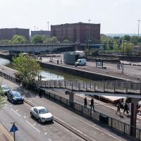
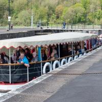
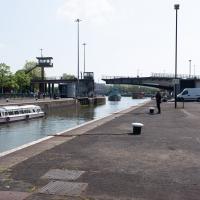
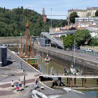
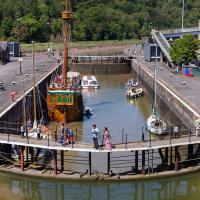
My first hint that there might be something interesting to look at was that the lock gates that I was planning on walking over were open rather than closed. Then I spotted the pleasure boat in the lock, just behind the descending steps from the footbridge there.
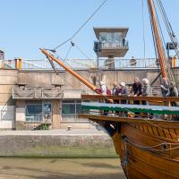
The Plimsoll Bridge is definitely not the oldest swinger in town. In fact, it may be the youngest swinger in town. I think the only other functioning swing bridges on the floating harbour (side-to-side rather than up-down like Redcliffe Bascule) are Junction Bridge (hidden in this picture, it's on the far side of the Cumberland Basin, carrying Merchants Road) and Prince Street Bridge, built in 1925 and 1879 respectively. The Plimsoll Bridge is mid-1960s.
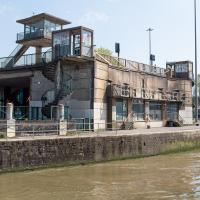
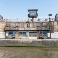
You don't often see this view of the brutalist bridge abutment, because the bridge itself is normally blocking and overshadowing the view here. Excuse me while I take far too many photos of it to be healthy.
I've always particularly liked the spiral staircases and the control tower, which looks like it's escaped from a prison camp.
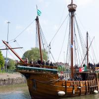
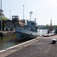
The brutalist bridge abutment is the old bit, of course, as it's mid-1960s. The boat that looks like John Cabot's 15th century caravel is the new bit. This replica was made in the 1990s, and replicated the original's 1497 trip to Newfoundland in 1997, arriving in June at Bonavista, to be greeted by Queen Elizabeth.
She's just had her annual inspection in the Albion dry dock, so I suppose this is one of her first gorge trips of the summer season.
You can see the man whose job it is to work the rather complicated-looking controls in the control tower has come out onto his balcony now the opening procedure is done.
Ticking Off a Pocket of Paths in Leigh Woods
03 Jun 2022
I managed to go for a wander a while ago that was meant to finish off a little tangle of paths in Leigh Woods, or at the very least finish off my wandering of the Purple Path there. And I managed to miss doing either of those things through some kind of navigational incompetence.
Today I woke up with a bit of a headache, feeling a bit knackered as soon as I dragged myself out of bed, but at least with the energy to realise that I'd be better off (a) going for a walk in what looked likely to be the last of the Jubilee weekend sunshine than (b) moping around the flat until it started raining, at which point I could mope more thoroughly.
I had a look at my map, considered going to Ashton Court, but remembered that there was a music festival there today, and instead found these little leftovers of Leigh Woods and decided to have one more try at walking them.
A Quick Swing Past Ashton Court
05 Jun 2022
Another day not dissimilar to my last wander: I'm feeling a bit tired and rather than just moping around the house I thought I'd find some tiny bit of somewhere that I'd not yet walked and get outdoors. This time I headed for the Tobacco Factory Market in Bedminster, as I often do, but went the long way around via Ashton Court Mansion as I knew there were some footpaths and a small section of road I'd not ticked off up there. Finishing all the Ashton Court footpaths will be quite a long job, but you've got to start somewhere...
I did feel rather better by the time I got home, and, pretty much astoundingly given the weather forecast, managed to avoid the rain completely.
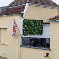
First hint of Jubilee-related decorations on this rather odd balcony at the bottom of Granby Hill. The other decoration on this building is a peeing "KEEP YOU JOB KEEP THE POUND" sticker in the next window along that looks like it dates from the 1990s.
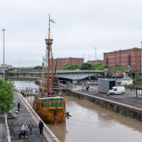
Fairly typical Bristol scene here, as the traffic is held up for a bridge swing caused by a replica of a 15th century caravel.
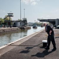
I'd normally walk over those open lock gates she's just sailed through, but it's easy enough to walk down to the gates at the river end.
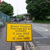
Ah, so it's the triathlon next weekend, then. The swimming bit is done in the Cumberland Basin, so I expect they'll be draining it and re-filling it with fresher water towards the end of the week. I wouldn't fancy it, even in a wetsuit.
I'm in the habit of going over to the Tobacco Factory Market on a Sunday. I think I've walked all the routes around that way, but as a Plimsoll Bridge swing let me cross the road to the far side of Brunel Way on my return journey and I took a couple of photos of the brownfield development at the old Ashton Gate Depot site I thought I'd call it a Wander and pop some photos up.
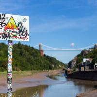
"STEEP DROP INTO MUD AND FAST FLOWING WATER".
This sign has been mildly annoying photographers since it was put up, getting a bit in the way of several alternative views from this bit of land. I presume it was installed in response to some kind of accident, but I'd hazard a guess that whatever difficulties someone got into probably wouldn't have been prevented by a sign that stated the completely bloody obvious.
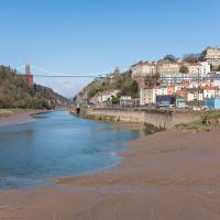
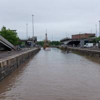
We start the day wandering around the periphery of the Cumberland Basin flyover system. Across Entrance Lock and then around the edge of Spike Island is my preferred route to get to Asthon Avenue Bridge and cross the river.
Ah, but it seems like the bridge is closing, which might make it nice and safe to cross over and have more of a look from the other side. First, though, we'll nip down and have a look at what's causing the swing.
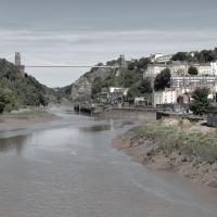
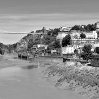
I took two shots from the south side of Brunel Way, a slightly different vantage point from my usual snapping point at the end of Spike Island down below. I'm not sure if I prefer this colour one...
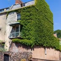
Well, technically that's Freeland Place, I suppose, but I was standing on Granby Hill to take the photo. I wonder how many photos of this fab house with its wrapping of Boston ivy I've taken over the years? I find it hard to resist on a nice clear day, especially if there aren't any cars parked on the hill and the ivy is in full effect.