Tagged: hotwells
Shiny New Hope
24 Sep 2021
A quick lunchtime jaunt to Clifton Village. Along the way I admired the new sign on Hope Chapel and added to my tsundoku collection.
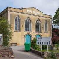
The scaffolding is down and there's a nice new sign (reminiscent of a historical one, I think,but I can't find the photo at the moment because Know Your Place Bristol is down) and you can just see the newly-installed solar panels on the roof behind it.
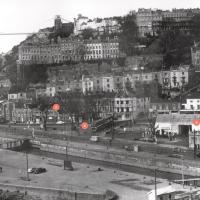
I recently indulged myself by buying a little piece of history. I've mentioned Samuel Loxton and featured and linked to his drawings before, often in the eminently browsable Loxton Collection albums that Bristol Libraries has on Flickr. So when I saw a Loxton drawing of Hotwells pop up on eBay, I decided to get myself a little treat.
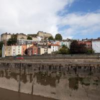
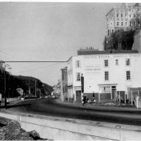
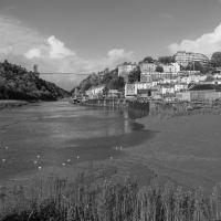
I don't think there's any Loxton drawing that features the road I actually live in—it's not very visible from anywhere else, not being one of these Clifton terraces that's perched at the top of a hill, or anything like that, and it's invisible in most views of the area. However, this Loxton drawing, Hotwells, Looking across the river from near the Clifton Bridge station, is probably the closest near-miss I've seen.
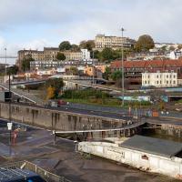
I decided to wander out one morning and see if I could reproduce the picture, and also take a photo or two of what's now become of the Clifton Bridge Station, which is still just about discernible in places.
(Then on an even stranger whim I decided to check out a possible little cut-through from Cumberland Road to the harbourside I'd been eyeing up on my commute to work, so walked to Wapping Wharf for a croissant via this potential new route, but that bit's not quite as interesting...)
I'd broadly planned to figure out the vantage point Loxton had used for his drawing by lining up Windsor Terrace with The Paragon, so I started taking bearings fairly early.
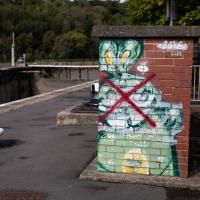
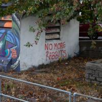
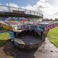
There's a frankly disturbing and gruesome reason why this rabbit has been crossed out. I'll tell you why in a few photos time.
This must be some kind of invasive species. Normally the inhabitants of this island are the apprently-native shopping trolleys.
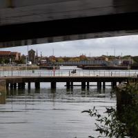
Every now and again some speedboat pops under Merchants Road Bridge and does a few quick loops of the Cumberland Basin. I guess that either they're allowed to go fast on the basin or they know they can get away with it...
Site of the Rownham Ferry. Follow the link for a charming Loxton ink drawing on Know Your Place, also viewable at the Bristol Libraries Flickr collection.
This was a later site for the ferry, which earlier was a tad further out along the river. It would have been a key crossing point at this end of Bristol before the arrival of any bridges near here. Before the Ashton Swing Bridge and the Vauxhall footbridge arrived, the next-nearest crossing point would have been the Vauxhall ferry, which was where Vauxhaull Bridge stands now, I think.
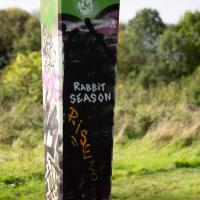
Okay, so here's the reason that the earlier rabbit had a big red cross through him, and that this one has been painted out. Bristol's graffiti community is currently trying to erase these rabbits after a terrible revelation about the man who had been painting them.
Here's the Bristol Post, on Damian Lasota, aka "Eldey" or "FollowMyRabbits":
A pervert with a penchant for grannies tried to rape one elderly woman in her home and sexually targeted another.
Damian Lasota was described by a judge as the "stuff of nightmares" after preying on the two lone females in Twerton, Bath.
His campaign of terror was halted after police installed CCTV at the women's homes and he was caught in action and arrested.
Lasota, 27, of Parry Close in Southdown, Bath, pleaded guilty to attempted rape, two charges of trespass with intent to commit a sex offence and two charges of exposure.
He appeared in the dock at Bristol Crown Court with a grey jumper draped over his head.
Judge Julian Lambert handed him a 20-year sentence, comprising of a 13-and-a-half year jail term and six-and-a-half years extended licence.
So, that's pretty damn terrifying, and also the reason why there won't be any more rabbits in Bristol. There's a little more info in this Somerset Live article.
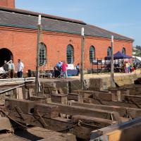
Docks Heritage Weekend Day One
09 Oct 2021
I could spend a lot of time at the Docks Heritage Weekend, poking my nose into industrial places along the harbourside that are usually closed off, but throw open their doors once a year to show off a bit of the backstage area of Bristol's floating harbour. In fact, I warn you: the next wander is a long one, and will have quite a few photos.
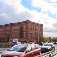
However, for today's wander, on the Saturday, my friend Lisa needed a shorter walk than our usual long rambles, as she's recovering from an operation and still a little under the weather, so we just wandered into town for some food and back, with me making mental notes of the places I wanted to come back to on the Sunday... We walked through Underfall Yard, along to the L Shed (this is the warehouse next to the M Shed museum, where they still have the kind of fun old industrial stuff that used to be crammed into the M Shed's predecessor, the old Industrial Museum), through the street food market in town to Ahh Toots for cake and then back home. So, still quite a walk, but no hills and not so much of Lisa having to hang around waiting for me to fool around taking photos as usual, at least...
The Patent Slip is actually a grade II listed building. Personally I live in a II*-graded building myself; not sure I'd want to slum it down here.
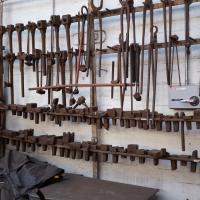
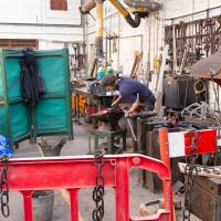
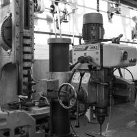
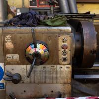
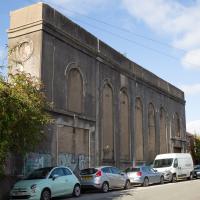
I'm afraid that this is a bit of a badly-curated wander, where I mostly just popped out to find out a little of the history of Underfall Yard and poke around the various open workshops, and, in hindsight, really didn't take pictures in any kind of coherent order. So there's a lot of pictures, but they don't really tell the story that, in hindsight, I seem to have been trying to tell, of the unusual electrical substation in Avon Crescent, the Bristol Electricity that predates the National Grid but is still in use, the history of the hydraulic power house... It's a bit of a mess.
But I suppose sometimes these wanders—always chronologically presented in the order I walked and took photos—simply will sometimes be a bit of a mess. Let's hope you still get something out of it, anyway...
It's very hard to get a decent look at this building. This is the top half of the back of it.
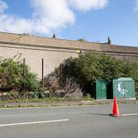
This building is, or was, an electrical substation. I heard an unconfirmed rumour that the building itself is now actually empty, and that the entire substation guts are now in these boxes. I have no idea whether that's true or not.
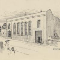
And here's the Loxton picture of the exterior, from the Bristol Libraries collection. Seems such a shame to have bricked up those lovely windows.
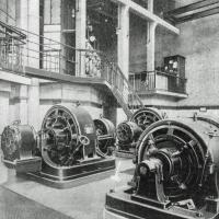
Via this Tweet and taken from KYP Bristol, showing the interior with a couple of Westinghouse rotary converters and a Peebles-La Cour motor converter, assuming this picture ties up roughly with this 1908 Institute of Mechanical Engineers' visit to works.
You can see a picture of similar Westinghouse converters to the two at the back in the Wikipedia rotary converter page and a Peebles converter that looks very similar to the one in the foreground on the cover of the Peebles motor converter catalogue in the sidebar of their entry in Grace's Guide. I'm guessing the additions on the ends of the Westinghouse converters were for different voltages? A rotary converter is basically a motor connected to a dynamo, so extra dynamos with different windings would give you different voltage outputs, I suppose, but I know very little about power generation.
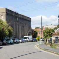
You can see this once apparently bright and airy building has had every window bricked up.
I understand that something in or around this building still supplies the odd electrical requirements (specifically, 360V "Bristol voltage") for some bits of Underfall Yard, which is our next stop, so more about that when we get there.
While it's not a listed building, is is notable: it's one of the earliest reinforced concrete buildings in the UK, apparently, construction starting in 1905. I assume it was up by 1907, as that's when Undefall Yard installed their electric pumps.
This oddity of history predates the National Grid and was originally fed from Feeder Road power station (well, Avonbank, on Feeder Road, to be precise. We've seen a bit of that history before, as a line marker for the line from Portishead to Feeder Road.) It was connected to Feeder Road by 1906, with a 6,600V line.
I've added a couple of historic views of the building as the next two photos in the wander, but I'll also pop this link to a Loxton drawing of the Avonbank electricity works, 1908 here.
Fresh Fields
17 Oct 2021
For the first time in a while, I had the time and energy to go further afield and knock off some new roads from my "to do" list. I headed through the first Hotwells Festival to Ashton and Bedminster to cross off a few of the suburban roads south of North Street.
First, though, I decided to try to reproduce an old photo of the now-demolished Rownham Hotel just around the corner from where I live...
Here's the view I wanted to take a stab at reproducing. Bristol's Lost Pubs—a great website, which sadly currently seems to be lost itself—said:
Originally known as the Hotwells Tavern. Around 1873 when the entrance to Cumberland Basin was enlarged, a pub named the Rownham Tavern was demolished and Rownham ferry moved downstream towards the Hotwells Tavern, not long afterwards the name was changed to the Rownham Hotel. The pub was removed in 1969 for road Widening.
This particular image is from Brewerypedia; I'm afraid I don't know its original provenance.

Here's my version. I couldn't get to the exact original viewpoint without the railings on the far left being in the way of the picture, but this is pretty close.
So, presumably the house (or possibly two?) on the end of Freeland Place, which looks to my eye just as Georgian as the rest of the terrace, must've been built after the Rownham Hotel was demolished for the road widening in 1969...
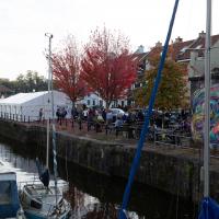
I wasn't in a particularly festive mood, so I decided mostly to bypass the Hotwells Festival. On a different day it might have been right up my street.

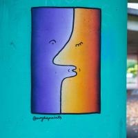
From @maybepaints, purveyor of "cheeky doodles round Bristol." It reminded me of this and by the looks of it that's by the same artist.
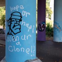
Well, presumably I'd be twice as happy, at least. Must tayk sum efurt 2 spell mor than haff ur wurds that badli.
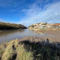
A Wide Angle View
30 Oct 2021
I had an unsuccessful wander last week, on Tuesday afternoon: my GPS died within about five minutes of leaving the house, and I didn't notice, plus I found hardly anything I'd been looking for. On the plus side, as I was wandering around Park Street I decided to nip into London Camera Exchange on the offchance they had a secondhand Canon 17-40mm lens. I've been thinking of buying one for around a year, I think.
Long story short: not only did they have one, but due to a mistake with their price labelling which they kindly honoured, I now have a shiny new (to me) wide-angle lens and it cost me less than £300, which is a very good price for one of these in good condition (and including a lens hood.)
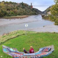
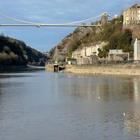
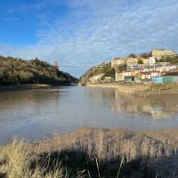
So, rather than try to salvage Tuesday's walk, here's a walk where I basically just bimbled up to Clifton Village for a coffee and wandered around taking photos of as many wide views as I could find. I took a lot more photos than these seventeen, but as you might expect, a new lens takes some practice getting used to, so most of them ended up in the "outtakes" pile.
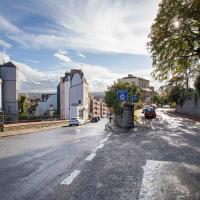
It's hard to snap this view, perhaps because nothing can convey the emotional context for me: the "nearly at home" feeling of wandering down from Clifton Village into Hotwells.
Ticking Off a Few Streets in Bedminster
31 Oct 2021
There were only a few streets left to wander in the more residential bit of Bedminster, so I thought I should target those today. The streets themselves weren't that notable, though Balfour Road has a contrasting mix of old and new housing. I tried to snap a few more interesting things along the way there and back, snapping all three of the familiar bond warehouses, nipping onto North Street to find some new street art, and finding a few pumpkins for good measure. It is hallowe'en, after all...
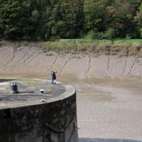
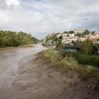
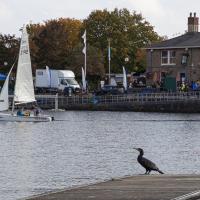
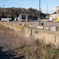
You can see the disturbance in the water on the river side as the sluices drain water from the lock to equalise the levels.
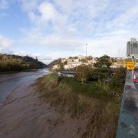
I went out simply wanting to knock off the very last little unwalked section of Clanage Road, over by Bower Ashton, which has been annoying me for a while as it's quite close by and I've walked the other bits of it several times. So, my plan was to nip over to Greville Smyth Park via a slightly unusual route to wander Clanage Road and tick it off.
Along the way, though, I inevitably got a bit distracted. I took a few photos of Stork House, a grand Hotwell Road building that's recently been done up a bit (I imagine it's student lets, though I'm not sure) and which I found a reference to in a book about the Port Railway and Pier the other week, and also tried to match up a historical photo of Hotwells before the Cumberland Basin Flyover System laid it waste, which included some interesting markers I'll have to do a bit more digging into...
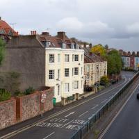
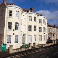
I've always loved the bow windows; if you look closely you'll see the window frames are slightly curved to match the curvature of the walls. Must be quite pricey to have repairs done, I'll wager.
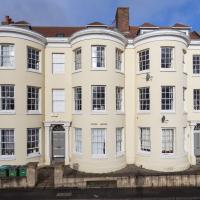
Stork House was the Stork Hotel back when the Bristol Port Railway and Pier, which connected Hotwells with a deep-water pier at Avonmouth, was in its heyday.
The Stork Family Hotel at Hotwells sought custom by advertising to seamen on ships arriving at Avonmouth, a combined rail ticket to Bristol and meal in this hotel. The same concern also advertised bed, breakfast, hot evening meal and seven days’ ticket to Avonmouth by BPR for sixteen shillings a week.
— Colin Maggs, The Bristol Port Railway & Pier, Oakwood Press, 1975
I imagine this would have been quite an attractive deal to a sailor, who could stay in Hotwells with its vast plethora of pubs and other entertainments and pop back to his ship in the comparative wastelands of Avonmouth when necessary. (There would also have been plenty of sailors who were already quite used to hanging around in Hotwells while their ship was in town rather than waiting around at the new pier at Avonmouth, and familiar with the local facilities. Thinking about what other "facilities" there may have been for sailors makes me wonder again if the bit of the Hotwell Road that ended up being called "Love Street" might've been a bit of euphemism at some stage or other...)
I found this image on Pinterest and as usual for that site it was annoyingly uncredited, but it seems to be from the book Hotwells, Spa to Pantomime, which I've just ordered direct from Bristol Books. Hopefully I'll be able to update the credit a bit when it arrives.
There's quite a lot in here that I didn't know about and will be researching a bit more, especially the Spa Assembly Rooms, which I think later turned into a school before being demolished for the flyover system, and also Anderson's workshop, a last vestige of the figurehead-carving industry.
I was trying to recreate the angle of the old, pre-Cumberland Road Flyover System photo that comes next. I couldn't get the angle, mostly because of the height, but this seems to be shot from about the right direction.
That historical photo seems to have been taken from a higher vantage point. The most likely place seems to be the B Bond, perhaps from that fire escape, or maybe the roof? Something tells me it's unlikely they'd let me up there, but you never know, maybe one day I'll ask an archivist; I think that area's part of the Bristol Archives stores...
The more I research it, the more I find that Hotwells had far better transport links back in Victorian and Edwardian times than it has today. Along with buses that went to more useful places than the City Centre, there were trams, the funicular up to Clifton, the landing stage for paddle steamer services and two railway stations all within easy walking distance of me.
Today I took a day off work as preparation for doing the bookkeeping for my tax return1, and took a wander along to the site of what would have been my nearest station, Hotwells (or Clifton, as it started out in life), nestled in the shadow of the suspension bridge, the Bristol terminus of the Bristol Port Railway and Pier.
From there I wandered down the Portway, following the original line, until I got to the area around Sneyd Park Junction, where the tunnel from the slightly later Clifton Extension Railway joined up with this originally-isolated BPR line. Then I headed up to Clifton through the "goat gully" at Walcombe Slade, seeing the few above-ground bits of evidence of the tunnel (which is still in regular use) along the way.
It was a lovely day, and a good walk, and it was interesting to daydream of the times when I could have walked a few minutes from my flat down to Dowry Parade, caught a short tram ride to Hotwells Stations, and then headed from there to Avonmouth, perhaps even to board a transatlantic passenger service. The completion of the Clifton Extension Railway that linked the Avonmouth station with Temple Meads made relatively direct transatlantic travel from London via Bristol possible, with passengers travelling up from Paddington to Temple Meads, on to Avonmouth on the Clifton Extension Railway and Port Railway and Pier line, then perhaps catching a Cambpell's paddle steamer—which sometimes acted as tenders for large steamers—to a larger ship that was headed out for Canada, say.
1 I've learned that the best approach is to take two days off and deliberately do something that's not my bookkeeping on the first day, as otherwise I just inevitably end up procrastinating and feeling guilty on the first day no matter what. I have an odd brain, but at least I'm learning strategies for dealing with its strange ways as I get older...
2 Information mostly gleaned from Colin Maggs' The Bristol Port Railway & Pier and the Clifton Extension Railway, The Oakwood Press, 1975.
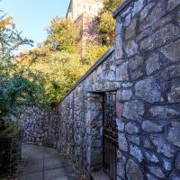
I'm pretty sure from looking at some maps that this is the gate that would have led to Prince's Lane, if it were still passable.
Bower Ashton is an interesting little area just south of the river from me—in fact, the Rownham Ferry used to take people over from Hotwells to Bower Ashton, operating from at least the twelfth century to around the 1930s.
It's a strangely contradictory little area, with a cluster of old and new houses sandwiched in between the busy A-roads and significantly more industrial area of Ashton and the bucolic country estate of Ashton court roughly east to west, and also between Somerset and Bristol, north to south.
I've been around here before, mostly poking around Bower Ashton's arguably most well-known bit, the Arts faculty campus of the University of the West of England, but I'd missed at least Parklands Road and Blackmoors Lane, so I initially planned just to nip across briefly and wander down each in turn. On a whim, though, I texted my friends Sarah and Vik in case they were out and about, and ended up diverting to the Tobacco Factory Sunday market first, to grab a quick flat white with them, extending my journey a fair bit.
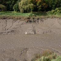
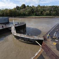
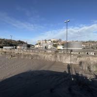
To start with, though, I nipped to a much more local destination, to see something that you can't actually see at all, the Gridiron...
(I also used this wander as a test of the cameras in my new phone. I finally upgraded after a few years, and the new one has extra, separate wide and telephoto lenses compared to the paltry single lens on my old phone. Gawd. I remember when speed-dial was the latest innovation in phones...)
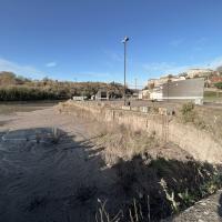
You can't actually see the Gridiron in this photo, but I believe it's still there, under that amazing buildup of silt.
The Gridiron—one of the few photos of it can be seen on the Maritime Mud and Miasma page of About Bristol—was a cheaper alternative to putting your boat in a dry dock. It was a 200-foot long grid (there seems to be some debate over whether the grid itself is actually metal, or in fact timber; I'll have to try to find out), 38 feet wide, nestled here between the north and south entrance locks. A ship captain could sail his vessel over here at high tide, then as the tide gradually receded, the ship—up to 250 feet, as overhanging a bit was apparently okay—would settle onto the gridiron.
At that point an inspection and repair crew could make their way down to the gridiron by ladder and do whatever work they could manage before the tide rose up again.
You can still see some ladders in place, I can only presume they were there to get you down to the gridiron, but that is just a guess; information on it seems quite hard to find.
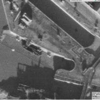
Image from 1946 Aerial layer of KYP Bristol/English Heritage.
As you can see, it was pretty big, and clearly still in use in 1946...
One last snap before we move on. I'm using the wide lens on the iPhone here, and have managed to include a silhouette selfie...
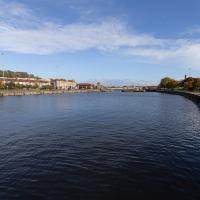
I decided to try out the three lenses on my new iPhone camera. This is the "telephoto" lens. It does a reasonably creditable job, though the phone is oversharpening things a bit and I'm not sure I like the colours much.
And here's the middling lens on the camera. Not bad, though on every shot I've taken on the iPhone so far where it's been able to see blue sky it's managed to oversaturate it for my tastes. Still, I guess they're aiming at the mass market, and the mass market does seem to like oversaturated colour and the sharpening turned up to eleven.
Not bad, and it's certainly better than not having a wide-angle lens in your pocket everywhere you go. I won't complain too much. "My iPhone oversaturates my photos. Also my wallet is too small for my fifties and my diamond shoes are pinching..."