Tagged: bank
Ticking Off a Few Streets in Bedminster
31 Oct 2021
There were only a few streets left to wander in the more residential bit of Bedminster, so I thought I should target those today. The streets themselves weren't that notable, though Balfour Road has a contrasting mix of old and new housing. I tried to snap a few more interesting things along the way there and back, snapping all three of the familiar bond warehouses, nipping onto North Street to find some new street art, and finding a few pumpkins for good measure. It is hallowe'en, after all...
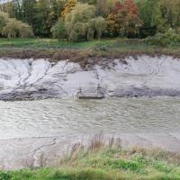
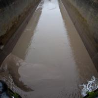
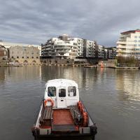
You can see the disturbance in the water on the river side as the sluices drain water from the lock to equalise the levels.
I went out simply wanting to knock off the very last little unwalked section of Clanage Road, over by Bower Ashton, which has been annoying me for a while as it's quite close by and I've walked the other bits of it several times. So, my plan was to nip over to Greville Smyth Park via a slightly unusual route to wander Clanage Road and tick it off.
Along the way, though, I inevitably got a bit distracted. I took a few photos of Stork House, a grand Hotwell Road building that's recently been done up a bit (I imagine it's student lets, though I'm not sure) and which I found a reference to in a book about the Port Railway and Pier the other week, and also tried to match up a historical photo of Hotwells before the Cumberland Basin Flyover System laid it waste, which included some interesting markers I'll have to do a bit more digging into...
It's surprising how much I forget is packed into this little area. There's the old station, the vast allotments, the cricket ground, the former police horse and dog unit, all the other stuff... Looking at Google Maps there may also be a day nursery and an escape room. It's a busy little area.
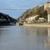
Former site of the Rownham Ferry, or one of them, at least. The ferry was there for centuries before being rendered obsolete by the Ashton Avenue Bridge, among others. King Charles allegedly crossed it in 1651, on his way to Leigh Court, but it was there for a long time before and after, closing in the 1930s.
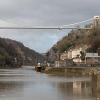
The more I research it, the more I find that Hotwells had far better transport links back in Victorian and Edwardian times than it has today. Along with buses that went to more useful places than the City Centre, there were trams, the funicular up to Clifton, the landing stage for paddle steamer services and two railway stations all within easy walking distance of me.
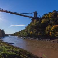
Today I took a day off work as preparation for doing the bookkeeping for my tax return1, and took a wander along to the site of what would have been my nearest station, Hotwells (or Clifton, as it started out in life), nestled in the shadow of the suspension bridge, the Bristol terminus of the Bristol Port Railway and Pier.
From there I wandered down the Portway, following the original line, until I got to the area around Sneyd Park Junction, where the tunnel from the slightly later Clifton Extension Railway joined up with this originally-isolated BPR line. Then I headed up to Clifton through the "goat gully" at Walcombe Slade, seeing the few above-ground bits of evidence of the tunnel (which is still in regular use) along the way.
It was a lovely day, and a good walk, and it was interesting to daydream of the times when I could have walked a few minutes from my flat down to Dowry Parade, caught a short tram ride to Hotwells Stations, and then headed from there to Avonmouth, perhaps even to board a transatlantic passenger service. The completion of the Clifton Extension Railway that linked the Avonmouth station with Temple Meads made relatively direct transatlantic travel from London via Bristol possible, with passengers travelling up from Paddington to Temple Meads, on to Avonmouth on the Clifton Extension Railway and Port Railway and Pier line, then perhaps catching a Cambpell's paddle steamer—which sometimes acted as tenders for large steamers—to a larger ship that was headed out for Canada, say.
1 I've learned that the best approach is to take two days off and deliberately do something that's not my bookkeeping on the first day, as otherwise I just inevitably end up procrastinating and feeling guilty on the first day no matter what. I have an odd brain, but at least I'm learning strategies for dealing with its strange ways as I get older...
2 Information mostly gleaned from Colin Maggs' The Bristol Port Railway & Pier and the Clifton Extension Railway, The Oakwood Press, 1975.
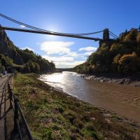
A last look back the way we came. Bristolians would have either walked to the station taken the tram; the tram rails ended just this side of the Gallery, from what I can make out from other pictures I've seen.
Here's one more interesting thing: it's just as well for me personally that the railway terminated in Hotwells. One of the original plans, which you can see in beautiful detail here, by clicking on the Community Layer pop-up in Know Your Place was for a tunnel under Clifton that would pop out about where Hotwells Primary School is and then run on to Temple Meads. Why would that be bad for me? Well, I reckon the tunnel would pass directly through my bathroom, bedroom and living room...
(That map, incidentally, by John Lavars, was popped on the Community Layer of KYP by my friend Dave. It's a shame that there doesn't seem to be a way to see who uploaded an item to the community layer, or see any more details about it...)
Bower Ashton is an interesting little area just south of the river from me—in fact, the Rownham Ferry used to take people over from Hotwells to Bower Ashton, operating from at least the twelfth century to around the 1930s.
It's a strangely contradictory little area, with a cluster of old and new houses sandwiched in between the busy A-roads and significantly more industrial area of Ashton and the bucolic country estate of Ashton court roughly east to west, and also between Somerset and Bristol, north to south.
I've been around here before, mostly poking around Bower Ashton's arguably most well-known bit, the Arts faculty campus of the University of the West of England, but I'd missed at least Parklands Road and Blackmoors Lane, so I initially planned just to nip across briefly and wander down each in turn. On a whim, though, I texted my friends Sarah and Vik in case they were out and about, and ended up diverting to the Tobacco Factory Sunday market first, to grab a quick flat white with them, extending my journey a fair bit.
To start with, though, I nipped to a much more local destination, to see something that you can't actually see at all, the Gridiron...
(I also used this wander as a test of the cameras in my new phone. I finally upgraded after a few years, and the new one has extra, separate wide and telephoto lenses compared to the paltry single lens on my old phone. Gawd. I remember when speed-dial was the latest innovation in phones...)
I decided to try out the three lenses on my new iPhone camera. This is the "telephoto" lens. It does a reasonably creditable job, though the phone is oversharpening things a bit and I'm not sure I like the colours much.
And here's the middling lens on the camera. Not bad, though on every shot I've taken on the iPhone so far where it's been able to see blue sky it's managed to oversaturate it for my tastes. Still, I guess they're aiming at the mass market, and the mass market does seem to like oversaturated colour and the sharpening turned up to eleven.
The Gridiron and Bower Ashton Part Two
03 Dec 2021
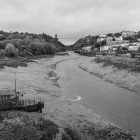
On my last wander, to Bower Ashton, I was intending to knock Blackmoors Lane off my list "to-do" list, but got a bit diverted. I also took a little look into the history of the Gridiron, once a cheaper alternative to dry dock that was nestled just south of North Entrance Lock.
Today I had to go to send a parcel off somewhere, so I decided on going to the North Street Post Office via Blackmoors Lane. I didn't have much intention of anything else, but as luck would have it I walked out both at low tide and also as some lockkeepers seemed to be having a bit of a training session, and one of the more senior people was (a) happy to answer a few random questions on the Gridiron and (b) actually knew a lot about it, as Gridiron maintenance had been one of his jobs, more than twenty years ago...
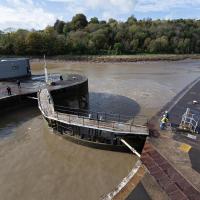
This used to be a view of the Gridiron, the structure I mentioned on yesterday's wander.
I got curious and went back to ask one of the lockkeepers about it. As it turned out, he knew lots about it as he'd previously been responsible for cleaning it! More about that when I come back (including a historical photo of a boat on the Gridiron for some context) as some of the things he told me needed me to retrace my steps for some more photos.
First, though, we'll nip over to Bower Ashton and North Streeet for a quick bit of shopping and to knock Blackmoors Lane of my "to do" list.
Yes, having compared it with old photos and the 1946 aerial view I posted on Sunday I'm sure that that's the end of the gridiron, all 200 feet of which is apparently still there beneath the silt.
The lockkeeper told me that the gridiron was in use as recently as 2000, and that it used to be his job to wash the silt build-up away, using a sluicing system we'll get to in a moment.
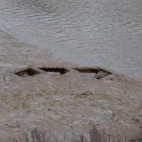
So, this is all that can be seen today of a 200-foot long, 38-foot wide grid of wood, I think—at first I figured it was metal, but Nick Howes posted a historic photo on Twitter where the grid itself certainly looks to be made of timber—hidden completely by a simple build-up of silt.
Up until the year 2000, it had been in use since some time in the 1890s, I think. Grace's guide's copy of the Institution of Civil Engineer's obituary of John McCurrich certainly attributes the construction of a gridiron to him while he was Docks Engineer for Bristol, and he held that post from 1890 until his death in 1899.
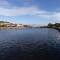
A Water-Based Wander
11 Dec 2021
I woke up on this Saturday with a headache, feeling like I'd not slept at all. As well as that, I'm still in some pain from the wisdom tooth extraction I had a few weeks ago. I moped about the flat for a while and then decided that the best thing to do was to force myself out on at least a small walk to get some fresh air and coffee.
Was there anywhere I could walk locally that I'd never been? Actually, yes! Although it's not a road, and I didn't walk it, there is actually one route that I've not travelled so far in my wanders. And it even had coffee near its far end...
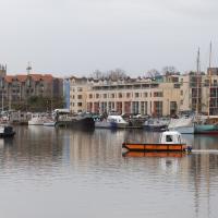
First, though, we'll take a poke around the Harbour Inlet. Here's Skyloom just pulling away from the pump-out station.
My friend Lisa texted me to see if I wanted to pop down and take a photo or two of the event she was taking part in: Santa SUP. SUP Bristol organise stand-up paddleboarding on the floating harbour, and their annual Santas-on-paddlboards event is quite the sight.
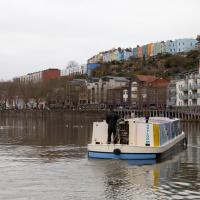
On the way there, I grabbed a historical photo I'd been wanting to recreate for a while of the shiny and new Cumberland Basin flyovers back in 1965, because I reckoned I could fit finding the same viewpoint into my outbound journey. Also, after having only used it on a wander for the very first time yesterday, I managed two crossings in the cross-harbour ferry today to get to the best locations for snapping the paddleboarders...
So, then, this wander is mostly a bunch of photos of paddleboarding Santas. Tis the season... Enjoy!
A Constitutional to Burwalls and Back
21 Dec 2021
The recent lack of posts here is mostly due to my feeling very run down following having a couple of wisdom teeth extracted. Having had an emergency appointment yesterday1, hopefully I'll be on the mend now, though it does mean I'm on the kind of antibiotics where you can't touch alcohol for the whole of the Christmas period. I have tried to keep myself a little distracted from the pain by working on the nuts and bolts of this website—you should notice that the front page loads rather faster now than it used to, and that there's a shiny new statistics page that I'll probably be continuing to work on. Oh, and you should find that the tags below the photos are now clickable and will take you to a page of all other wanders that have photos with the same tag.
Today I felt like I needed to drag myself out of the house, but I didn't want to go too far, and I needed to get to the Post Office up in Clifton Village to post a Christmas card (spoiler for my parents: it's going to be late. Sorry.) As luck would have it, idly looking at the map I spotted that I'd missed off a section of Burwalls Road in the past, and that's basically one of the long-ways-round to Clifton Village, crossing the river to Rownham and walking up the hill on the Somerset side before coming back across the Suspension Bridge.
As I was heading for Burwalls Road I decided to make Burwalls itself the focal point of the walk, but unfortunately the mansion grounds are private and the place is hard to snap. Still, at least it gave me a destination. Burwalls was the mansion built by Bristol press magnate Joseph Leech, who I've mentioned before after buying a vintage book he wrote on a previous wander. There's a good article about the house on House and Heritage which has some photos from angles I couldn't ever get to. (Well, maybe with a drone, but it seems like the kind of area where they may be kitted out for clay pigeon shooting, so I probably wouldn't risk it.)
1 My dentist admitted that she probably needed to keep her internal monologue a bit more internal after we started the appointment with her staring into my mouth and immediately saying, "oh, *that's* weird." These are words one doesn't want to hear from a medical professional.
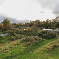
There was a notice of seeking possession on the gate when I got around to the far side. Looks like it's definitely going to be the replacement for the caravan park at Baltic Wharf. Shame for the caravan folk, really; this is sandwiched between major roads and not anything like as close to the pubs and other tourist-friendly places around the harbourside.
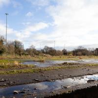
I was just about starting to feel better—the antibiotics seemed to have kicked in for my dental issues, and it had been some days since I'd left the house, and I was at last starting to get itchy feet. So, a wander. But where? Well, there were a few industrial bits near Winterstoke Road in the Ashton/Ashton Vale areas of Bristol that needed walking. I knew they were likely to be quite, well, unattractive, frankly. So why not do them while I wasn't feeling exactly 100% myself? Maybe it would fit my mood. Hopefully you're also in the mood for a bit of post-industrial wasteland, for that's what some of this feels like...
Then, at the last minute, I thought again about the Bristol International Exhibition—I've got a book about it on the way now—and that gave me another goal, which could just about be said to be in the same direction, and I decided to walk significantly further than my normal 1-mile limit and try recreating another historical photo...
Sadly I don't know much about the Ashton area; it's just on the edges of my mile and I rarely have cause to go there. It's brimming with history, I'm sure: the whole South Bristol area rapidly developed from farmland to coal mines to factories to its current interesting mixture of suburbs and industrial work over the last few hundred years. As a more working class area less attention was paid to it by historians, at least historically-speaking, than the Georgian heights of Clifton, and much of it has been knocked down and reinvented rather than listed and preserved. I see here and there some of this lack is being addressed, but I'm afraid I'll be very light on the history myself on this wander, as most of my usual sources aren't throwing up their normal reams of information as when I point them at Clifton, Hotwells or the old city.
I nearly didn't take this photo, having snapped this view so many times before, but I do find it almost completely irresistible.
I've often wondered about writing some kind of neural-computing based app that could look through all of my photos for snaps of this view and mash them all together into a time-lapse, or something, but that would be quite the project.
A better view of the ex-railway depot and part of the former Bristol International Exhibition site that I've mused about before. That's why we're on this wander, in fact: curiosity about an old photo of the site. But not a photo from round here: one taken from quite a ways beyond my normal mile radius. It's going to be a bit of a hike.
There will also be some terrifyingly industrial bits of south Bristol along the way, so be prepared for a bit of urban decay and industrial scenes.
A Random New Year's Day Wander
01 Jan 2022
I picked a fairly arbitrary reason for a wander today. Really, I just wanted to do a New Year's Day wander just to get out of the house and to set a precedent for the year to come.
My ostensible reason was to investigate what looked like a road on my map that quartered the lawn in front of the Ashton Court mansion. As it turned out, this is just a muddy footpath/desire line similar to a half-dozen other tracks nearby, and must be some kind of bug or misclassification with the mapping system I'm using, but that's not important. What's important is that I went for a little walk on the first day of the year. As a bonus, I did happen to wander down a couple of sections of new footpath, so technically I broke some new ground too, which is nice.
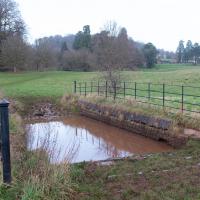
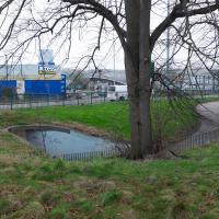
Strange little pond, yes? I think this may be a "cart dip" pond, used for rehydrating the wheels of old carts and carriages, which apparently kept things working better. Not sure on the details, though.