Tagged: cumberland-basin-flyover-system
Fresh Fields
17 Oct 2021
For the first time in a while, I had the time and energy to go further afield and knock off some new roads from my "to do" list. I headed through the first Hotwells Festival to Ashton and Bedminster to cross off a few of the suburban roads south of North Street.
First, though, I decided to try to reproduce an old photo of the now-demolished Rownham Hotel just around the corner from where I live...
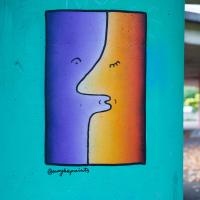
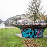
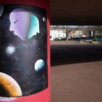
From @maybepaints, purveyor of "cheeky doodles round Bristol." It reminded me of this and by the looks of it that's by the same artist.
Well, presumably I'd be twice as happy, at least. Must tayk sum efurt 2 spell mor than haff ur wurds that badli.
Ticking Off a Few Streets in Bedminster
31 Oct 2021
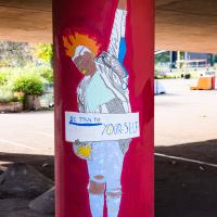
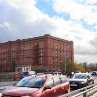
There were only a few streets left to wander in the more residential bit of Bedminster, so I thought I should target those today. The streets themselves weren't that notable, though Balfour Road has a contrasting mix of old and new housing. I tried to snap a few more interesting things along the way there and back, snapping all three of the familiar bond warehouses, nipping onto North Street to find some new street art, and finding a few pumpkins for good measure. It is hallowe'en, after all...
I went out simply wanting to knock off the very last little unwalked section of Clanage Road, over by Bower Ashton, which has been annoying me for a while as it's quite close by and I've walked the other bits of it several times. So, my plan was to nip over to Greville Smyth Park via a slightly unusual route to wander Clanage Road and tick it off.
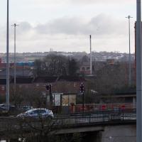
Along the way, though, I inevitably got a bit distracted. I took a few photos of Stork House, a grand Hotwell Road building that's recently been done up a bit (I imagine it's student lets, though I'm not sure) and which I found a reference to in a book about the Port Railway and Pier the other week, and also tried to match up a historical photo of Hotwells before the Cumberland Basin Flyover System laid it waste, which included some interesting markers I'll have to do a bit more digging into...
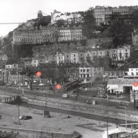
I found this image on Pinterest and as usual for that site it was annoyingly uncredited, but it seems to be from the book Hotwells, Spa to Pantomime, which I've just ordered direct from Bristol Books. Hopefully I'll be able to update the credit a bit when it arrives.
There's quite a lot in here that I didn't know about and will be researching a bit more, especially the Spa Assembly Rooms, which I think later turned into a school before being demolished for the flyover system, and also Anderson's workshop, a last vestige of the figurehead-carving industry.
I was trying to recreate the angle of the old, pre-Cumberland Road Flyover System photo that comes next. I couldn't get the angle, mostly because of the height, but this seems to be shot from about the right direction.
That historical photo seems to have been taken from a higher vantage point. The most likely place seems to be the B Bond, perhaps from that fire escape, or maybe the roof? Something tells me it's unlikely they'd let me up there, but you never know, maybe one day I'll ask an archivist; I think that area's part of the Bristol Archives stores...
Bower Ashton is an interesting little area just south of the river from me—in fact, the Rownham Ferry used to take people over from Hotwells to Bower Ashton, operating from at least the twelfth century to around the 1930s.
It's a strangely contradictory little area, with a cluster of old and new houses sandwiched in between the busy A-roads and significantly more industrial area of Ashton and the bucolic country estate of Ashton court roughly east to west, and also between Somerset and Bristol, north to south.
I've been around here before, mostly poking around Bower Ashton's arguably most well-known bit, the Arts faculty campus of the University of the West of England, but I'd missed at least Parklands Road and Blackmoors Lane, so I initially planned just to nip across briefly and wander down each in turn. On a whim, though, I texted my friends Sarah and Vik in case they were out and about, and ended up diverting to the Tobacco Factory Sunday market first, to grab a quick flat white with them, extending my journey a fair bit.
To start with, though, I nipped to a much more local destination, to see something that you can't actually see at all, the Gridiron...
(I also used this wander as a test of the cameras in my new phone. I finally upgraded after a few years, and the new one has extra, separate wide and telephoto lenses compared to the paltry single lens on my old phone. Gawd. I remember when speed-dial was the latest innovation in phones...)
The Gridiron and Bower Ashton Part Two
03 Dec 2021
On my last wander, to Bower Ashton, I was intending to knock Blackmoors Lane off my list "to-do" list, but got a bit diverted. I also took a little look into the history of the Gridiron, once a cheaper alternative to dry dock that was nestled just south of North Entrance Lock.
Today I had to go to send a parcel off somewhere, so I decided on going to the North Street Post Office via Blackmoors Lane. I didn't have much intention of anything else, but as luck would have it I walked out both at low tide and also as some lockkeepers seemed to be having a bit of a training session, and one of the more senior people was (a) happy to answer a few random questions on the Gridiron and (b) actually knew a lot about it, as Gridiron maintenance had been one of his jobs, more than twenty years ago...
I skipped the photography for the part of the wander where I went to the Post Office on North Street to send my old phone back to Apple for some trade-in, so here we are back at the end of Spike Island, heading back toward Hotwells.
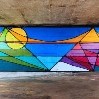
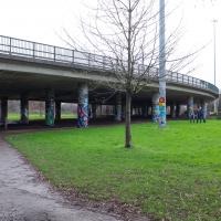
Last photo of the day: I had the luck to walk past AcerONE as he was putting the finishing touches to this new piece under the flyovers of the Cumberland Basin. It's called Avon Gorge. I love the stylised, stained glass feel to it.
He said he still had some shading to do, so I'll try getting another snap of the finished article on another day.
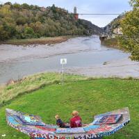
My friend Lisa texted me to see if I wanted to pop down and take a photo or two of the event she was taking part in: Santa SUP. SUP Bristol organise stand-up paddleboarding on the floating harbour, and their annual Santas-on-paddlboards event is quite the sight.
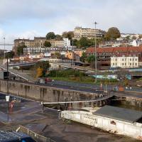
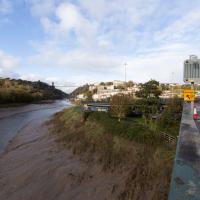
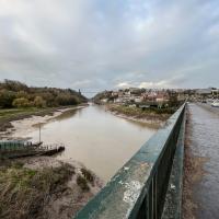
On the way there, I grabbed a historical photo I'd been wanting to recreate for a while of the shiny and new Cumberland Basin flyovers back in 1965, because I reckoned I could fit finding the same viewpoint into my outbound journey. Also, after having only used it on a wander for the very first time yesterday, I managed two crossings in the cross-harbour ferry today to get to the best locations for snapping the paddleboarders...
So, then, this wander is mostly a bunch of photos of paddleboarding Santas. Tis the season... Enjoy!
So, mostly this wander will be a panoply of photos of my friend Lisa and her paddleboarding friends making their way around the harbour dressed in Christmas outfits. But, on the way, I figured I'd try to reproduce another historical photo.
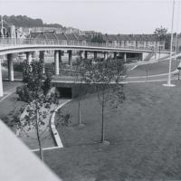
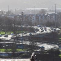
This one's from the Bristol Archives' collection of council Public Relations photos. Its title is "The northern side of the Cumberland Basin Bridges Scheme: Completed and landscaped, 1965".
I find that this actually looks quite nice, all clean and shiny and new. It probably looks very similar to the architect's drawing and scale models and what-have-you that they produce for these sorts of things.
Via Bristol Archives/Know Your Place.
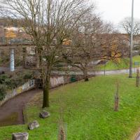
And here's the site today. The weathered concrete and tagging doesn't really improve things, but at least it looks like one of the original trees has thrived.
It's less so much the look of the road system, perhaps, and more that on a busy day it's just an urban hellscape of traffic and noise. On a Sunday like this you could actually believe that children could play here (there was originally a playground to go with the fountain and other features I'm mentioned in the past...)
However, most of the time, just like with the Portway, the sheer weight and (acoustic) volume of the traffic and its accompanying fumes and danger has clearly increased beyond anything the original planners ever envisaged.
I was just about starting to feel better—the antibiotics seemed to have kicked in for my dental issues, and it had been some days since I'd left the house, and I was at last starting to get itchy feet. So, a wander. But where? Well, there were a few industrial bits near Winterstoke Road in the Ashton/Ashton Vale areas of Bristol that needed walking. I knew they were likely to be quite, well, unattractive, frankly. So why not do them while I wasn't feeling exactly 100% myself? Maybe it would fit my mood. Hopefully you're also in the mood for a bit of post-industrial wasteland, for that's what some of this feels like...
Then, at the last minute, I thought again about the Bristol International Exhibition—I've got a book about it on the way now—and that gave me another goal, which could just about be said to be in the same direction, and I decided to walk significantly further than my normal 1-mile limit and try recreating another historical photo...
Sadly I don't know much about the Ashton area; it's just on the edges of my mile and I rarely have cause to go there. It's brimming with history, I'm sure: the whole South Bristol area rapidly developed from farmland to coal mines to factories to its current interesting mixture of suburbs and industrial work over the last few hundred years. As a more working class area less attention was paid to it by historians, at least historically-speaking, than the Georgian heights of Clifton, and much of it has been knocked down and reinvented rather than listed and preserved. I see here and there some of this lack is being addressed, but I'm afraid I'll be very light on the history myself on this wander, as most of my usual sources aren't throwing up their normal reams of information as when I point them at Clifton, Hotwells or the old city.
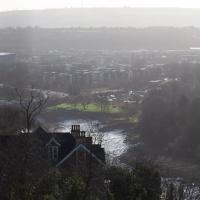
This may be somewhere around my actual destination today, though perhaps a little too much toward the east.
The buildings and green space on the hill in the background are the Knowle West Health Park. I'm pleased to have figured this out by using an OS map and a ruler and projecting a line from where I'm standing through the Tobacco Factory flag that you can just see poking up from Bedminster (you can see it on the corner of the building in this earlier pic](https://omm.gothick.org.uk/image/7175), then looking for densely-packed contour lines further out of town. Very old-school, but it worked!
I'm probably heading in more of a Bedminster Down direction. It's a similarly elevated green space further west, which is hidden behind the bond warehouse on the right in this pic.
A Random New Year's Day Wander
01 Jan 2022
I picked a fairly arbitrary reason for a wander today. Really, I just wanted to do a New Year's Day wander just to get out of the house and to set a precedent for the year to come.
My ostensible reason was to investigate what looked like a road on my map that quartered the lawn in front of the Ashton Court mansion. As it turned out, this is just a muddy footpath/desire line similar to a half-dozen other tracks nearby, and must be some kind of bug or misclassification with the mapping system I'm using, but that's not important. What's important is that I went for a little walk on the first day of the year. As a bonus, I did happen to wander down a couple of sections of new footpath, so technically I broke some new ground too, which is nice.
Strange to think that there was once, briefly, a castle here. More on that on some future wander, when I try to recreate another historical photo of the Bristol International Exhibition.
Near and Far
05 Jan 2022
I took advantage of a rare recent day where it wasn't tipping down with rain to get away from my desk on a lunchtime workday and head up to Clifton Village. I'd hoped to snap a reproduction of historical photo which I'd worked out had been taken from the Suspension Bridge, but the gods were not smiling on me. Still, taking only a nice long lens with me worked out very well as the lovely haze of the day made more distant views quite dramatic...
This is almost the photo I wanted to take, but the historical photo I want to reproduce was definitely taken from further to my right, on the bridge, and you should still be able to see the remains of Clifton Bridge Station (hidden from here by the trees on the right) and the last bit of slipway of the Rownham Ferry (hidden by the prominent house in the foreground.) This snap is also a bit marred by the temporary safety fencing I had to shoot through.
Ah well, another day, I suppose.
Bedminster Trip for New Walking Shoes
26 Feb 2022
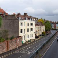
I needed to buy new walking shoes—my old ones were squeaking and it was driving me up the wall—so I ordered some for collection from Taunton Leisure on East Street in Bedminster, and decided to make picking them up an official wander.
I didn't cover any new ground within my mile, but I did take advantage of the trip to take in a few interesting things just outside my normal radius, mostly New Gaol-related. Along the way there are a couple of sanitation-related diversions, including a visit to a rare manhole cover. You can hardly wait, I can tell!

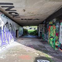
Hadn't spotted this one before. It's hidden away a little, tucked inside the entrance to the disused public toilets under the ramp for one of the Cumberland Basin flyovers.
You can pretty much take the word "disused" for read when it comes to public toilets in Bristol. Protesters recently wrote an open letter to the council demanding the re-opening of some of the many closed toilets.
The lack of access to public toilets in Bristol is not simply inconvenient – it raises issues of equality, and of dignity. Lack of toilets has led to the use of public spaces as substitute toilets – effectively open sewers in our city
As someone whose main form of exercise is walking through the city, I've definitely noticed the decreasing availability of public loos over the years. I can only imagine that my need for them will increase as the years go by...
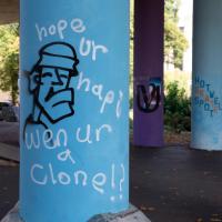
More by Maybepaints. Don't stop to think about the physics of it, just enjoy the artwork. And that's the end of the walk! Let's hope these new shoes don't turn out to be squeaky...