Tagged: cumberland-basin-flyover-system
In Which We Begin and End with Love
05 Mar 2022
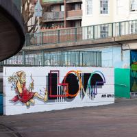
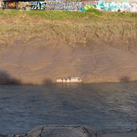
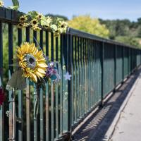
I had a lot to get done around the house, so as soon as I heard there might be a shiny new piece of street art near me, under the Cumberland Basin flyovers, I immediately decided that was all the excuse I needed to set off on a round-the-harbour lunchtime walk to get some fresh air and see if I could spot it. So, here's a circular wander that takes in graffiti, boats, wildlife and graffiti again...

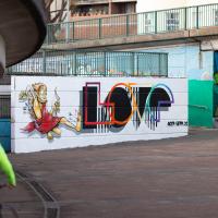
And we're back where we started. Incoming from the left is @beardedjourno, who is about to take the banner photo for this article, I believe :)
In the background on the right you can see another piece by AcerONE (also known as Luke) that I've previously featured.


Leigh Woods Purple Path
12 Mar 2022
There's a few tracks in Leigh Woods that lie within my mile and show up on my map but that I've not walked yet, so I decided to take one of my traditional big long walks through the woods on this nice crisp sunny morning.
For years—decades, even—I've been doing a similar route from my place, along the towpath to the far woods entrance, up the hill for a varied walk on one of the marked tracks and then across the Suspension Bridge to Clifton Village for a coffee-based reward. It's my default "long walk", really, and I almost always enjoy it. Today, at last, spring actually seemed to be springing, which made for some extra positivity...
There have been new plans put forward by the council for the Western Harbour Development The previous plans would have put a bridge in between here and the suspension bridge. I've not looked at the new ones yet.
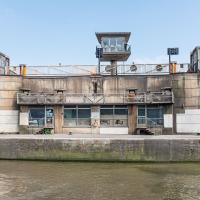
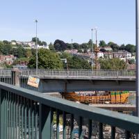
I'm sure both the entire flyover system and its monument bench looked splendid when they were first put up, in 1965.
Here you can hear a live performance of the song Virtute et Industrial by Adge Cutler and the Wurzels that includes a brief reference to the then-newly-completed flyover system:
Hast seen our brand new bridge, up there in Cumberland Basin?
The cars go by like thunder, and up and round and under
Where they goes, nobody knows, tain't no bleedin' wonder!

"Swing bridge machinery by Sir William Arrol & Co. Ltd": Sir William was knighted for his commitment to his work on both the Forth Bridge and the replacement Tay Bridge, erected following the loss of the previous bridge in the great Tay Bridge Disaster. He was also responsible for knocking up some other little bridges around the country, like london's Tower Bridge, to pick an example...
My friend Sarah made a podcast episode about Sylvia Crowe (credited bottom right on the plaque) and her development of the landscape in this area, with Wendy Tippett, a local landscape architect. It's a great listen if you're familiar with the area, and explains all sorts of things, including the PPILA after Sylvia Crowe's name on the plaque: Past President, Institute of Landscape Artists.
I mostly went out to hang out with my friends Sarah and Vik in Bedminster, but along the way I thought I'd take a closer look at something a little nearer home: the last crossing point of the Rownham Ferry.
At an earlier site, the ferry was mentioned in the Proceedings in the Court of the Star Chamber in the Reigns of Henry VII and Henry VIII after a dispute between a new competitor and the existing ferry, which was run by St Augustine's Abbey. Presumably the crossing was used to get to and from the abbey property at Abbots Pool, which I've actually swum in, from the Abbey, now Bristol Cathedral.

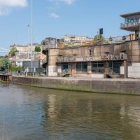
Much as I admire Sylvia Crowe's ambitious vision of her landscaping of the area the more I hear of it, I'm firmly in the camp who thinks the concrete now just looks grim and virtually anything improves it. I mean, it's not my cup of tea, but at least it brightens the dinginess up a bit.
A Swing of the Plimsoll Bridge
24 Apr 2022
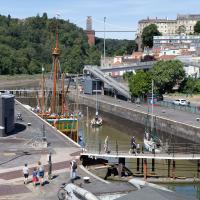
I was originally going to head over to the Ashton area to see if I'd missed any bits around the football stadium—and also to grab some lunch from the Tobacco Factory Market—but in the end I got a little distracted by having accidentally chosen exactly the right time to see the Plimsoll Bridge swing on one of the first busy days of Spring, where a lot of pleasure trips tend to head out down the Avon (and possibly the New Cut) from Hotwells.
In the end I mostly snapped that, and just a couple of photos from the Ashton area where I grabbed some lunch but didn't do any new exploring.
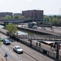
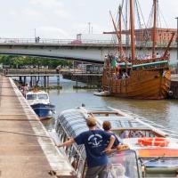
My first hint that there might be something interesting to look at was that the lock gates that I was planning on walking over were open rather than closed. Then I spotted the pleasure boat in the lock, just behind the descending steps from the footbridge there.
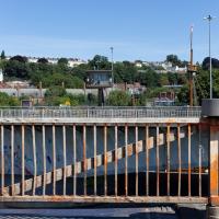
The Plimsoll Bridge is definitely not the oldest swinger in town. In fact, it may be the youngest swinger in town. I think the only other functioning swing bridges on the floating harbour (side-to-side rather than up-down like Redcliffe Bascule) are Junction Bridge (hidden in this picture, it's on the far side of the Cumberland Basin, carrying Merchants Road) and Prince Street Bridge, built in 1925 and 1879 respectively. The Plimsoll Bridge is mid-1960s.
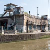
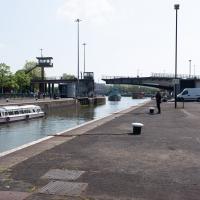
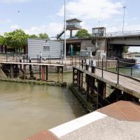
You don't often see this view of the brutalist bridge abutment, because the bridge itself is normally blocking and overshadowing the view here. Excuse me while I take far too many photos of it to be healthy.
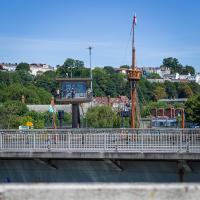
I've always particularly liked the spiral staircases and the control tower, which looks like it's escaped from a prison camp.
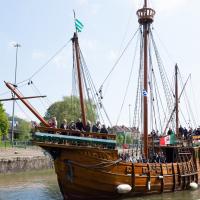
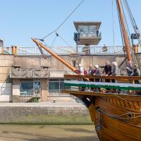
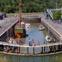
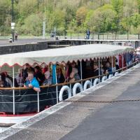
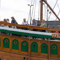
The brutalist bridge abutment is the old bit, of course, as it's mid-1960s. The boat that looks like John Cabot's 15th century caravel is the new bit. This replica was made in the 1990s, and replicated the original's 1497 trip to Newfoundland in 1997, arriving in June at Bonavista, to be greeted by Queen Elizabeth.
She's just had her annual inspection in the Albion dry dock, so I suppose this is one of her first gorge trips of the summer season.
You can see the man whose job it is to work the rather complicated-looking controls in the control tower has come out onto his balcony now the opening procedure is done.
A Quick Swing Past Ashton Court
05 Jun 2022
Another day not dissimilar to my last wander: I'm feeling a bit tired and rather than just moping around the house I thought I'd find some tiny bit of somewhere that I'd not yet walked and get outdoors. This time I headed for the Tobacco Factory Market in Bedminster, as I often do, but went the long way around via Ashton Court Mansion as I knew there were some footpaths and a small section of road I'd not ticked off up there. Finishing all the Ashton Court footpaths will be quite a long job, but you've got to start somewhere...
I did feel rather better by the time I got home, and, pretty much astoundingly given the weather forecast, managed to avoid the rain completely.
I've been pretty awful at reading so far this year, apparently averaging about one book per month. That's a far cry from 2019, say, where I got through 41 books in the year. Today's wander was prompted by my rubbish reading, as I needed to go hand back some books to the library, because I'd managed to renew them so many times that I hit the limit on renewals. Oops. Several of them were still unread.
So, off to the Central Library for me, tail between my legs. On the way there I did my best to recreate a historical photo of Dowry Square; while I was in the area I walked under the adjacent Norman arch and poked around behind the Cathedral, and I also had a little diversion to the city centre and came back along the south side of the river, hitting some trouble with the lock gates as I finally crossed the harbour back towards home.
While I was taking the last few photos I'd been hearing the two-tone alarm signal of a bridge swing, so I knew something would be going on at the lock when I got here. This time, though, I got more than I bargained for.
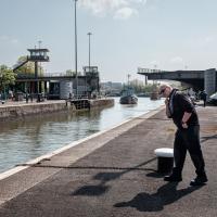
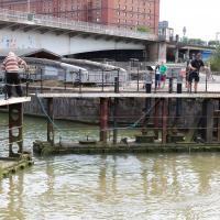
I was coming up to cross at these lock gates like normal when I saw that the lock keeper operating the hydraulics was having some difficulties. Sure enough, after a few attempts at closing the gates, it became apparent that they just weren't having any of it. They were getting this close to closing and then jamming.
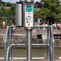
...which was good in some ways; I've always been curious about the control panel for the lock gates, and as the lockkeeper went to have a closer look at the gates themsevles I took this snap and, in the next photo, a close-up.
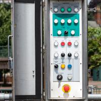
There's something very pleasing about industrial switchgear to me. This is comparatively modern, put in the last time the lock gates were replaced/refurbished, from what I remember, but still has that pleasingly 1950s look of good solid gear.
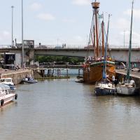
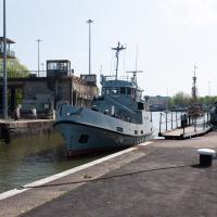
As you can see, there were quite a lot of boats waiting to leave Bristol for a jaunt down the river, most notably the Matthew, and Bristol Packet's Bagheera.
As a pedestrian I have a few alternative routes to cross. I decided to stroll down to the outer lock gate and get back to my side of the harbour there rather than going the long way around over the Plimsoll Bridge.
In the distance you can see a lockkeeper fishing in the water with a grappling hook on the end of some blue line to see if he can figure out what the gate is fouling on.
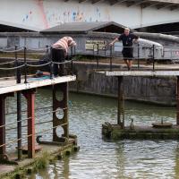
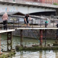
I was expecting them to pull a shopping trolley out at any moment. They weren't managing to snag anything, though.
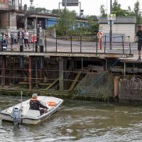
While I was tempted to hang around to see if they eventually pulled anything out of the way, the heat of the day was beating down pretty hard by this point and I didn't want to risk sunburn, so I headed home. As did all the boats in the lock, who returned back into Cumberland Basin and presumably eventually back to the city, refunding/rebooking their passengers.
I found out that my decision to leave had been a good one two days later, on Tuesday evening, when I happened to be on my walking commute home during another locking out, this time with the lock gates working. I asked the lock keeper about the problem, and apparently they'd tried hooking out whatever was fouling the gate for quite some time on Sunday, but eventually gave up and sent divers in on Monday, who pulled out a large section of chain-link fence that was fouling the south lock gate and got everything working again.
I'm in the habit of going over to the Tobacco Factory Market on a Sunday. I think I've walked all the routes around that way, but as a Plimsoll Bridge swing let me cross the road to the far side of Brunel Way on my return journey and I took a couple of photos of the brownfield development at the old Ashton Gate Depot site I thought I'd call it a Wander and pop some photos up.
Ah, but it seems like the bridge is closing, which might make it nice and safe to cross over and have more of a look from the other side. First, though, we'll nip down and have a look at what's causing the swing.
Now, what's actually meant to happen at this point is that all the traffic follows the giant flashing ALL TRAFFIC sign pointing to the exit ramp on the left. Then they go down the ramp, along a short stretch of road, cross the harbour at Merchants Road bridge (officially Junction Swing Bridge, in fact), join the Hotwell Road and continue on their merry way, without any cause for delay.
This never actually seems to happen, and a queue just forms here. Today this particularly annoyed the driver of a Waitrose van, presumably late for a delivery and stuck behind what he clearly thought were a line of idiots that he hooted angrily at for quite some time, to as much effect as you'd imagine.
One of the things I like about Bristol is the strange contrasts. Here we have two crow's nests. The first is the Cumberland Basin Flyover System's Plimsoll Bridge control room, used to give the swing bridge operator a good view of the whole area surrounding the bridge. The second is the reason for the swing, the crow's nest on the tall mast of the replica of John Cabot's Matthew, as it passes through into Entrance Lock.
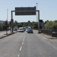
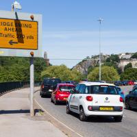
They really couldn't make it much clearer that drivers are meant to nip off down the off ramp up ahead and take Junction Swing Bridge instead. But if anyone ever does I've not seen it. I don't think I've ever been caught in the queue here as a driver, but then I don't do much driving.