Tagged: one
A Trip to the Library
08 Jun 2021
I had to return a book to the library—Ellic Howe's Magicians of the Golden Dawn, very interesting, thanks for asking—so I decided to pick the Central Library as my drop-off point and walk down a segment of Deanery Road that I've surprisingly overlooked so far. In any normal time I'd have been walking to work that way quite often, or heading through at the weekend on the way to do some shopping in the city centre, or for a coffee at St Nick's, but those excursions have been quite thin on the ground for the last year or so, for obvious reasons.
I've never been inside a single building on Deanery Road itself; the Library is technically on College Green and the rest is mostly student accommodation or Bristol College buildings, by the looks of things. It's a fairly mediocre street, used merely to get to other places. (St George's Road, which merges into it, at least has the distinction of several good shops verging from the practical and long-lived car radio fitters to the excellent little Dreadnought Books, sadly currently closed for refurbishment...)
After dropping off my book I came home via the harbourside, the better to enjoy the nice sunny blue skies of the day.
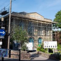
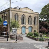
It's got a great font, and it's not even a baptist church.
Tags: Bristol Places UK onemilematt united kingdom Hotwells
Auto-Tags: Plant Sky Tree Building Neighbourhood Residential area Urban design Facade City Commercial building Mixed-use Electricity Road Apartment Vehicle
Text Recognition Tags: HUPE One way L.CKOUT HOS ABOUTI HUPE One way L.CKOUT HOS ABOUTI
A Cliftonwood Revisit with Lisa
10 Jul 2021
Lisa had a couple of hours to spare before going up in a hot air balloon (exciting!) so we went for a quick local walk, revisiting a bit of Cliftonwood we've seen before, exploring the secret garden I'd visited before that I thought she'd enjoy (I didn't take any new photos there) and then pushing on to another garden, Cherry Garden. Last time we passed this way, I'd noticed the gate, but we hadn't gone in as I'd assumed it was private. I'd since found it on CHIS's list of communal gardens in Clifton, so I wanted to have a look inside this time, and try to figure out whether it was private-communal or public, and possibly Council-owned, like several of the other gardens in Clifton.
It reminds me of The Prisoner, but Number One didn't have a front door, as I recall.
Tags: Bristol Places UK onemilematt united kingdom cliftonwood
Auto-Tags: Fixture Door Azure Wood House Home door Handle Facade Symmetry Door handle Font Arch Building Electric blue House numbering
Text Recognition Tags: number one number one
Green Squares and Secret Gardens
31 Jul 2021
At the end of July I went to have a look around some of the private gardens opened up by the annual Green Squares and Secret Gardens event. Sadly it was compressed into a single day this year, for various Covid-related reasons, it seems, so I didn't get to poke around too many places. I went to:
- A talk by the oldest resident of Victoria Square
- The St Vincent's Rocks Hotel garden
- The Paragon garden
- Cornwallis Crescent gardens, both east and west
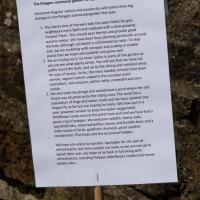
- The Polygon garden
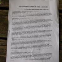
And snapped a few things in between, too. It was a lovely day—a bit too hot, if anything—and it was interesting to get into a few places I'd only ever seen from the outside, especially The Paragon and Cornwallis gardens, which are the least visible to passing strangers of all of them.
Tags: Bristol Places UK onemilematt united kingdom Clifton Village Clifton Cornwallis Crescent Garden Clifton Open Garden Squares Green Squares and Secret Gardens open day Cornwallis Crescent garden
Auto-Tags: Font Grass Wood Terrestrial plant Groundcover Grass family Plant Paper Commemorative plaque Rectangle Landscape Paper product Document Publication History
Text Recognition Tags: Cornwallis Crescent (West) G5SG - 31.07.2021 Welome-ease teel tree to wander round the garden and woodland Comwal Crescnta home to wel er 150 u. ng in 85 h holds cangng fromente huse to mesty sin oor tats-a larcry fron the originaly olanned 31 households Itnot at the demugraphi prute whch has changed, there na cane forsuggesting that the Crescent sureetly enjoyru a perod efunerecedemad ke, cae and attention fm the pret generation of reutents, Read o. The ongnal plan pronatly by AIta Pay as tor a mplete shullew cresmtol 4hes Work begat a1791, buc akeady the gret spetidative bukdng boo of the perkidwas beginnirg e colapie resaurs become scar, lons had to ome by as finwnciers and buiders were edered boninatnd the debide wan completed wiiti the decteration of war wth France in Bding work vtopped with i tal houne in vanous states of complenn The area inust have arpeaet etroordinary to ute hom this ommentaryof R07 1do noe ecalect mone melhoy oectace westem enros of ms citwamot avofuts are so none than a wok oea d dou t gh tre sent and folng nouses n andesd Theraher meal, with loass on unfinished hauses stit beng gramed an l The Cressent then proably enjoved a hart heydaythough Alan yder's briet testory shows that many f the houses had fong untannted periods dne thied of the houses in the wntern taif atood empty at the time of the I51 census for instance, and the stuation is itle better ty L89L with fiet of the twenty three houses untenarted ind a further thres inhabited only by cartaken The problem of coure was tht many of the buidings were owned hy sentee lindhordi-some of whom tad itle interest in mntaiing them let alone imeroving propress was pite them Nan goes on to show tw y the early twmtleth contury undatian hod beyan to rake to Ang with much of ctor the Cescnt was to beame by the middle of the cntury an anw d cheap maaned odgings reachng eadr in 136 tem he oty cdund proposed to demalah itin prer to bda block of huh-e Datir Comwalh Crescont survtaed-and gadualya nee gonration of residents mode the finsl uarter of the twentieth century perkod of rapid change and runewis for the Crescent. The widespread derekction so evident in the earker part of the oury was gradualy reversed an, house by house Hat ly fat the procs of restoration and renovation changed the Crescent boch inside and mut The Garden Hdden tehind the Crestent's buidings and thigh boundary wal, the gurden is aw a surpriee to wstars. it's the best part of an acre, faces dje south and is shettered from the north-making tideal for terder plants and sun warshippers alte It consists of three laur, two of witsch used to be terns courts and the woods whih slope steeply soun to the bundary wal on Polypon Lane. Our longmt-standing resident. Myrtle Way ememten ter beng played in the tne 1950, though less famaly, one imagines, than in 1906 when the Comwalts Tenni Clit wa fanned Cornwallis Crescent (West) G5SG - 31.07.2021 Welome-ease teel tree to wander round the garden and woodland Comwal Crescnta home to wel er 150 u. ng in 85 h holds cangng fromente huse to mesty sin oor tats-a larcry fron the originaly olanned 31 households Itnot at the demugraphi prute whch has changed, there na cane forsuggesting that the Crescent sureetly enjoyru a perod efunerecedemad ke, cae and attention fm the pret generation of reutents, Read o. The ongnal plan pronatly by AIta Pay as tor a mplete shullew cresmtol 4hes Work begat a1791, buc akeady the gret spetidative bukdng boo of the perkidwas beginnirg e colapie resaurs become scar, lons had to ome by as finwnciers and buiders were edered boninatnd the debide wan completed wiiti the decteration of war wth France in Bding work vtopped with i tal houne in vanous states of complenn The area inust have arpeaet etroordinary to ute hom this ommentaryof R07 1do noe ecalect mone melhoy oectace westem enros of ms citwamot avofuts are so none than a wok oea d dou t gh tre sent and folng nouses n andesd Theraher meal, with loass on unfinished hauses stit beng gramed an l The Cressent then proably enjoved a hart heydaythough Alan yder's briet testory shows that many f the houses had fong untannted periods dne thied of the houses in the wntern taif atood empty at the time of the I51 census for instance, and the stuation is itle better ty L89L with fiet of the twenty three houses untenarted ind a further thres inhabited only by cartaken The problem of coure was tht many of the buidings were owned hy sentee lindhordi-some of whom tad itle interest in mntaiing them let alone imeroving propress was pite them Nan goes on to show tw y the early twmtleth contury undatian hod beyan to rake to Ang with much of ctor the Cescnt was to beame by the middle of the cntury an anw d cheap maaned odgings reachng eadr in 136 tem he oty cdund proposed to demalah itin prer to bda block of huh-e Datir Comwalh Crescont survtaed-and gadualya nee gonration of residents mode the finsl uarter of the twentieth century perkod of rapid change and runewis for the Crescent. The widespread derekction so evident in the earker part of the oury was gradualy reversed an, house by house Hat ly fat the procs of restoration and renovation changed the Crescent boch inside and mut The Garden Hdden tehind the Crestent's buidings and thigh boundary wal, the gurden is aw a surpriee to wstars. it's the best part of an acre, faces dje south and is shettered from the north-making tideal for terder plants and sun warshippers alte It consists of three laur, two of witsch used to be terns courts and the woods whih slope steeply soun to the bundary wal on Polypon Lane. Our longmt-standing resident. Myrtle Way ememten ter beng played in the tne 1950, though less famaly, one imagines, than in 1906 when the Comwalts Tenni Clit wa fanned
Tags: Bristol Places UK onemilematt united kingdom Clifton Village Clifton Garden Clifton Open Garden Squares Green Squares and Secret Gardens open day The Polygon garden the polygon
Auto-Tags: Leaf Natural environment Plant Botany Vegetation Font Grass Terrestrial plant Wood Groundcover Landscape Signage Nature reserve Natural material Natural landscape
Text Recognition Tags: The Polygon communal garden- an update Welcome! Regular visitors and passers-by wili notice three big changes in the Polvgon communai garden this year. 1. The cherry tree at the west side has been felied (to give neighbours more light) and replaced with a slow growing Frosted Thorn. This should bear berries and provide good autumn colour. We have been busy planting perennials around the tree, although soil depth is stil limited by roots. To that end, we are mulching with compost and putting in smaller plants that we hope wil establish and grow well. 2. We are trying out a 'no mow policy in parts of the garden so we can see what plants arrive. You wil see that we have cut paths round the beds, and up to the sitting and compost areas for ease of access. So far, the most notable arrivals have been yamow, ragwort (which supports the cinnabar moth caterpiliar), red campion, yelow rattie, cranesbill and corn cockle. 3. We also took the plunge and established a pond where the oid firepit was situated up by the sitting area The pond has a population of frogs and water snails and we have spotted one dragon By so far but are hoping for more We have put in a solar powered aerator to keep the water ovygenated. Wildflower seeds around the pend took well and we have had a great crop of poppies. We weicome wildife: tawny owis, poistrelle bats, many butterflies, honey and bumble bees and a wide variety of birds goldfinch, dunnock, great spatted woodpecker. Plus foxes and the occasional badger. We hope you enjoy our garden. Apologies for the leck of refreshments, but many people are away so we are not up to speed. Next year, we hope to be back in full swing with refreshments, including Polvgon elderfiower cordial and home baked cakes. The Polygon communal garden- an update Welcome! Regular visitors and passers-by wili notice three big changes in the Polvgon communai garden this year. 1. The cherry tree at the west side has been felied (to give neighbours more light) and replaced with a slow growing Frosted Thorn. This should bear berries and provide good autumn colour. We have been busy planting perennials around the tree, although soil depth is stil limited by roots. To that end, we are mulching with compost and putting in smaller plants that we hope wil establish and grow well. 2. We are trying out a 'no mow policy in parts of the garden so we can see what plants arrive. You wil see that we have cut paths round the beds, and up to the sitting and compost areas for ease of access. So far, the most notable arrivals have been yamow, ragwort (which supports the cinnabar moth caterpiliar), red campion, yelow rattie, cranesbill and corn cockle. 3. We also took the plunge and established a pond where the oid firepit was situated up by the sitting area The pond has a population of frogs and water snails and we have spotted one dragon By so far but are hoping for more We have put in a solar powered aerator to keep the water ovygenated. Wildflower seeds around the pend took well and we have had a great crop of poppies. We weicome wildife: tawny owis, poistrelle bats, many butterflies, honey and bumble bees and a wide variety of birds goldfinch, dunnock, great spatted woodpecker. Plus foxes and the occasional badger. We hope you enjoy our garden. Apologies for the leck of refreshments, but many people are away so we are not up to speed. Next year, we hope to be back in full swing with refreshments, including Polvgon elderfiower cordial and home baked cakes.
A Morning of Research and a Cafe in a Castle
25 Sep 2021
I needed to pop to the library, as they'd kindly dug a book out of the reserve store at the B Bond warehouse for me and emailed me to let me know it was ready. So, I took a little trip to town, straight down the Hotwell Road, and spent a few hours reading before stretching my legs with a walk to a new cafe in the actual castle (or remnants thereof, anyway) of Castle Park, before heading back home down the other side of the harbour. As well as books and coffee, I bumped into a remote-controlled pirate ship, which isn't something you see every day, even in Bristol.
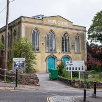
Not very different from yesterday's photo, but I do like the building, so here we are...
Tags: Bristol Places UK onemilematt united kingdom Hotwells
Auto-Tags: Plant Building Sky Window Car Tree House Street light Thoroughfare Vehicle Residential area Vehicle registration plate Facade Rural area City
Text Recognition Tags: НОРЕ СНАРEL One way hone of poer НОРЕ СНАРEL One way hone of poer
Recreating a Loxton Drawing on a Lunchtime Jaunt
05 Nov 2021
I did do a much longer wander earlier in the week, but that'll take me some time to process (and cast a plethora of photos into the "out-takes" pile!) In the meantime, here's my lunchtime jaunt, taken to give myself a break from doing the company bookkeeping to send to my accountant so the taxman doesn't sling me in chokey.
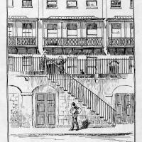
I've recently bought a slightly creased secondhand copy of Redcliffe Press's 1992 collection of Samuel Loxton drawings, Loxton's Bristol: The city's Edwardian years in black and white. It's a nice selection of Bristol Library's collection of the drawings. I'd noticed a drawing of 25 Royal York Crescent, a house I pass quite often, so I thought I'd wander up the crescent on the way to pick up some lunch and try to reproduce it.
On the way back I took a few photos of Clifton Hill Bank as the crowdfunder to make quite a lot of it into a wildflower meadow has just hit its target, so I figured some "before" shots might be a good investment for the future...
Loxton drawing from Bristol Library collection via Loxton's Bristol, Redcliffe Press, 1995 ISBN 1 872971 86 5.
Tags: Bristol Places UK onemilematt united kingdom Clifton Village Clifton Royal York Crescent Loxton Samuel Loxton 25 Royal York Crescent L908
Auto-Tags: Building Material property Art Font Parallel Landmark Urban design Rectangle Facade Illustration Drawing Line art House Pattern History
Text Recognition Tags: य वय 25, Royal York Crescent Royal York Crescent was completed in 1820 and has been claimed as the longest crescent in Europe. Number 25 was the home of Sir Abraham Roberts (1784-1873) who served in India and was described as one of England's greatest generals. 13 य वय 25, Royal York Crescent Royal York Crescent was completed in 1820 and has been claimed as the longest crescent in Europe. Number 25 was the home of Sir Abraham Roberts (1784-1873) who served in India and was described as one of England's greatest generals. 13
Easter Monday Gardens and Flowers
18 Apr 2022
I didn't really set out with a theme of flowers and gardens in mind for this walk. I just fancied heading up to Clifton Village to get lunch. As it turned out, though, Spring was springing, so a minor theme emerged as I started off with the graveyard flowers of Hope Chapel and wandered up to see the beginnings of the new wildflower garden at Clifton Hill Meadow.
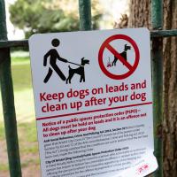
There's been some commotion on Nextdoor about the recent appearance of this sign. Lots of people who have been letting their dogs off their leads in the churchyard for decades have been rather up in arms. I'm not sure there's actually much danger of the rozzers issuing ASBOs or fines to the locals for that kind of infraction, though.
Tags: Bristol Places UK onemilematt united kingdom Clifton Village Clifton St Andrew's churchyard birdcage walk Lime Walk
Auto-Tags: Green White Nature Natural environment Grass Font Biome Line Plant Public space Woody plant Tree Signage Motor vehicle Street sign
Text Recognition Tags: ㅅ Keep dogs on leads and clean up after your dog Notice of a public spaces protection order (PSPO)- All dogs must be held on leads and it is an offence not to clean up after your dog Anti-Social Behaviour Crime And Policing Act 2014, Section 59Notice is hereby given that Bristol City Council (the Council) in exercise of its powers under Section 59, 63 and 72 of the Anti-social Behaviour, Crime and Policing Act 2014 The Act, being satisfied that the conditions set out in section 59 of the Act have been met, made the following Onder City Of Bristol (Dog Control) Public Spaces Protection Order 2020. A Fored Penalty Notice may be issued to a person who a comitable or authorised person has reason to believe has committed an offence in relation to this One offering the person to whom it is issued the opportunity of dischinging any lability to conviction for the offence by payment of a fiend penalty Scene dog fouling provisions and the Exclusion Zones de not app assistance dogs Further information about the PSPO and the front of the Onder can be found at Public Space Protection (PSPO)-bristol.gov.uk ㅅ Keep dogs on leads and clean up after your dog Notice of a public spaces protection order ( PSPO ) All dogs must be held on leads and it is an offence not to clean up after your dog Anti - Social Behaviour Crime And Policing Act 2014 , Section 59Notice is hereby given that Bristol City Council ( the Council ) in exercise of its powers under Section 59 , 63 and 72 of the Anti - social Behaviour , Crime and Policing Act 2014 The Act , being satisfied that the conditions set out in section 59 of the Act have been met , made the following Onder City Of Bristol ( Dog Control ) Public Spaces Protection Order 2020 . A Fored Penalty Notice may be issued to a person who a comitable or authorised person has reason to believe has committed an offence in relation to this One offering the person to whom it is issued the opportunity of dischinging any lability to conviction for the offence by payment of a fiend penalty Scene dog fouling provisions and the Exclusion Zones de not app assistance dogs Further information about the PSPO and the front of the Onder can be found at Public Space Protection ( PSPO ) -bristol.gov.uk
I've been pretty awful at reading so far this year, apparently averaging about one book per month. That's a far cry from 2019, say, where I got through 41 books in the year. Today's wander was prompted by my rubbish reading, as I needed to go hand back some books to the library, because I'd managed to renew them so many times that I hit the limit on renewals. Oops. Several of them were still unread.
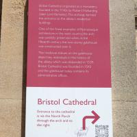
So, off to the Central Library for me, tail between my legs. On the way there I did my best to recreate a historical photo of Dowry Square; while I was in the area I walked under the adjacent Norman arch and poked around behind the Cathedral, and I also had a little diversion to the city centre and came back along the south side of the river, hitting some trouble with the lock gates as I finally crossed the harbour back towards home.
Tags: Bristol Places UK onemilematt united kingdom City Centre St Augustine's Cathedral Choir School Cathedral School college square
Auto-Tags: Font Rectangle Pink Material property Magenta Publication Pattern Wood Carmine Paper Paper product Commemorative plaque Signage Circle History
Text Recognition Tags: Abbot's Gatehouse Bristol Cathedral originated as a monastery founded in the 1140s by Robert Fitzharding (later Lord Berkeley) This archway formed the entrance to the abbey's residential buildings One of the finest examples of Romanesque architecture in the west country, the arch was carefully preserved when, in the fifteenth century, the two-storey gatehouse was constructed over it. The medieval statues on the gatehouse depict key individuals in the history of the abbey, which was disbanded in 1539. Bristol Cathedral was founded in 1542 and the gatehouse today contains its administrative offices. Bristol Cathedral Entrance to the cathedral is via the North Porch through the arch and to the right SHAND 200 ACER B HODERN Abbot's Gatehouse Bristol Cathedral originated as a monastery founded in the 1140s by Robert Fitzharding ( later Lord Berkeley ) This archway formed the entrance to the abbey's residential buildings One of the finest examples of Romanesque architecture in the west country , the arch was carefully preserved when , in the fifteenth century , the two - storey gatehouse was constructed over it . The medieval statues on the gatehouse depict key individuals in the history of the abbey , which was disbanded in 1539 . Bristol Cathedral was founded in 1542 and the gatehouse today contains its administrative offices . Bristol Cathedral Entrance to the cathedral is via the North Porch through the arch and to the right SHAND 200 ACER B HODERN
Nipping Up the Zig Zag to the Shops
19 Aug 2023
It's been a long while since I did one of these walks.
I'm thinking of finishing up the project by walking one or two last bits of road, thus being able to declare with all honesty that I've done my best to walk every public road within my mile (and quite a few alleyways besides.) As a prelude, and just because I felt like it, I decided to drag out the camera and GPS on this little wander to the local shops.
I may not personally be a fan of evangelical Christianity, but at least they keep the place looking nice. It's still very tidy since the recent renovation, installaltion of solar panels on the roof and repainting of the HOPE CHAPEL sign.
More notices, including a couple of newcomers to the local businesses: Hopewell, an estate agency, has opened up just down Hopechapel Hill in the place of The Landmark Practice (an environmental consultancy firm that seem to have moved out to Long Ashton) and HappyBack, who I'd noticed appearing down on the Hotwell Road a month or two ago.
Tags: Bristol Places UK onemilematt united kingdom Clifton Village Hotwells Clifton
Auto-Tags: Poster Font Gas Signage Advertising Facade Display board Billboard Town City Machine Transport
Text Recognition Tags: SAVE JACOBS WELLS your We W ty WS Na à Order w a gratyf Lauan ya wld worldcat HERE THE PETI Cale wwwwww CHBUEC C www d Dabe 17 TANTO F www. 0-100 Your journey is our journey and we are here to help you every step of the way Wend fpwith vir Ourica apteert papper mating nything t neces or Sc ng vs Shack and petere p FM 2 yan unteers Needed 0/0 70-23 DAN HappyBack Find Ho D Highly experienced Physiotherapy. Osteopathy and H® Massage specialists, helping you to get your happy back! W Lifeskills Lifeskills Learning for Living Py Acad Marg back. people to join our amazing toomer volunteers Oxime ww We are your new neighbours! pelare a prsity independent state aguny tinging together every best o ort, medium Alongtam ss and mes for sale across the city ravis A NEW Ma # HOPEWELL Come and say hello at our new offic orated at Hope Chcel House Hone Chapel Hill BSB IND 0117 911 8663 CERED ww are acest (10-only) og for new SANT FREE PEER SUPPORT GROUP TUESDAYS ONLINE 6.30-8.30pm 24ury Facilitated by LGBTQIA people Safe, nonjudgemental, confidential space to discuss mental wellbeing with other LGSTOLA+people Trinity Lunch Club Thursdays 10am-3:30pm Morning Coffee Armchair Excises 3 Course Home Cooked Lunch CET ARTIN Quiz Activities Tea & Biscuits For more information Call 07458 300 210 or email tes@holytrinityhotwells.org Holy Trinity Church serving the communities of Hotwells, Cliftonwood, Saike Island, Harboursie holytrinityhotwells.org Alexander May Having a baby? 42- AU You and your birth partner weinstela Calm Births Hypnobirthing FREE TASTER SESSION, online with Dolanan Monday th September OXO 7.30pm P By placeb www.dealbws.com We are devastated by the fire at the Underfall Yard. fre The fee has destroyed the heart of the Yard where most of the boat building activity takes place and tenant's businesses and boats have. been ruined. Thankfully no one was killed and no on was injured, but a lot of people in the Underfall Yard community have been impacted our staff, our tenants, our volunteers and our neighbours on Avon Crescent and Nova Scotia Place. Our hearts are with them and we are supporting our tenants as best we can. P DARO l HIER UNDERFALL YARD TRUST The Underfall Yard Trust was formed i the 1990's to bring the Underfall Yard out of dereliction, to look after the historio buildings, to shine a light on Bristoll's engineering harbour heritage and to promote traditional marine skills. In light of the devastation at the Yard, those aims remain as relevant now as they were then, SE We absolutely are committed to rebuilding the Underfall Yard and continuing the charity's work, If you would like to support the Trust, please see our JustGiving page, scan the QR code or alternatively, there is a donation box located on the Café till. https://www.justgiving.com/theunderfallyardtrust SAVE JACOBS WELLS your We W ty WS Na à Order w a gratyf Lauan ya wld worldcat HERE THE PETI Cale wwwwww CHBUEC C www d Dabe 17 TANTO F www . 0-100 Your journey is our journey and we are here to help you every step of the way Wend fpwith vir Ourica apteert papper mating nything t neces or Sc ng vs Shack and petere p FM 2 yan unteers Needed 0/0 70-23 DAN HappyBack Find Ho D Highly experienced Physiotherapy . Osteopathy and H® Massage specialists , helping you to get your happy back ! W Lifeskills Lifeskills Learning for Living Py Acad Marg back . people to join our amazing toomer volunteers Oxime ww We are your new neighbours ! pelare a prsity independent state aguny tinging together every best o ort , medium Alongtam ss and mes for sale across the city ravis A NEW Ma # HOPEWELL Come and say hello at our new offic orated at Hope Chcel House Hone Chapel Hill BSB IND 0117 911 8663 CERED ww are acest ( 10 - only ) og for new SANT FREE PEER SUPPORT GROUP TUESDAYS ONLINE 6.30-8.30pm 24ury Facilitated by LGBTQIA people Safe , nonjudgemental , confidential space to discuss mental wellbeing with other LGSTOLA + people Trinity Lunch Club Thursdays 10 am-3:30pm Morning Coffee Armchair Excises 3 Course Home Cooked Lunch CET ARTIN Quiz Activities Tea & Biscuits For more information Call 07458 300 210 or email tes@holytrinityhotwells.org Holy Trinity Church serving the communities of Hotwells , Cliftonwood , Saike Island , Harboursie holytrinityhotwells.org Alexander May Having a baby ? 42 AU You and your birth partner weinstela Calm Births Hypnobirthing FREE TASTER SESSION , online with Dolanan Monday th September OXO 7.30pm P By placeb www.dealbws.com We are devastated by the fire at the Underfall Yard . fre The fee has destroyed the heart of the Yard where most of the boat building activity takes place and tenant's businesses and boats have . been ruined . Thankfully no one was killed and no on was injured , but a lot of people in the Underfall Yard community have been impacted our staff , our tenants , our volunteers and our neighbours on Avon Crescent and Nova Scotia Place . Our hearts are with them and we are supporting our tenants as best we can . P DARO l HIER UNDERFALL YARD TRUST The Underfall Yard Trust was formed i the 1990's to bring the Underfall Yard out of dereliction , to look after the historio buildings , to shine a light on Bristoll's engineering harbour heritage and to promote traditional marine skills . In light of the devastation at the Yard , those aims remain as relevant now as they were then , SE We absolutely are committed to rebuilding the Underfall Yard and continuing the charity's work , If you would like to support the Trust , please see our JustGiving page , scan the QR code or alternatively , there is a donation box located on the Café till . https://www.justgiving.com/theunderfallyardtrust
