Tagged: slope
Leigh Woods Purple Path
12 Mar 2022
There's a few tracks in Leigh Woods that lie within my mile and show up on my map but that I've not walked yet, so I decided to take one of my traditional big long walks through the woods on this nice crisp sunny morning.
For years—decades, even—I've been doing a similar route from my place, along the towpath to the far woods entrance, up the hill for a varied walk on one of the marked tracks and then across the Suspension Bridge to Clifton Village for a coffee-based reward. It's my default "long walk", really, and I almost always enjoy it. Today, at last, spring actually seemed to be springing, which made for some extra positivity...
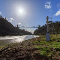
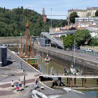
I mostly went out to hang out with my friends Sarah and Vik in Bedminster, but along the way I thought I'd take a closer look at something a little nearer home: the last crossing point of the Rownham Ferry.
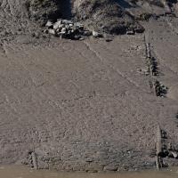
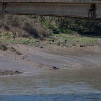
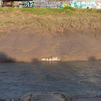
There, hopefully you can see it now—the slipway of the last incarnation of the Rownham Ferry, in use from as early as the 12th century to 1932, when this particular slipway was last used.
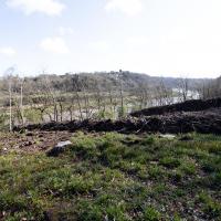
There's not much to see at the moment, as the tide's a bit too high. I'm going to head over to the Tobacco Factory Market, meet some friends, do a crossword or two, and head back at lower tide.
Again, the slipway is easy to miss. I like these little barely-visible curiosities that hide such heritage. The site of the crossing moved around—it's fairly obvious it wasn't right here in the 12th century, for example, because the river was only diverted into the New Cut, which the ferry crosses here, in the early 1800s. Earlier it was further downstream.
At an earlier site, the ferry was mentioned in the Proceedings in the Court of the Star Chamber in the Reigns of Henry VII and Henry VIII after a dispute between a new competitor and the existing ferry, which was run by St Augustine's Abbey. Presumably the crossing was used to get to and from the abbey property at Abbots Pool, which I've actually swum in, from the Abbey, now Bristol Cathedral.
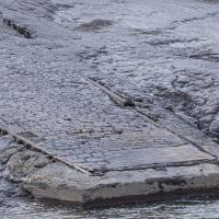
Looks like the stones at the bottom corner were replaced with some simple poured concrete with grip lines drawn across it at some point.
I noticed I had a few things on my "potential wanders" list that could all be done relatively close to home, and in a fairly straight line, so I set off at lunchtime to recreate a photo of a now-defunct pub, wander behind a Spar (which turned out to be more interesting than I'd expected, but I admit it's a low bar) and spend some time browsing in Dreadnought Books before coming home via a coffee from Spoke & Stringer, a little diversion up Gasworks Lane and a tiny bit of the Rownham Mead estate I'd somehow previously skipped.
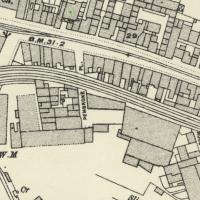
On Know Your Place you can check out old maps of Bristol. Sadly there doesn't seem to be an easy way of linking to a particular map/location. Still, here's a little screenshot of the 1898-1939 layer. These tracks are still there on the later 1949 map, so at least this section survived the war, I think.
Having checked Wikipedia I think this section, which ran from Canons Marsh to Ashton Avenue Bridge and then on to the south was created in 1906, and closed in 1965.
This map fragment will be © Ordnance Survey.
A Quick Swing Past Ashton Court
05 Jun 2022
Another day not dissimilar to my last wander: I'm feeling a bit tired and rather than just moping around the house I thought I'd find some tiny bit of somewhere that I'd not yet walked and get outdoors. This time I headed for the Tobacco Factory Market in Bedminster, as I often do, but went the long way around via Ashton Court Mansion as I knew there were some footpaths and a small section of road I'd not ticked off up there. Finishing all the Ashton Court footpaths will be quite a long job, but you've got to start somewhere...
I did feel rather better by the time I got home, and, pretty much astoundingly given the weather forecast, managed to avoid the rain completely.
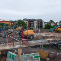
Yup, it's definitely all kicking off. They'll probably manage to build an entire development here before the Council finish fixing the bit of Cumberland Road that collapsed just around the corner.
I'm in the habit of going over to the Tobacco Factory Market on a Sunday. I think I've walked all the routes around that way, but as a Plimsoll Bridge swing let me cross the road to the far side of Brunel Way on my return journey and I took a couple of photos of the brownfield development at the old Ashton Gate Depot site I thought I'd call it a Wander and pop some photos up.
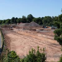
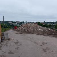
I walked back to the point I'd spotted all this activity from the far side of the road. This is the old tile merchant/concrete works/Ashton Gate Railway Depot/Bristol International Exhibition site. I imagine it was plenty of other things along the way, too. Here's an earlier snap with a bad photo from the far side of the site, but some detail on what the site was/will be along with a link to planning documents.
I'm currently toying with the idea of a little mini-website that takes a digitised and vectorised version of the Bristol International Exhibition plan (from 1914) and superimposes it on the same area today. It'd be interesting to see exactly where things were. My best guess from eyeballing it at the moment is that in 1914, this view would be looking towards the International Pavilion, Concert Hall and Art Gallery areas of the Exhibition, and we'd be standing on the train tracks that used to head for Ashton Avenue Bridge, which back then would have been a double-decker road and rail swing bridge, with the trains on the ground level deck, the road on the top deck, and a high-level swing control room above it all. Quite some feat of engineering.
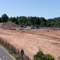
I wonder how many different things this patch of land has been over the years? I imagine it was one of the choice "brownfield" sites for some new flats down here. It's certainly doing its best to look very "brownfield" today!
Nipping Up the Zig Zag to the Shops
19 Aug 2023
It's been a long while since I did one of these walks.
I'm thinking of finishing up the project by walking one or two last bits of road, thus being able to declare with all honesty that I've done my best to walk every public road within my mile (and quite a few alleyways besides.) As a prelude, and just because I felt like it, I decided to drag out the camera and GPS on this little wander to the local shops.
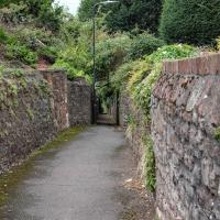
My exercise for the day is to be a short sharp shock: first we descend down Hinton Lane to the Hotwell Road, then I'm going to ascend the Zig Zag, and possibly die in the process. My fitness has suffered recently because although I've been keeping my step count up it's mostly been on the fairly flat commute to work and back, so hills are coming as a bit of a shock to the system at the moment.
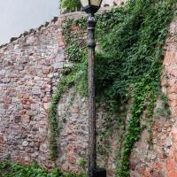
One of many exemplars of the sorry state of the historic cast iron lamp posts of Clifton Village. I get the feeling that the Council wish they'd all just rust away so that they can be replaced by cheap ugly lighting rather than needing any kind of maintenance.
On that somewhat sour note, I headed home before the few spots of rain I felt became anything more severe.