Tagged: concrete
Of Bridges and Buoys
04 Mar 2021
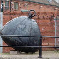
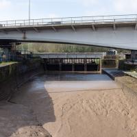
A trip to Imagine That coffee, so no fresh roads knocked off my list, but I stopped off to snap a couple of the engineering-related bits of the docks: the Campbell Buoy (used by P&A Campbell for mooring their paddle steamers) and Brunel's "other" bridge, the foot/horse swing bridge that now sits sadly disused in the shadow of the Plimsoll Bridge at Howard's Lock.
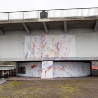
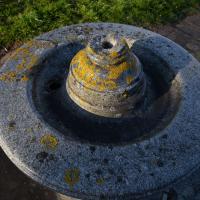
This is the pivot point for the Plimsoll Bridge. I don't think I've ever been down right here when it's swung.
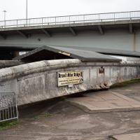
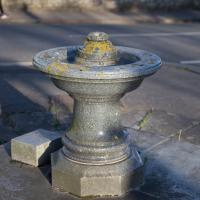
Brunel's Other Bridge ("Bob") was originally made to carry traffic over the South Entrance lock.
As part of the redesign/replacement of the North Entrance lock by Docks Engineer Thomas Howard, it was shortened and moved here, to the lock now known as Howard's Lock.
It was decommissioned in 1968 after the giant Plimsoll swing bridge that dwarfs it in the picture was put in as part of the Cumberland Road Flyover system.
A team of dedicated volunteers have been restoring it and documenting the process, and the bridge itself.
One Albermarle Row, Granby Green and... People
12 Mar 2021
I was browsing some historical photos the other day, and came across "Rear of Unspecified House" in the Bristol Archives' John Trelawny Ross collection, and immediately recognised it as being the back of 1 Albermarle Row, just around the corner from me. I've not had much time to research the history of this odd little addition to Albermarle Row, or what happened to 1-4 Cumberland Place, number 4 of which used to be attached to the side of 1 Albermarle Row, but it was interesting to look at old maps for a few minutes and work out what used to be where.
That all connects with the little local bit of land at Granby Green, too, as it used to be numbers 1-3 Cumberland Place. There was something of a planning battle over Granby Green, and I've included an old edition of Hotwells & Cliftonwood News that I found online, a copy of which would have been popped through my letterbox at the time.
I was also inspired by some old pictures of Hotwell Road to try to put a few more people in my pictures, though I set my pre-focus a couple of extra metres out from normal to make sure I didn't get too close to anyone!
This modern block has appeared since I've lived in the area, so it must be newer than 1999, I think.
South Entrance lock, re-done by Brunel in 1844-49 because it was too narrow, but has been walled up since the 1950s, hence it not mattering too much about the silt these days.
You can just about see the wire stretched across from left to right that the kayak polo teams that play here string their goals from.
John Carr's Terrace
16 Mar 2021
I wanted a nice simple lunch-hour walk that took me past a cafe today, and I managed to find the perfect road to knock off my list of targets to do it. Situated just off Jacobs Wells Road, right next to Queen Elizabeth's Hospital, John Carr's Terrace, and Rosebery terrace above it, which I'd completely forgotten existed, are a little cul-de-sac that many Bristolians will have wandered past a thousand times without ever seeing.
There's a reason it's next to QEH:
Known traditionally as "The City School", Queen Elizabeth's Hospital was founded by the will of affluent merchant John Carr in 1586, gaining its first royal charter in 1590.
John Carr's terrace itself isn't much to write home about, architecturally, but I like the secluded feel of it, and I really liked Rosebery Terrace with its little houses, commanding position and friendly, slightly tumbledown feel.
On the way home I popped into Foliage Cafe for a coffee and a very pleasant nutella and banana pastry, then walked home past the refurbishment of the old Thali Cafe into a new and interesting clinic...
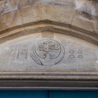
Among other things in its colourful history, the former Brandon Methodist Church was, for a while, the Japan Arts Centre, which probably explains this detail from its tympanum. I remember walking past when it had big adverts outside for martial arts. They used to teach Judo, Aikido and Karate, I think.
Harbourside Milestone
17 Mar 2021
The other day I realised (hello, Maggie!) that my next walk would be my hundredth, and that I'd done 393.4km so far. I figured it would be nice to get to 100 walks and 400km on the same walk, so I went for a nice long harbourside wander after work, rather than dashing out at lunchtime. As it turned out, we're just coming up to the time of year where I can leave the house at 5:30 in the evening and there's still just enough light to take photos by the time I've made it around the harbourside. Though only just, and mostly because I've got a full-frame camera that's not bad in low light...
Still, the evening light made a lovely change, and some of the photos turned out to be pretty good photos per se, rather than just record shots of my walk. I'm looking forward to more evening walks like this as summer approaches.
On the way around this evening I wandered through one of the oldest bits of the city to extend my walk and snapped some interesting bits of architecture, including an NCP car park(!) and a nighttime shot of one of my favourite subjects, the clock tower at the Albion dockyard.
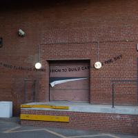
This is actually a Banksy work, not as well-known as many. Oddly, it seems like this loading bay may have been added after the graffiti was put there, and the graffit carefully transferred. I'll have to find out whether that's what actually happened...
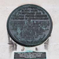
From Wikipedia:
William Friese-Greene (born William Edward Green, 7 September 1855 – 5 May 1921) was a prolific English inventor and professional photographer. He is principally known as a pioneer in the field of motion pictures, having devised a series of cameras in 1888–1891, with which he shot moving pictures in London. He went on to patent an early two-colour filming process in 1905. His inventions in the field of printing – including photo-typesetting and a method of printing without ink – brought him wealth, as did his chain of photographic studios. However, he spent everything he earned on inventing, went bankrupt three times and was jailed once, before dying in poverty.
This year there's apparently a year-long celebration of his life and work.
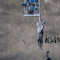
It's seen better day. Virtually every Banksy appears to be either vandalised or stolen as soon as it turns up in Bristol these days. Wikipedia even has an article devoted to a list of his works that have been destroyed.
I wasn't going to take a very long walk on this nice spring evening; it just happened. I was going to knock off a path or two on Brandon Hill, home over centuries to hermits and windmills, cannons and Chartists, and then just wander home, stopping only to fill up my milk bottle at the vending machine in the Pump House car park.
However, when I heard a distant gas burner I stayed on the hill long enough to see if I could get a decent photo of both the hot air balloon drifting over with Cabot Tower in the same frame (spoiler: I couldn't. And only having the fixed-focal-length Fuji with me didn't help) and then, on the way home, bumped into my "support bubble", Sarah and Vik, and extended my walk even further do creep carefully down the slipway next to the old paddle steamer landing stage and get some photos from its furthest extreme during a very low tide...
According to the Whitley Pump (twinned with St John's Conduit!) website:
Carmelite monks constructed St John’s Conduit, to carry water from the nearby spring to a friary that occupied the site now occupied by Bristol Beacon (Colston Hall as-was.)
It still carries water to a fountain outside St John the Baptist Church on Quay Street, which I'll have to go and have a look at—it's the church at the end of Broad Street, where National Westminster Insurance Services, my first employer in Bristol, used to be.
Presumably some of it also used to pop out here, but that's just a guess. The map of medieval cellars and conduits seems only to show a pipe passing near here from the Jacobs Well spring, not from the St John's source, which looks to be in Berkeley Square.
There's a bit more info here.
I got interested in Bristol's medieval water supplies after poking around near Jacobs Wells Road and Brandon Hill. It was during that research I found out about a pipe that's still there today, and, as far as I know, still actually functioning, that was originally commissioned by Carmelite monks in the 13th century. They wanted a supply of spring water from Brandon Hill to their priory on the site of what's now the Bristol Beacon—Colston Hall, as-was. It was created around 1267, and later, in 1376, extended generously with an extra "feather" pipe to St John's On The Wall, giving the pipework its modern name of "St John's Conduit".
St John's on the Wall is still there, guarding the remaining city gate at the end of Broad Street, and the outlet tap area was recently refurbished. It doesn't run continuously now, like it did when I first moved to Bristol and worked at the end of Broad Street, in the Everard Building, but I believe the pipe still functions. One day I'd like to see that tap running...
There are a few links on the web about the pipe, but by far the best thing to do is to watch this short and fascinating 1970s TV documentary called The Hidden Source, which has some footage of the actual pipe and also lots of fantastic general footage of Bristol in the seventies.
On my walk today I was actually just going to the building society in town, but I decided to trace some of the route of the Carmelite pipe, including visiting streets it runs under, like Park Street, Christmas Street, and, of course, Pipe Lane. I also went a bit out of my way to check out St James' Priory, the oldest building in Bristol, seeing as it was just around the corner from the building society.
There are far too many pictures from this walk, and my feet are now quite sore, because it was a long one. But I enjoyed it.
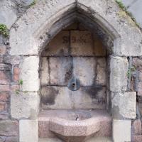
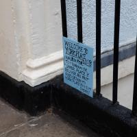
Believe it or not, this little pavement marker says "St John's Conduit" and marks the still-functional Carmelite water pipe that was built in 1267 to bring water from a spring near the top of Park Street to the Priory where Bristol Beacon now stands, with a "feather" branch added later (1376) to bring water to St John's church. Source: Bristol's Fascinating Fountains, Temple Local History Group
Just to remind myself that although it's on the map, I couldn't really have walked down it.
I'm here because it's one of the streets that the "feather" water pipe from the original Carmelite pipe to St John's Church travels down. Not expecting to see any evidence of it; I just fancied tracing its path a bit.
I bumped into my friend Lisa in town during yesterday's wander, and we decided to have a wander today, too. We managed quite a long ramble, starting up through Clifton and nipping down Park Row to investigate the two tower blocks I'd noticed popping up behind Park Street yesterday, then took in a few roads I'd not managed to get to before, including cutting through the grounds of Bristol Grammar School.
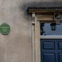
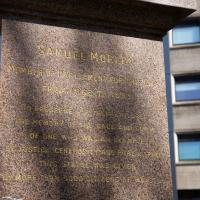
I have snapped this plaque before, but apparently I didn't look up the name. He designed the Wills Memorial Tower, one of Bristol's most significant landmarks, and one I snapped just yesterday.
I've mentioned before how this apparently continuous road contains York Place, Tottenham Place, Dover Place, Meridian Place, Bruton Place and Park Place—unsurprisingly it's confusing the delivery drivers. Some of the terraces re-start the numbering, so it can't be easy to figure out where you're meant to drop the pizzas off.
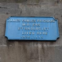
As well as ethnology, James Cowles Prichard was a psychiatric pioneer, serving as the—believe it or not—Commissioner for Lunacy, and was also the first person to define "senile dimentia" in the English language.
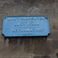
The Red Lodge is the sister historic house museum to The Georgian House, this one being Tudor/Elizabethan. These plaques really are rather handsome.
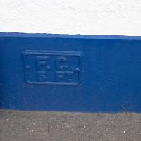
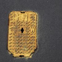
Which stands for Fire Cock. This is how they did fire hydrant symbols in the old days. There a modern fire hydrant 6 feet in front of this sign, as indicated. This little placard is on the front of the Britannia Buildings.
Swinging By Sydney Row
01 Apr 2021
Another workday, another quick coffee excursion. This time I decided to swing past Sydney Row on the way back from the marina car park where Imagine That have their horsebox. I didn't know until recently that the terrace was built for workers at the adjacent dockyard.
I've also gradually come to the conclusion that I don't really think very two-dimensionally when it comes to finding my way around or associating one place with another. I only realised in the last few days that the odd industrial building that takes up the other half of Syndey Row, the one that's always covered with graffiti, is the back of the dockyard works. In my defence, as it's tucked away in a corner of the little industrial estate that I've never ventured into (I rarely find I have a need for the products of safety valve manufacturers), I don't think I've ever seen the front of the building...
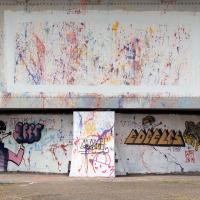
The pivot point of the Plimsoll Bridge is getting a lot of paint-based attention at the moment. Graffiti seems to be rife all round, in fact. I suppose there's not much else going on right now...
I noticed I'd missed a bit of Circular Road and Ladies Mile, and it was a nice evening for a sunset wander up to Clifton. There was something I recorded along the way, not photographically but in video.
Bristol Zoo, the world's oldest provincial zoo, has recently decided to close its Clifton site after 185 years of occupation, which means that the sounds of wild animals will no longer drift incongruously through this leafy Georgian area. They're moving everything up to their existing second site, The Wild Place Project near Cribbs Causeway. As I was wandering the Downs, I heard some fierce roaring noises, so I decided to see if I could get a little closer while they were still going on and record a sound that's soon to disappear.
I don't have a way yet to put video directly on this site, so here's a link to the video of my attempt to catch a bit of the zoo noises that I just popped on YouTube. It's sad that this might be the last time I hear such noises in Clifton.
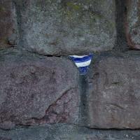
Is it still a potsherd if it's from a plate? (I just checked the dictionary, and apparently it is...) This one's embedded in a wall on Windsor Place.
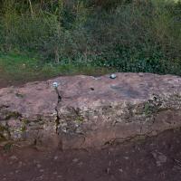
I wonder how many generations of mildly disreputable youth have got up to no good on this rock?
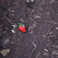
I was trying to find a way through to Observatory Hill via a different route from normal. Instead I found a corniche path with a somewhat vertiginous drop and... a strawberry. Presumably dropped from a picnic on the hill above...
An Evening Wander to the Gallows
06 Apr 2021
I'd originally intended just to pop up to the area around Alma Road, where I'd missed a few streets on earlier wanders. It was such a nice evening, though, I decided to extend my walk up to the very top of Pembroke Road, just outside my one mile radius, to take a few snaps of something intriguing I'd found in my researches.
I've driven, walked and jogged past the little triangle of land at the top of Pembroke road a great deal in my time in Bristol, but I didn't know that it used to be the site of a gibbet, in fact that the road itself there used to be called Gallows Acre Lane. According to the Durdham Down history trail, by Francis Greenacre (an excellent name for a Downs researcher!) among other sources:
...it was below this quarry near the top of Pembroke Road, once called Gallows Acre Lane, that a gibbet stood. It was sometimes occupied by those who had committed robberies on the Downs and was last used in 1783 to hang Shenkin Protheroe for the murder of a drover. Stories quickly spread that he descended from the gibbet at midnight every night and stalked through Clifton. Such was the alarm that his body was cut down and buried.
Also very close to this little triangle of land was one of the gates of the extensive turnpike system...
Anyway. Along the way I encountered a wooden tortoise and a real squirrel, among other things. It was a good walk, and more light in the evenings means I can move my wanders out of the ticking countdown clock of work lunch-hours and be a bit more leisurely.
Although the low sun was a bit annoying for some photos (and for walking directly towards) it did bring out some of Clifton's features very well.
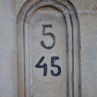
I wonder if this is another street that's been renumbered. It's 45 Apsley Road, but I guess this particular terrace (see next pic) might have had standalone numbering in the past.