Tagged: hotwell-road
I headed to Bedminster to do a crossword with my support bubble today. On the way I delved into a couple of bits of Hotwells history, first of all snapping a "now" shot to go with a historical photo of Holy Trinity I happened across recently, and second of all to snap the Britannia Buildings.
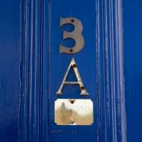
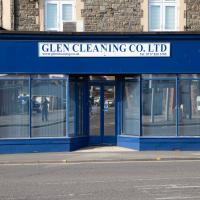
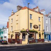
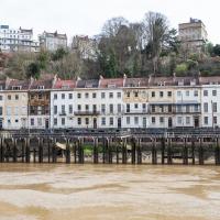
The Britannia Buildings are a little strip of offices on a corner of the Hotwell Road. They've mostly been the headquarters of a cleaning company for years, but I've often wondered what this distinctive curve of offices, its ground floor standing proudly out from the upper floors, used to be. Well, after my last wander, where I poked about the landing stage just down the road, I found out! Researching the paddleboat company P&A Campbell I came across this nugget in The A-Z of Curious Bristol, by Maurice Fells (£):
The firm of P & A Campbell was the main steamer operator in the Bristol Channel, with its local headquarters in offices close to the Hotwells pier and overlooking the harbour at the Cumberland Basin. Campbell's named their offices Britannia Buildings, after one of the ships in their White Funnel Fleet.
So! Turns out the Britannia Buildings were named after a paddle steamer—you can see some pictures of Britannia here.
In related news, I've now bought three of Maurice Fells' local history books, and they were hand-delivered by the author on Sunday, a half-hour after I ordered them online (through a message exchange on Nextdoor!) Not even Amazon Prime has managed to deliver me anything that quickly...
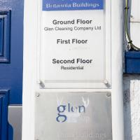
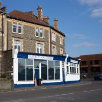
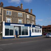
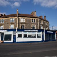
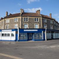
The Britannia Buildings were named for a paddle steamer in the P&A Campbell fleet, who used to have thier headquarters here.
There's some pictures of the Britannia, built in 1896, on the paddlesteamers.org site
Leigh Woods Walk
14 Mar 2021
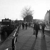
An enormous walk today, or at least it felt enormous. My feet are sore, anyway. I started off recreating a couple of local historical photos in Hotwells, but then headed for my traditional walk along the towpath in the Avon Gorge to the far extreme of Leigh Woods, up and through the woods to the height of the Suspension Bridge, finally crossing into Clifton Village for a well-deserved vanilla latte.
I say "traditional" because this used to be a very regular route for me, first walking, years and years ago, and later jogging—this route combined with a circuit of the Downs on the other side used to be my way of making sure I was fit to do a half-marathon (I did six of them in total, between 2010 and 2014).
I miss the routine of this walk, even though it's a long way and it used to pretty much wipe me out when I did it—I'd come back home and collapse and do very little for the rest of the day. But perhaps that's what Sundays are for, and I should try to remember that.
Doing this walk regularly was quite a meditative experience. Not so much of that today, but once I got to the further extreme of the towpath, where the roar of the Portway traffic on the other side of the river dwindles and I turned into Leigh Woods to climb ever closer to birdsong and further from rushing cars, I did seem to recapture a little of the feeling of previous walks. (I would say my mind cleared, but I was mentally singing along to Life Without Buildings' The Leanover for most of the wander. There are worse songs to have stuck in one's head, though; it's a great track...)
Anyway. Apparently the walk made me more likely to ramble in words, too. I'll stop now :)
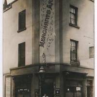
"Untitled. handwritten note on reverse 'Merchants Arms, Merchants Road, Hotwells. Licencee 1912 Mrs Florence Norris (over right hand door)'"
Sadly closed for lockdown at the moment, of course. Hopefully they'll weather the storm, because it's a great little pub and it's been there since at least 1847.
Photograph by L. Worsell, Bristol. Courtesy Bristol Archives/The Vaughan Collection
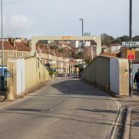
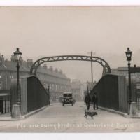
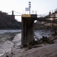
I'm not sure what the cross-beam over the top with the height restriction on is called, but I much prefer the original one. Although the bridge is very utilitarian in looks, anyway.
I love the terracing between the back of Rock House/the Colonnade and the heights of Clifton
Mardyke then and Now
18 Mar 2021
Reproducing historical photos seems to be a developing interest for me. On today's wander I just went for my normal coffee at Imagine That, but along the way I stopped at Baltic Wharf (the modern housing estate; historically-speaking, I was probably in between Canada Wharf and Gefle Wharf—about here, in fact) to reproduce a 1930s photo of the Mardyke area from the Tarring collection.
Mardyke, from what I can work out, means "a ditch along the margins". Before my researches, I only really knew the name from the Mardyke pub, a big place on the Hotwell Road. Everyone knows the Mardyke, partly because of its size and signage, but I've only been in once or twice, too long ago to remember much of what it was like. However, the wharf there used to be known as Mardyke Wharf, and the area in general as Mardyke. (I just found an 1826 painting by Thomas Leeson Rowbotham of "Mardyke seen from near Hilhouse's Dock, showing the 'Clifton Ark' floating chapel" that shows the area before much development had happened, incidentally, and now I feel like I need to find out a bit more about the floating chapel...)
I enjoyed snapping the "after" photo; the process involved moving a group of swans out of the place I needed to stand to get the photo; luckily I've started carrying waterfowl food along with my on my harbourside jaunts, so I could use bribery rather than a more confrontational approach. Not sure I'd fancy my chances against a swan, though I did once team up with another passerby to shoo a recalcitrant one off the Redcliffe bascule bridge so a busful of commuters could continue their journey to work...
Via Know Your Place Bristol/the Tarring Collection.
The Mardyke area—apparently Mardyke means a dyke on the margins, which would make sense for the location—in the 1930s. That's got to be a Campbell paddle steamer from their White Funnel fleet, but I don't know which one. Looks to be a similar configuration to the Princess May, though the paddles look a bit different. In the background, the Mardyke Pub still stands today, but the three largest buildings do not. They are:
Top right: the Clifton National School (there's a Loxton sketch uploaded to this Wander where you can see the name on the front.)
Directly in front and below the Clfiton National School, on the main Hotwell Road: The Clifton Industrial School, Mardyke building.
Standing halfway up the hill, more towards the middle of the picture: the Clifton Industrial School, Church Path Steps building.
Lots of info to be found on the Industrial Schools here:
In addition to their classroom lessons, the boys were employed in tailoring, shoemaking and brush-making, with basket making later added. The boys also assisted with the kitchen, laundry, and house work. In 1870, some additional rooms were rented in the locality for use as an infirmary if required. A School band was established.
I can't find so much on the National School (though apparently the Bristol Archives have some of their records) but the Clifton & Hotwells Character Appraisal suggest it was built in 1835 and, along with the Industrial School buildings, destroyed during WWII:
A bomb also largely destroyed the Clifton National School and Mardyke House School. The lack of bomb- proof shelters in Clifton led to the Clifton Rocks Railway to be used as shelter, which was prepared for occupation in 1940.
Showing both the Clifton Industrial School on the Hotwell Road, and the Clifton National Schools building on the hill above.
(via the Loxton Collection from Bristol Libraries on Flickr.)
The colourful modern flats stand on School Road, presumably the last hint that the Clifton National Schools building was there before. It's nice to see both the Mardyke Pub and some of the ordinary houses from the terrace dead centre still there and looking much the same.
Quick Around-the-Harbour Wander with Lisa
20 Mar 2021
My friend Lisa was meeting another friend for a walk near the suspension bridge, so we fitted in a quick harbourside loop from my place first. We discussed gardening (we're both envious of the gardening skills of the Pooles Wharf residents; we can just about keep herbs alive, whereas they're growing heartily-fruiting lemon trees outdoors in England along with everything from bonsai to magnolias), cafes, work and architecture, among other things.
This was one of the details I used to line up my "after" pic of Mardyke with the 1930s "before" pic on my last wander.
I wasn't going to take a very long walk on this nice spring evening; it just happened. I was going to knock off a path or two on Brandon Hill, home over centuries to hermits and windmills, cannons and Chartists, and then just wander home, stopping only to fill up my milk bottle at the vending machine in the Pump House car park.
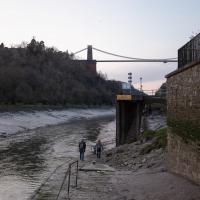
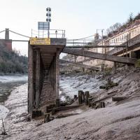
However, when I heard a distant gas burner I stayed on the hill long enough to see if I could get a decent photo of both the hot air balloon drifting over with Cabot Tower in the same frame (spoiler: I couldn't. And only having the fixed-focal-length Fuji with me didn't help) and then, on the way home, bumped into my "support bubble", Sarah and Vik, and extended my walk even further do creep carefully down the slipway next to the old paddle steamer landing stage and get some photos from its furthest extreme during a very low tide...
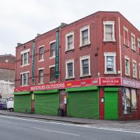
I've bought many things from Marcuss over the years. A pair of secondhand German para boots got me started, I think, and I've bought snowboarding gear, camping gear, winter coats and sundry other things like the Opinel No. 06 knife I use for hunting and skinning the geek's natural prey: Amazon parcels.
I got interested in Bristol's medieval water supplies after poking around near Jacobs Wells Road and Brandon Hill. It was during that research I found out about a pipe that's still there today, and, as far as I know, still actually functioning, that was originally commissioned by Carmelite monks in the 13th century. They wanted a supply of spring water from Brandon Hill to their priory on the site of what's now the Bristol Beacon—Colston Hall, as-was. It was created around 1267, and later, in 1376, extended generously with an extra "feather" pipe to St John's On The Wall, giving the pipework its modern name of "St John's Conduit".
St John's on the Wall is still there, guarding the remaining city gate at the end of Broad Street, and the outlet tap area was recently refurbished. It doesn't run continuously now, like it did when I first moved to Bristol and worked at the end of Broad Street, in the Everard Building, but I believe the pipe still functions. One day I'd like to see that tap running...
There are a few links on the web about the pipe, but by far the best thing to do is to watch this short and fascinating 1970s TV documentary called The Hidden Source, which has some footage of the actual pipe and also lots of fantastic general footage of Bristol in the seventies.
On my walk today I was actually just going to the building society in town, but I decided to trace some of the route of the Carmelite pipe, including visiting streets it runs under, like Park Street, Christmas Street, and, of course, Pipe Lane. I also went a bit out of my way to check out St James' Priory, the oldest building in Bristol, seeing as it was just around the corner from the building society.
There are far too many pictures from this walk, and my feet are now quite sore, because it was a long one. But I enjoyed it.
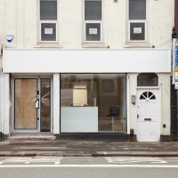
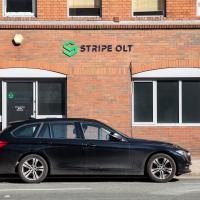
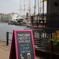
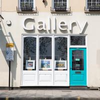
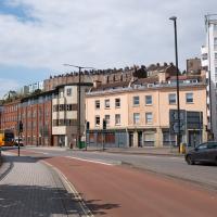
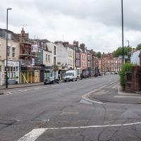
Looks like something's getting spruced up ready for opening. Good. This bit of the Hotwell Road needs some nice new shops, of any and all varieties.
This place was joined up with the shop to the left as a hot tub sales showroom, and before that it was the View art gallery. Before that it was a brothel for a while, oddly, but I think the general community reaction was a bit too hostile for it to survive. Looks like it's now been separated from the next door shop.
Man on a Mission
17 Apr 2021
I went rather outside my area today, as I went to pick something up from the Warhammer shop on Wine Street (Games Workshop as-was, and before that I think perhaps a rare retail outlet for Her Majesty's Stationery Office? I may be mis-remembering...) Anyway, a friend of mine wanted something picking up and posting to him, so I figured I'd knock some streets off my list along the way.
I first headed for the St George's Road area, walking down the narrow Brandon Steps and finding some strange wall art on Brandon Steep, then headed to the Old City via Zed Alley. The Warhammer shop visit was friendly and efficient, and, mission accomplished, I treated myself to a sausage roll and a flat white from Spicer + Cole, to take away and eat in Queen Square with its current decoration of hearts. I finished off with a detour up Park Street, looking out for St John's Conduit markers, before finally crossing Brandon Hill on the way home.
Quite a long wander, all told, and I'm a bit knackered today...

When you think you're a free spirit who needs a convertible when actually you'd have been better off with the Volvo estate.
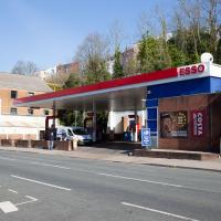
Who was it that decided that petrol stations had to be ugly? It's not like oil companies don't have money...
Apparently they're a "Cloud and Cyber Security Specialist". Let's not let them near this website, please; I wrote a lot of the code in a hurry when I was tired...
A New Wander, a New Cafe
21 Apr 2021
Obviously, I was trying to connect to the industrial history of the Canon's Marsh area, to the old gasworks, the docks railway, the warehouses they blew up to make way for all the rather soulless modern stuff (though I do like the Lloyds building, at least.) But what I mostly got out of today's walk is a new cafe to go to for my lunchtime outings. It's perhaps a little closer than both Imagine That and Hopper Coffee; not quite as close as Foliage and Twelve up in Clifton Village, but also not at the top of a steep hill.
No, not the mediocre Costa, but only a little way away from there: Rod and Ruby's, which opened in 2018 and which I've seen in passing several times but never popped into until today. What can I say? I was foolish. Great flat white, lovely interior, astoundingly good cannoli.
Sometimes you just have to get your head out of history and enjoy a pastry.
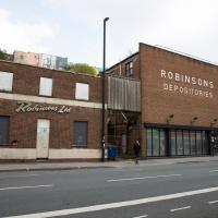
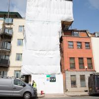
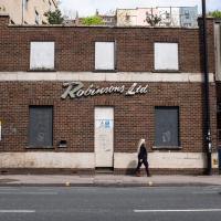
I know very little about the history of these buildings. There's a removals firm called Robinsons with some links to Bristol, and a building in Brimingham with an old sign saying "Robinsons Furniture Depositories", so I suppose it's possible this is a long-defunct furinture repository for a removals firm. Last planning application I can find is from 1998, before I even moved to Hotwells, granting permission to demolish "two storey office building and single storey store", which very much sounds like these two buildings.
The bit on the right still has a sign up saying it's Gnodal and Bioinduction—the firms whose car park is around the back—though Gnodal is defunct and Bioinduction sadly don't have any pictures from the Bristol office on the one-page website.
I really must poke my nose in and see if there's anything more than the apparently-tiny couryard back there.
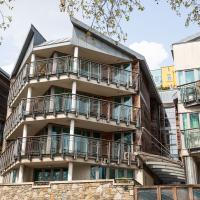
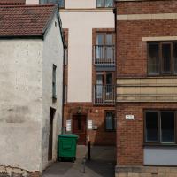
I actually quite like this one, especially the pointed fronts of the living spaces. Decent size balconies, too.
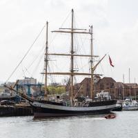
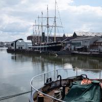
Formerly an arctic trawler, built in Le Havre1, now a sailing trainer.
1 [Great film](https://en.wikipedia.org/wiki/Le_Havre_(film)), by the way, and also an [interesting city with a real architectural heritage](https://en.wikipedia.org/wiki/Le_Havre) that I'd like to see some day...

Canons Marsh Coffee Trip
29 Apr 2021
Another quick excursion to Canon's Marsh, tempted back by Rod & Ruby's cannoli and flat white. This time I poked around some bits of the modern flats I'd not really experienced before, mused on the old gasworks, and headed back down the Hotwell Road, spotting a re-opening gallery and finishing off at the Adam & Eve, for which some locals are currently rushing to launch a bid to turn it into a community business rather than have a developer turn it into yet-more flats.
I was in a bouncy, positive mood, helped out by Life Without Buildings' Live at the Annandale Hotel album1. Note to self, though: the album is nearly an hour long, so if you hear the encore starting and you're still halfway down the Hotwell Road, you'll probably be late back from lunch...
1 That review's well worth a read. Music journalists tend to go extra-dreamy when trying to describe Sue Tompkins. See what I mean:
She circles her limber tongue-twisters, feints, and attacks from unexpected angles, dicing and rearranging them with the superhuman brio of an anime ninja and a telegraphic sense of lexical rhythm.
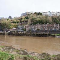
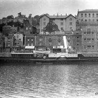
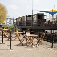
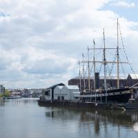
This is the stern of MV Balmoral, previously owned by P&A Campbell, the steamship operators, who I've mentioned once or twice before.
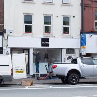
This (and I think the place next door, too) used to be the View Gallery; from the looks of the new sign it's becoming the View Gallery again. Good. Hotwell Road needs a bit of regeneration.
Library, Bookshop, Coffee
03 Jul 2021
I was headed into town to return RA Gilbert's biography of AE Waite to the library and along the way I noticed that Dreadnought had finished their refurbishment, but wouldn't be open until midday. That left me some time to kill, so I bimbled around the old St Augustine's/Gaunt's area for a while, then headed up Park Street for a coffee and a snack to eat on Brandon Hill before heading home the way I'd came so I could pop in and buy a pamphlet on the Hot Well I'd been interested in for a while.
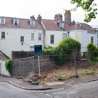
According to the listing, this plot has:
PLANNING GRANTED to erect a DETACHED MEWS HOUSE ( 1743 Sq Ft ) with GARAGE and courtyard garden.
Looks a bit of a tight fit, but it's a nice location and there are very few small whole houses in my neighbourhood, especially not modern ones. Round here it's mostly grand old Georgian stock that's been chopped up into flats, and even the "modern" blocks are getting on a bit.
Location-wise it might be a fair bit noisier than my place, because it's closer to the Hotwell Road and would also instantly become the closest house to Hotwells Primary's playground. On the other hand, unlike my listed building, you'd actually be able to have double glazing and there wouldn't be any immediate neighbours on any side...
I'll be interested to see what the price is like when it eventually gets built.
Up until recently it was just used as an off-street parking spot and always looked rather run-down, so I'm generally in favour of replacing it with a small house.
I imagine this is the house whose owners also own the plot with planning permission; it seems to be the end of their back garden.
These nearest houses were originally called Chapel Row; they're an extension of the western end of Dowry Square, built 1725-1727. Most of the houses in this area were built from the 1720s onwards as the popularity of the Hot Well caused a demand for lodging space closer than College Green, where people generally stayed before.
Number 262 here, the closest, is presumably owned by the same people who own the little plot of ground that's for sale, given that it's basically at the end of their back garden.
It was called Chapel Row because a chapel used to stand in the middle of this terrace, long before Carrick House was built at the far end.
On the ever-helpful Church Crawler you can see some pictures of the original chapel Dowry Chapel, and its successor, St-Andrew-the-Less. St Andrew (-the-Greater) was of course St Andrew's in Clifton Village.
Pevsner apparently said of St-Andrew-the-Less:
is an unforgiveable crime against the architecture of Dowry Square and chapel Row. Of no value either in its own Gothic forms. The spire is particularly nasty.
Personally, I thought it looked rather nice, but I'm used to Bristol's jumbletechture. It definitely lasted until c. 1963 as there's a picture of it around then (in the background of the devastation wrought by the demolition to clear the way for the Cumberland Basin Flyover System) in Hotwells - Spa to Pantomime.

I think that's what these are, anyway. Erigeron. They cheer me up every time I walk past Holy Trinity at this time of year.
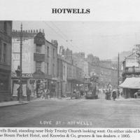
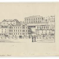
Circa 1905. See the previous photo for the modern-day version. Several of the houses on display were destroyed during the blitz of 24 November, 1940.
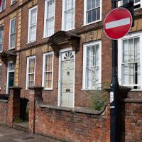
I'd never heard of this being called Love Street before. It does seem that it was, though: I just searched through all the various digital research materials I've gathered during this project and found this tidbit in A Bristol Miscellany:
It is proposed to drain the whole of this district by means of a low level sewer commencing at the bottom of Woodwelllane or Jacobs Wells road nearly opposite Woodwell crescent passing along the whole length of the Hotwell road and Love street to Dowry square continuing along in front of Dowry Parade and the Gloster Hotel passing the bottom of Granby Hill in front of Ashton place to Saint Vincent's Parade at which point it will receive the sewage from the Royal York Crescent, the West Mall and Caledonia Place, from which point it will continue along in front of Hotwell House underneath the rocks to the towing path in front of Point House at the Round Point to the present outlet of the High Level Sewer District being about 1,100 yards below the Hotwell House.
...but no other mentions than that one. Looking around the web, I can see a few more references, including this delightful business card for Hotwells gardener John Waldron.
I did idly wonder if "Love Street" might've been a euphemism for something, at some point? There were an awful lot of sailors coming off boats nearby! But perhaps it was simply a nice name for a nice stretch of road...
Photo from Hotwells and the City Docks, ISBN 9781899388288
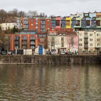
At what was apparently, at some point, called Love Street, but is now just another section of Hotwell Road. See next picture for the c. 1905 view and more information on "Love Street".