Tagged: hotwell-road
Lunchtime Zig Zag Climb
13 Jul 2021
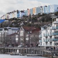
A snappy little trip up the Zig Zag to the shops. It's a steep old route, the Zig Zag, going from just over river level to about the height of the suspension bridge (101 metres) in a compact switchback of a footpath.
I was too busy struggling to breathe to take many snaps of the actual Zig Zag (I've been trying to make it up all the way without stopping the last few times, but I've not quite managed it yet). I did at least take a few snaps either side on this quick lunchtime jaunt to fetch coffee (Coffee #1) and a sarnie (Parsons) from Clifton Village...
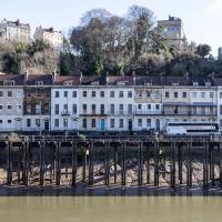
But I don't think it's the original end -- if you check this picture from a history pamphlet I posted on Twitter you'll see that it looks like the Colonnade used to curve around rather more, and there's an even better view on this drawing from the British Library collection of Hotwell Parade. Looking at the historic basemap layers there on KYP it certainly seems like sometime between 1855 and 1874 (both Ashmead maps) the first couple of houses in the terrace were lopped off, leaving only numbers 3, 4, 5 and 6. I imagine they were shaved off at the same time as the second Hot Well House was demolished, which was in 1867. It used to stand on Hotwell Point, sticking out into the river, and the whole lot was removed to ease navigation.
I've never actually looked at the Colonnade door numbers to see if they're still like that—I'll try to remember the next time I pass.
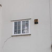
I will always enjoy the fact that Brunel looks out from this window. Have I ever noticed the smaller figure in the lower-left corner? Maybe it's new...
A Morning of Research and a Cafe in a Castle
25 Sep 2021
I needed to pop to the library, as they'd kindly dug a book out of the reserve store at the B Bond warehouse for me and emailed me to let me know it was ready. So, I took a little trip to town, straight down the Hotwell Road, and spent a few hours reading before stretching my legs with a walk to a new cafe in the actual castle (or remnants thereof, anyway) of Castle Park, before heading back home down the other side of the harbour. As well as books and coffee, I bumped into a remote-controlled pirate ship, which isn't something you see every day, even in Bristol.
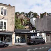
Have I ever looked up and noticed the view above Western Car Radio, which looks like perhaps the terraced back garden of St George's Primary? If I have, I don't seem to have snapped it before.
There are some unexpected links between Triodos Bank and some of the magical stuff I've been researching. I first found out when I checked the upcoming events at the Bristol Theosophical Lodge and saw a director of the bank would be giving a talk there. Apparently the bank is rooted in the ideas of Rudolf Steiner's anthroposophy. The Guardian says:
Its roots (like the UK bank Mercury Provident, which it took over in 1995), are in the anthroposophy movement. This refers to the ideas of the Austrian spiritualist thinker Rudolf Steiner, who died in 1925 and whose interests included education, 'biodynamic' agriculture, eurythmy (movement as art) and therapeutic medicine.
Triodos Bank's statutes committed it to anthroposophical principles until 1999, when this formal link was dropped, and in recent years the bank, under its current head Peter Blom, has embarked on a policy of reaching out beyond Steiner adherents and of broadening its appeal. Nevertheless, Triodos's origins are reflected in the fact that most of the Dutch directors come from within anthroposophy, and it is banker for many Steiner-inspired projects.
The more I research it, the more I find that Hotwells had far better transport links back in Victorian and Edwardian times than it has today. Along with buses that went to more useful places than the City Centre, there were trams, the funicular up to Clifton, the landing stage for paddle steamer services and two railway stations all within easy walking distance of me.
Today I took a day off work as preparation for doing the bookkeeping for my tax return1, and took a wander along to the site of what would have been my nearest station, Hotwells (or Clifton, as it started out in life), nestled in the shadow of the suspension bridge, the Bristol terminus of the Bristol Port Railway and Pier.
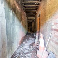
From there I wandered down the Portway, following the original line, until I got to the area around Sneyd Park Junction, where the tunnel from the slightly later Clifton Extension Railway joined up with this originally-isolated BPR line. Then I headed up to Clifton through the "goat gully" at Walcombe Slade, seeing the few above-ground bits of evidence of the tunnel (which is still in regular use) along the way.
It was a lovely day, and a good walk, and it was interesting to daydream of the times when I could have walked a few minutes from my flat down to Dowry Parade, caught a short tram ride to Hotwells Stations, and then headed from there to Avonmouth, perhaps even to board a transatlantic passenger service. The completion of the Clifton Extension Railway that linked the Avonmouth station with Temple Meads made relatively direct transatlantic travel from London via Bristol possible, with passengers travelling up from Paddington to Temple Meads, on to Avonmouth on the Clifton Extension Railway and Port Railway and Pier line, then perhaps catching a Cambpell's paddle steamer—which sometimes acted as tenders for large steamers—to a larger ship that was headed out for Canada, say.
1 I've learned that the best approach is to take two days off and deliberately do something that's not my bookkeeping on the first day, as otherwise I just inevitably end up procrastinating and feeling guilty on the first day no matter what. I have an odd brain, but at least I'm learning strategies for dealing with its strange ways as I get older...
2 Information mostly gleaned from Colin Maggs' The Bristol Port Railway & Pier and the Clifton Extension Railway, The Oakwood Press, 1975.
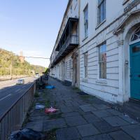
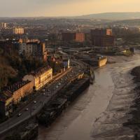
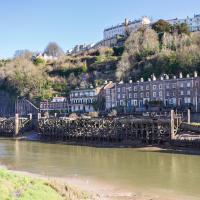
St Vincent's Parade looking a bit more run-down than normal. This street, like the one I live in, was built as lodging houses for visitors to the hot wells. I imagine it was quite a pleasant aspect before later developments like the building of the Portway.
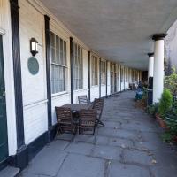
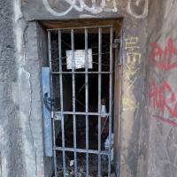
I didn't go inside, just shot through the gate with a steady hand. I have been in there, though, on one of the open day tours.
From The Bristol Hotwell, by Vincent Waite, ISSN 1362 7759, Bristol Branch of the Historical Association, 2002 reprint.
...in 1867 the new Pump Room was in turn demolished so that Hotwell Point could be removed and river navigation made safer. Thus the spring was lost after a long and eventful history. After much public agitation and complaining in the local press the spring was enclosed and piped to a small grotto hollowed out in the rock. Here a pump was set up in 1877 and an attendant provided by the Bristol Docks committee. In 1880 Dr. Griffin wrote a warning letter to the newspapers claiming that his analysis of this pump water proved that it was not from the original spring which in any case was too far away to retain its correct temperature. Yet up to 1913 the pump was still in use, and sometimes supplied as many as 350 persons a day. Then the long-threatened pollution of the water by the river became too obvious to be ignored and the pump was closed. The entrance, blocked up by a small wooden door, can still be seen in Hotwells Road near the Suspension Bridge.
The wooden door is no longer here, but this is definitely the place.
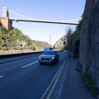
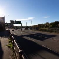
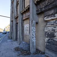
One of the many problems with the Hotwell Road and Portway is the complete dearth of places to safely cross this road, with a varying number of lanes and a speed limit that hits 50mph for stretches.
You can stand for a very long time looking both ways before taking your life into your hands and scurrying across. It took me quite some time to dash to the other pavement at the point where this one runs out and your only choice is to head up the Zig Zag or cross.
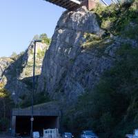
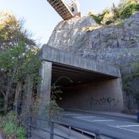
It's a (glass-fibre reinforced, I think) concrete roof to keep falling rocks from blocking the road at this particularly friable bit of the cliff face.
A Water-Based Wander
11 Dec 2021
I woke up on this Saturday with a headache, feeling like I'd not slept at all. As well as that, I'm still in some pain from the wisdom tooth extraction I had a few weeks ago. I moped about the flat for a while and then decided that the best thing to do was to force myself out on at least a small walk to get some fresh air and coffee.
Was there anywhere I could walk locally that I'd never been? Actually, yes! Although it's not a road, and I didn't walk it, there is actually one route that I've not travelled so far in my wanders. And it even had coffee near its far end...
A Constitutional to Burwalls and Back
21 Dec 2021
The recent lack of posts here is mostly due to my feeling very run down following having a couple of wisdom teeth extracted. Having had an emergency appointment yesterday1, hopefully I'll be on the mend now, though it does mean I'm on the kind of antibiotics where you can't touch alcohol for the whole of the Christmas period. I have tried to keep myself a little distracted from the pain by working on the nuts and bolts of this website—you should notice that the front page loads rather faster now than it used to, and that there's a shiny new statistics page that I'll probably be continuing to work on. Oh, and you should find that the tags below the photos are now clickable and will take you to a page of all other wanders that have photos with the same tag.
Today I felt like I needed to drag myself out of the house, but I didn't want to go too far, and I needed to get to the Post Office up in Clifton Village to post a Christmas card (spoiler for my parents: it's going to be late. Sorry.) As luck would have it, idly looking at the map I spotted that I'd missed off a section of Burwalls Road in the past, and that's basically one of the long-ways-round to Clifton Village, crossing the river to Rownham and walking up the hill on the Somerset side before coming back across the Suspension Bridge.
As I was heading for Burwalls Road I decided to make Burwalls itself the focal point of the walk, but unfortunately the mansion grounds are private and the place is hard to snap. Still, at least it gave me a destination. Burwalls was the mansion built by Bristol press magnate Joseph Leech, who I've mentioned before after buying a vintage book he wrote on a previous wander. There's a good article about the house on House and Heritage which has some photos from angles I couldn't ever get to. (Well, maybe with a drone, but it seems like the kind of area where they may be kitted out for clay pigeon shooting, so I probably wouldn't risk it.)
1 My dentist admitted that she probably needed to keep her internal monologue a bit more internal after we started the appointment with her staring into my mouth and immediately saying, "oh, *that's* weird." These are words one doesn't want to hear from a medical professional.
Technically that's still actually the Hotwell Road down there, and it doesn't become the Portway until the Bridge Valley Road junction, but I needed the alliteration, okay?
This is the kind of photograph that I really like, but is harder to find appreciation for these days—the Panavision aspect ratio I've chosen, 2.35:1, doesn't play nicely with today's standard media consumption device of a mobile phone held in portrait orientation. Maybe one day we'll all be using the internet through VR headsets and landscape orentation will make a comeback.
Lunchtime Reproduction (of an old photo...)
17 Jan 2022
This was basically the quick lunchtime jaunt I tried to do at the beginning of January, only this time I actually managed to get to roughly the viewpoint I'd been hoping for to recreate a historical photo of the Bristol International Exhibition.
I did this walk about a month ago, but I've been a bit poorly and not really up to doing much in my spare time, and it's taken me this long to even face processing even these few photos. Hopefully normal service will be resumed at some point and I can carry on trying to walk any roads and paths that I need to do to make this project feel complete...
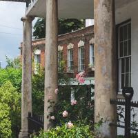
The Colonnade, the Rock House, St Vincent's Parade and the old landing stages for Campbell's paddle steamers. The leftover fruit of bygone boom years.
Bedminster Trip for New Walking Shoes
26 Feb 2022
I needed to buy new walking shoes—my old ones were squeaking and it was driving me up the wall—so I ordered some for collection from Taunton Leisure on East Street in Bedminster, and decided to make picking them up an official wander.
I didn't cover any new ground within my mile, but I did take advantage of the trip to take in a few interesting things just outside my normal radius, mostly New Gaol-related. Along the way there are a couple of sanitation-related diversions, including a visit to a rare manhole cover. You can hardly wait, I can tell!
In Which We Begin and End with Love
05 Mar 2022
I had a lot to get done around the house, so as soon as I heard there might be a shiny new piece of street art near me, under the Cumberland Basin flyovers, I immediately decided that was all the excuse I needed to set off on a round-the-harbour lunchtime walk to get some fresh air and see if I could spot it. So, here's a circular wander that takes in graffiti, boats, wildlife and graffiti again...
Leigh Woods Purple Path
12 Mar 2022
There's a few tracks in Leigh Woods that lie within my mile and show up on my map but that I've not walked yet, so I decided to take one of my traditional big long walks through the woods on this nice crisp sunny morning.
For years—decades, even—I've been doing a similar route from my place, along the towpath to the far woods entrance, up the hill for a varied walk on one of the marked tracks and then across the Suspension Bridge to Clifton Village for a coffee-based reward. It's my default "long walk", really, and I almost always enjoy it. Today, at last, spring actually seemed to be springing, which made for some extra positivity...
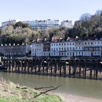
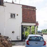
I've always enjoyed the optical illusion that these houses are on stilts from this angle. In fact there's the Hotwell Road the National Express coach is on in between the houses at the back and the disused landing stage at the front, as you'll see in the next pic of the adjacent terrace.
The Campbell Brothers' White Funnel Fleet operated from the Hotwells landing stage up until relatively recently. Last week I bought an old timetable on eBay and popped it up on my blog for anyone who might be interested.
In 1965, the year of the timetable, there were regular sailings from here along the coast or over to Wales. You could go to Ilfracombe and Lundy Island, or head across to Barry, Penarth or Cardiff. All from within five minutes' walk of my front door.
I noticed I had a few things on my "potential wanders" list that could all be done relatively close to home, and in a fairly straight line, so I set off at lunchtime to recreate a photo of a now-defunct pub, wander behind a Spar (which turned out to be more interesting than I'd expected, but I admit it's a low bar) and spend some time browsing in Dreadnought Books before coming home via a coffee from Spoke & Stringer, a little diversion up Gasworks Lane and a tiny bit of the Rownham Mead estate I'd somehow previously skipped.
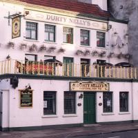
Uncredited apart from "from our archives" and undated, this photo appeared in this article on Hotwells in the Evening Post and made me want to re-create the same view today.
The pub had a few changes of name over time—in the Bristol Then and Now Facebook group people recall this being the Spring Gardens in the 1950s, 60s and 70s. Someone remembers it turning into Durty Nelly's in 1995, but I swear it was back to being the Spring Gardens again by the time I moved to the area in 1999. Then it spent some time as La Demi Lune, which you can see on Street View in 2008, and then by 2009 it's back to The Spring Garden (without the "s").
So, from what I can work out, this snap was probably taken in the 1990s, most likely between 1995 and 1999.
This pub—which did good food, and had an extensive garden at the back, from what I remember, when it was the Spring Gardens in the early 2000s—is rather more bland in looks today, as we'll see in the next picture.
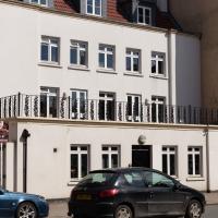
Here's the Spring Garden(s)/Durty Nelly's/La Demi Lune as it looks today. Rather dull modern accommodation, sadly. I understand they may have extended the building back into the garden to make it roomy enough to be flats.
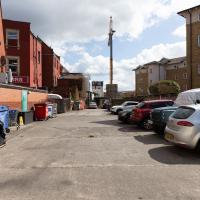
Here we are at the end of Pembroke Place, wandering a little alleyway I'd not previously filled in on the map. I didn't have high hopes for much of interest in this parking area behind Spar and Marcruss Stores. However, I did find something interesting, as we'll see in a couple of photos' time.
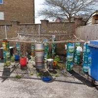
I can only guess that the Raj Bari restaurant has been trying to grow their own herbs and spices. Doesn't look that successful at the moment, to be honest, but maybe I'm looking at things that aren't in season...
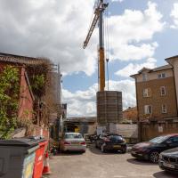
Not much to be seen in this direction except the crane on the site where they're busily filling a gap with new flats. We'll see the front in a little while.
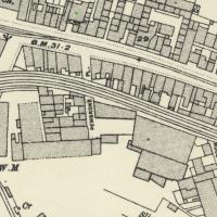
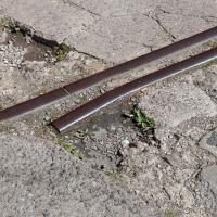
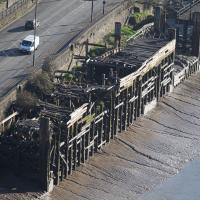
On Know Your Place you can check out old maps of Bristol. Sadly there doesn't seem to be an easy way of linking to a particular map/location. Still, here's a little screenshot of the 1898-1939 layer. These tracks are still there on the later 1949 map, so at least this section survived the war, I think.
Having checked Wikipedia I think this section, which ran from Canons Marsh to Ashton Avenue Bridge and then on to the south was created in 1906, and closed in 1965.
This map fragment will be © Ordnance Survey.
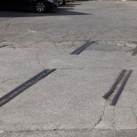
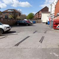
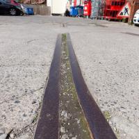
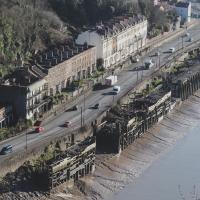
Remnants of the docks railway. These ran around the harbour to Ashton Avenue Bridge to the west, and along to the main Goods Depot at Anchor Lane to the east.
I think this may be the last visible remnant of the harbour railway on this entire stretch of the Hotwell Road. There may still be some tracks around Canons March—that whole area south of Anchor Road had a lot of rail lines—but I've not seen any others west of Jacobs Wells Road.