Tagged: river-avon
A London Wander in Southville
10 Apr 2021
There's a bit of Southville that I've been meaning to get to for some time, where the streets seem to take some strong inspiration from London. There's a Camden Road that crosses with an Islington Road, and a Dalston Road, even an Edgeware Road. For me these names are more evocative than the rather more exotic names I passed by to get there—Sydney Row or Hanover Place, say, because I've actually been to the places in London. The last time I was in Islington I saw Monkey Swallows the Universe play at The Angel, and I can't think of Camden without remembering a gondola trip with my friend Tara where a cheery youth played Beatles music for us on a saz...
I really liked this little area, with its mostly well-kept pretty houses and hints here and there of the creative side of the residents. It's arty and down-to-earth at the same time, and I wouldn't mind living there, I think.
On the way there I got the chance to walk through Underfall Yard for the first time in a while, and on the way back I had my first take-away hot food for many months, grabbing some crispy fried squid from the excellent Woky Ko at Wapping Wharf.
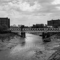
Howard's Lock
27 Apr 2021
Bits of Entrance Lock have been coned off for ages, mostly the area with the lockkeepers' house on it. My friends Sarah and Vik mentioned at the weekend that it had recently been un-coned, so I wandered that way to cross the outermost lockgates for the first time this year. I don't know whether it's just my mood today or the weather, but it seemed a day for pushing a couple of photos in a more experimental direction in the post-processing...
Another Day, Another 50 Metres
29 May 2021
I met my friends Sarah and Vik at Riverside Garden Centre today; I needed to buy some compost for repotting my wildly-overgrowing aloe vera, and I went a little bit out of my way to knock off a stretch of Ashton Road. It was a pleasant enough walk in the surprisingly warm (and surprising-not-tipping-it-down-on-a-Bank-Holiday-weekend) weather.
Leigh Woods Solo
19 Jun 2021
I hadn't really planned to go out for a wander yesterday; I just got the urge and thought "why not?" (Well, the weather forecast was one possible reason, but I managed to avoid the rain, luckily.)
I wanted to finish off the A369—as it turns out I may still have a small section to go, but I've now walked the bulk of it out to my one-mile radius—and also a few random tracks in Leigh Woods. I'm still not really sure that I'm going to walk them all, especially after discovering today that "the map is not the territory" applies even more in the woods, where one of the marked tracks on the map wasn't really that recognisable as a track in real life... I'm glad I'd programmed the route into the GPS in advance!
Anyway. A pleasant enough walk, oddly bookended, photographically at least, by unusual vehicles. Leigh Woods was fairly busy, especially the section I'd chosen, which was positively dripping with teenage schoolkids with rah accents muttering opprobrium about the Duke of Edinburgh. I'm presuming the harsh remarks were more about taking part in his award scheme than the late Consort himself, but I didn't eavesdrop enough to be certain...
I took this as a comparison shot for this non-OMM photo I snapped the other night, to show how much difference the right conditions can make to a photograph :D
Shops, Hedgehogs and Cows
06 Jul 2021
I really only took the GPS and camera on a "just in case" basis, as I knew I was only going for a coffee in Greville Smyth Park along a well-trodden path this lunchtime. Still, I saw a few new things along the way, so I figured it was worth uploading the handful of photos I took...
Pastures New!
17 Jul 2021
Okay, not much in the way of actual pasture to be had in Bedminster these days, like most of Bristol, but I did take advantage of the current rather toasty weather in Bristol to go and sit under a tree in Greville Smyth Park to read a book for a while before firing up the GPS and taking a little detour around some back streets of Ashton and Bedminster rather than going straight to Coffee #1 for an espresso frappé. This is the first walk in a while where I've actually crossed off an entire new street (the frankly unexciting Carrington Road) as well as exploring a couple of back alleys, just because they were there, really. Along the way I spotted a few examples of graffiti of various qualities, including a live work-in-progress by SNUB23 on Ashton Road and the finished Six Sisters project on North Street.
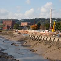
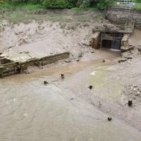
They've not made much progress on repairing the Chocolate Path, sadly, but it seems they've at least got a budget and a green light now.
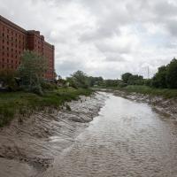
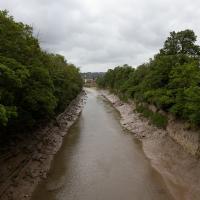
The entire New Cut only took five years to dig out, but on the other hand they had literally a thousand men on the job and I imagine several of them died. Probably have to be a bit more careful these days.
A Journey to the Far East
25 Jul 2021
The far east of the intersection of my one-mile radius and Bedminster, anyway. I was feeling a bit tired this morning, so I motivated myself to get out of the door by imagining one of Mokoko's almond croissants. That got me on my way, and I wandered across to Bedminster, through Greville Smyth Park, along most of the length of North Street (looking out for new Upfest 75-pieces-in-75-days artwork as I went) and then onto some new roads at the far end.
I only wanted to knock a few streets off my "to do" list, but by the time I'd diverted here and there to check out various bits of graffiti and other attractions and come back via the aforementioned purveyors of Bristol's finest croissants, I'd walked 7.4km. Not bad for someone who woke up tired, and at least I've done something with my day. I'm very glad the weather broke (we had tremendous thunderstorms yesterday), even if some of the pictures might've looked better with a blue sky. I was getting fed up with walking around in 29°C heat...
A Long Wander Of Miscellany and Magick
08 Aug 2021
This was a wide-ranging wander. I started off crossing the river to Bedminster, to walk a single little cul-de-sac, Hardy Avenue, that I'd managed to miss on at least one previous walk. Then, pausing only to explore a few back alleyways, I headed for a few destinations related mostly by the Hughes family, who I've been researching a little as part of background for a possible novel, as several of them were involved in the Stella Matutina.
However, mostly it's the artistic side of the family I wanted to explore today, as that's where most of their public history lies (as you might expect, there's often not much in the public record about the workings of an occult organisation.) First I visited College Green, where the façade of the Catch 22 Fish & Chip shop still bears the work of Catherine Edith Hughes. Then I wandered up to the top of Park Street to pop into the Clifton Arts Club's annual exhibition, as Catherine, her half-brother Donald, his wife Hope and at least two other Hugheses were members. Donald was chairman for 40 solid years; Hope was Secretary for eight, and Ellard and Margaret Hughes, two more Hughes siblings, were members along with Catherine.
Finally I walked home with a small diversion to Berkeley Square, to confirm the location of Donald Hughes's house by checking for a particular plaque by the front door.
I must admit I'm not entirely sure where all this research is really leading me, but I'm finding it quite interesting to bump across the faint lines of history that link the Hermetic Order of the Golden Dawn, founded in 1888, to modern, quotidian Bristol.
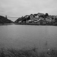
I recently indulged myself by buying a little piece of history. I've mentioned Samuel Loxton and featured and linked to his drawings before, often in the eminently browsable Loxton Collection albums that Bristol Libraries has on Flickr. So when I saw a Loxton drawing of Hotwells pop up on eBay, I decided to get myself a little treat.
I don't think there's any Loxton drawing that features the road I actually live in—it's not very visible from anywhere else, not being one of these Clifton terraces that's perched at the top of a hill, or anything like that, and it's invisible in most views of the area. However, this Loxton drawing, Hotwells, Looking across the river from near the Clifton Bridge station, is probably the closest near-miss I've seen.
I decided to wander out one morning and see if I could reproduce the picture, and also take a photo or two of what's now become of the Clifton Bridge Station, which is still just about discernible in places.
(Then on an even stranger whim I decided to check out a possible little cut-through from Cumberland Road to the harbourside I'd been eyeing up on my commute to work, so walked to Wapping Wharf for a croissant via this potential new route, but that bit's not quite as interesting...)
This must be some kind of invasive species. Normally the inhabitants of this island are the apprently-native shopping trolleys.
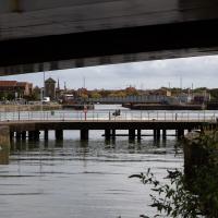
Every now and again some speedboat pops under Merchants Road Bridge and does a few quick loops of the Cumberland Basin. I guess that either they're allowed to go fast on the basin or they know they can get away with it...
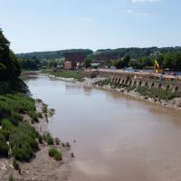
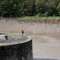
Site of the Rownham Ferry. Follow the link for a charming Loxton ink drawing on Know Your Place, also viewable at the Bristol Libraries Flickr collection.
This was a later site for the ferry, which earlier was a tad further out along the river. It would have been a key crossing point at this end of Bristol before the arrival of any bridges near here. Before the Ashton Swing Bridge and the Vauxhall footbridge arrived, the next-nearest crossing point would have been the Vauxhall ferry, which was where Vauxhaull Bridge stands now, I think.
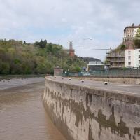
I think this was about my best attempt to match the Loxton angle. The fact that my photo still has the edge of Entrance Lock in it suggests that Loxton's drawing was taken from a little further downstream, but there are trees there now, obscuring the view.
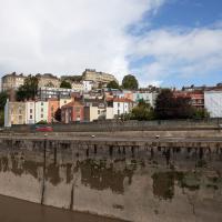
Much of the buildings further back are unchanged, as you can see, especially Windsor Terrace to the left and The Paragon middle top. The diagonal rise of Freeland Place is still there, too. What's mostly changed is the closer road, where a chunk of Hotwells, including the houses and Cumberland Hall you can see in the Loxton drawing, was swept away for the Cumberland Road flyover system. This probably also explains why there aren't so many pedestrians just enjoying the scenery—it's much noisier there now.
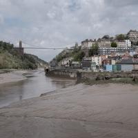
Here's a similar angle to my earlier attempt at recreating the Loxton view, only with a framing that gives a bit more detail of the buildings.
Well, they may have a point. This is Vauxhall Bridge, previously the site of Vauxhall Ferry. People seem to guess it must have had some connection with Bristol's Vauxhall Pleasure Gardens, but that seems unlikely to me, given that they were not long-lived and closed down before the New Cut was dug, so they woudln't have needed a ferry here...
Fresh Fields
17 Oct 2021
For the first time in a while, I had the time and energy to go further afield and knock off some new roads from my "to do" list. I headed through the first Hotwells Festival to Ashton and Bedminster to cross off a few of the suburban roads south of North Street.
First, though, I decided to try to reproduce an old photo of the now-demolished Rownham Hotel just around the corner from where I live...
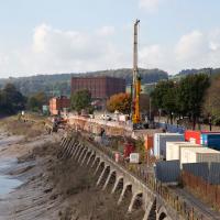
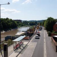
Apparently the repair of the Chocolate Path itself is now underway here. I won't hold my breath. Shame, as it's within my mile and one of my favourite walks and I've had no chance to walk down it since long before I started this little project.
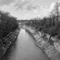
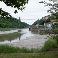
To give you an idea of what it's like down on the path, here's a photo from 2017 from behind where I'm standing on Vauxhaull Bridge here.