Tagged: river-avon
Ticking Off a Few Streets in Bedminster
31 Oct 2021
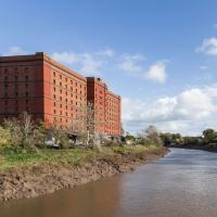
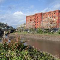
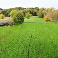
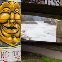
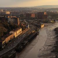
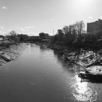
There were only a few streets left to wander in the more residential bit of Bedminster, so I thought I should target those today. The streets themselves weren't that notable, though Balfour Road has a contrasting mix of old and new housing. I tried to snap a few more interesting things along the way there and back, snapping all three of the familiar bond warehouses, nipping onto North Street to find some new street art, and finding a few pumpkins for good measure. It is hallowe'en, after all...
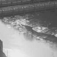
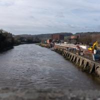
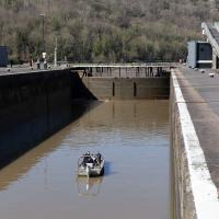
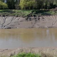
You can see the disturbance in the water on the river side as the sluices drain water from the lock to equalise the levels.
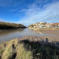
I went out simply wanting to knock off the very last little unwalked section of Clanage Road, over by Bower Ashton, which has been annoying me for a while as it's quite close by and I've walked the other bits of it several times. So, my plan was to nip over to Greville Smyth Park via a slightly unusual route to wander Clanage Road and tick it off.
Along the way, though, I inevitably got a bit distracted. I took a few photos of Stork House, a grand Hotwell Road building that's recently been done up a bit (I imagine it's student lets, though I'm not sure) and which I found a reference to in a book about the Port Railway and Pier the other week, and also tried to match up a historical photo of Hotwells before the Cumberland Basin Flyover System laid it waste, which included some interesting markers I'll have to do a bit more digging into...
Bower Ashton is an interesting little area just south of the river from me—in fact, the Rownham Ferry used to take people over from Hotwells to Bower Ashton, operating from at least the twelfth century to around the 1930s.
It's a strangely contradictory little area, with a cluster of old and new houses sandwiched in between the busy A-roads and significantly more industrial area of Ashton and the bucolic country estate of Ashton court roughly east to west, and also between Somerset and Bristol, north to south.
I've been around here before, mostly poking around Bower Ashton's arguably most well-known bit, the Arts faculty campus of the University of the West of England, but I'd missed at least Parklands Road and Blackmoors Lane, so I initially planned just to nip across briefly and wander down each in turn. On a whim, though, I texted my friends Sarah and Vik in case they were out and about, and ended up diverting to the Tobacco Factory Sunday market first, to grab a quick flat white with them, extending my journey a fair bit.
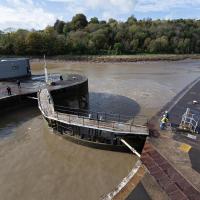
To start with, though, I nipped to a much more local destination, to see something that you can't actually see at all, the Gridiron...
(I also used this wander as a test of the cameras in my new phone. I finally upgraded after a few years, and the new one has extra, separate wide and telephoto lenses compared to the paltry single lens on my old phone. Gawd. I remember when speed-dial was the latest innovation in phones...)
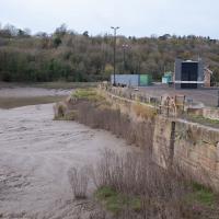
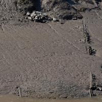
You can't actually see the Gridiron in this photo, but I believe it's still there, under that amazing buildup of silt.
The Gridiron—one of the few photos of it can be seen on the Maritime Mud and Miasma page of About Bristol—was a cheaper alternative to putting your boat in a dry dock. It was a 200-foot long grid (there seems to be some debate over whether the grid itself is actually metal, or in fact timber; I'll have to try to find out), 38 feet wide, nestled here between the north and south entrance locks. A ship captain could sail his vessel over here at high tide, then as the tide gradually receded, the ship—up to 250 feet, as overhanging a bit was apparently okay—would settle onto the gridiron.
At that point an inspection and repair crew could make their way down to the gridiron by ladder and do whatever work they could manage before the tide rose up again.
You can still see some ladders in place, I can only presume they were there to get you down to the gridiron, but that is just a guess; information on it seems quite hard to find.
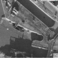
Image from 1946 Aerial layer of KYP Bristol/English Heritage.
As you can see, it was pretty big, and clearly still in use in 1946...
One last snap before we move on. I'm using the wide lens on the iPhone here, and have managed to include a silhouette selfie...
I decided to try out the three lenses on my new iPhone camera. This is the "telephoto" lens. It does a reasonably creditable job, though the phone is oversharpening things a bit and I'm not sure I like the colours much.
And here's the middling lens on the camera. Not bad, though on every shot I've taken on the iPhone so far where it's been able to see blue sky it's managed to oversaturate it for my tastes. Still, I guess they're aiming at the mass market, and the mass market does seem to like oversaturated colour and the sharpening turned up to eleven.
Not bad, and it's certainly better than not having a wide-angle lens in your pocket everywhere you go. I won't complain too much. "My iPhone oversaturates my photos. Also my wallet is too small for my fifties and my diamond shoes are pinching..."
A Constitutional to Burwalls and Back
21 Dec 2021
The recent lack of posts here is mostly due to my feeling very run down following having a couple of wisdom teeth extracted. Having had an emergency appointment yesterday1, hopefully I'll be on the mend now, though it does mean I'm on the kind of antibiotics where you can't touch alcohol for the whole of the Christmas period. I have tried to keep myself a little distracted from the pain by working on the nuts and bolts of this website—you should notice that the front page loads rather faster now than it used to, and that there's a shiny new statistics page that I'll probably be continuing to work on. Oh, and you should find that the tags below the photos are now clickable and will take you to a page of all other wanders that have photos with the same tag.
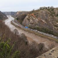
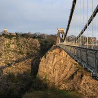
Today I felt like I needed to drag myself out of the house, but I didn't want to go too far, and I needed to get to the Post Office up in Clifton Village to post a Christmas card (spoiler for my parents: it's going to be late. Sorry.) As luck would have it, idly looking at the map I spotted that I'd missed off a section of Burwalls Road in the past, and that's basically one of the long-ways-round to Clifton Village, crossing the river to Rownham and walking up the hill on the Somerset side before coming back across the Suspension Bridge.
As I was heading for Burwalls Road I decided to make Burwalls itself the focal point of the walk, but unfortunately the mansion grounds are private and the place is hard to snap. Still, at least it gave me a destination. Burwalls was the mansion built by Bristol press magnate Joseph Leech, who I've mentioned before after buying a vintage book he wrote on a previous wander. There's a good article about the house on House and Heritage which has some photos from angles I couldn't ever get to. (Well, maybe with a drone, but it seems like the kind of area where they may be kitted out for clay pigeon shooting, so I probably wouldn't risk it.)
1 My dentist admitted that she probably needed to keep her internal monologue a bit more internal after we started the appointment with her staring into my mouth and immediately saying, "oh, *that's* weird." These are words one doesn't want to hear from a medical professional.
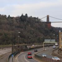
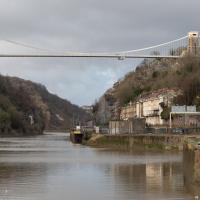
As my plan was to knock off the remaining section of Burwalls Road, my first photo is the small segment of Burwalls itself that you can see from near my house. Burwalls is the mansion on the hilltop, peeping out about halfway from the left edge of the photo and the Suspension Bridge.
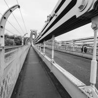
Most every time I cross the bridge, I remember one of the first times I walked over it, back in the late 1990s or early 2000s, when some wag—possibly even Banksy, who knows?—had painted a sign on the footway about here: a rectangle of yellow caution stripes containing the words "WARNING. CONCEALED TRAPDOORS IN OPERATION".
Technically that's still actually the Hotwell Road down there, and it doesn't become the Portway until the Bridge Valley Road junction, but I needed the alliteration, okay?
This is the kind of photograph that I really like, but is harder to find appreciation for these days—the Panavision aspect ratio I've chosen, 2.35:1, doesn't play nicely with today's standard media consumption device of a mobile phone held in portrait orientation. Maybe one day we'll all be using the internet through VR headsets and landscape orentation will make a comeback.
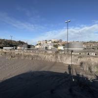
I was just about starting to feel better—the antibiotics seemed to have kicked in for my dental issues, and it had been some days since I'd left the house, and I was at last starting to get itchy feet. So, a wander. But where? Well, there were a few industrial bits near Winterstoke Road in the Ashton/Ashton Vale areas of Bristol that needed walking. I knew they were likely to be quite, well, unattractive, frankly. So why not do them while I wasn't feeling exactly 100% myself? Maybe it would fit my mood. Hopefully you're also in the mood for a bit of post-industrial wasteland, for that's what some of this feels like...
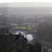
Then, at the last minute, I thought again about the Bristol International Exhibition—I've got a book about it on the way now—and that gave me another goal, which could just about be said to be in the same direction, and I decided to walk significantly further than my normal 1-mile limit and try recreating another historical photo...
Sadly I don't know much about the Ashton area; it's just on the edges of my mile and I rarely have cause to go there. It's brimming with history, I'm sure: the whole South Bristol area rapidly developed from farmland to coal mines to factories to its current interesting mixture of suburbs and industrial work over the last few hundred years. As a more working class area less attention was paid to it by historians, at least historically-speaking, than the Georgian heights of Clifton, and much of it has been knocked down and reinvented rather than listed and preserved. I see here and there some of this lack is being addressed, but I'm afraid I'll be very light on the history myself on this wander, as most of my usual sources aren't throwing up their normal reams of information as when I point them at Clifton, Hotwells or the old city.
I nearly didn't take this photo, having snapped this view so many times before, but I do find it almost completely irresistible.
I've often wondered about writing some kind of neural-computing based app that could look through all of my photos for snaps of this view and mash them all together into a time-lapse, or something, but that would be quite the project.
Near and Far
05 Jan 2022
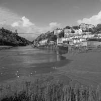
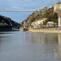
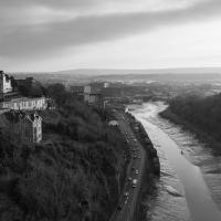
I took advantage of a rare recent day where it wasn't tipping down with rain to get away from my desk on a lunchtime workday and head up to Clifton Village. I'd hoped to snap a reproduction of historical photo which I'd worked out had been taken from the Suspension Bridge, but the gods were not smiling on me. Still, taking only a nice long lens with me worked out very well as the lovely haze of the day made more distant views quite dramatic...
This is almost the photo I wanted to take, but the historical photo I want to reproduce was definitely taken from further to my right, on the bridge, and you should still be able to see the remains of Clifton Bridge Station (hidden from here by the trees on the right) and the last bit of slipway of the Rownham Ferry (hidden by the prominent house in the foreground.) This snap is also a bit marred by the temporary safety fencing I had to shoot through.
Ah well, another day, I suppose.
Quick Clifton Jaunt Finishing with Southville
09 Jan 2022
It's been pretty dismal recently, weather-wise, so when Sarah called up to say that she and Vik had just left the swimming pool at the student union building up in Clifton, and would I like to join them for a trip to the Last Bookshop, also known as The £3 Bookshop, for reasons you can probably deduce, I leapt at the chance.
Not many photos on this walk, but I did manage to get down a little road I'd never been to before, basically just the access road to a car park at a block of flats, but it was on the map looking all tempting, so I figured I'd knock it off the list as we were passing.
Lunchtime Reproduction (of an old photo...)
17 Jan 2022
This was basically the quick lunchtime jaunt I tried to do at the beginning of January, only this time I actually managed to get to roughly the viewpoint I'd been hoping for to recreate a historical photo of the Bristol International Exhibition.
I did this walk about a month ago, but I've been a bit poorly and not really up to doing much in my spare time, and it's taken me this long to even face processing even these few photos. Hopefully normal service will be resumed at some point and I can carry on trying to walk any roads and paths that I need to do to make this project feel complete...
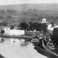
From Bristol's Lost City, by Clive Burlton, available from Bristol Books; photograph from the author's own collection.
(And extra credit goes to my parents for buying me the book for my birthday! Thanks!)
The Bristol International Exhibition site, presumably around 1914 or not long after. You can see the Rownham Ferry in use, too. I still find it pretty amazing that there used to be a busy ferry and a significant railway station on this little scrap of land that I just used to know as the grassy bit at the start of the towpath, let alone a replica of Bristol Castle!
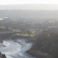
Unlike my last attempt I successfully managed to get somewhere near the vantage point of the historic photo this time...
I should probably have tried to get it at high tide to make it a bit more comparable, but you can't have everything.
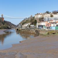
You can see the White City Allotments—those glints of light toward the middle are mostly reflections from greenhouses—where the "White City" of the Exhibition used to stand. There's still a glimpse or two of the railway line to Portishead to be seen, too, along with a vestige of the Rownham Ferry slipway.
Mostly though it's the modern things that stand out—the long line of flats along Paxton Drive, the curve of Brunel Way across the river, and the roof of Ashton Gate Stadium...
Leigh Woods Purple Path
12 Mar 2022
There's a few tracks in Leigh Woods that lie within my mile and show up on my map but that I've not walked yet, so I decided to take one of my traditional big long walks through the woods on this nice crisp sunny morning.
For years—decades, even—I've been doing a similar route from my place, along the towpath to the far woods entrance, up the hill for a varied walk on one of the marked tracks and then across the Suspension Bridge to Clifton Village for a coffee-based reward. It's my default "long walk", really, and I almost always enjoy it. Today, at last, spring actually seemed to be springing, which made for some extra positivity...
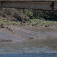
I mostly went out to hang out with my friends Sarah and Vik in Bedminster, but along the way I thought I'd take a closer look at something a little nearer home: the last crossing point of the Rownham Ferry.
That reminds me; I must re-read Iain M Banks's Use of Weapons again. In the novel he used the name Size Isn't Everything for one of the Culture's General System Vehicles, a spacecraft approximately 80km long... In the Culture, spacecraft are sentient and Culture ships choose their own names, often ironically.
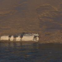
He we have something of the opposite size of craft.
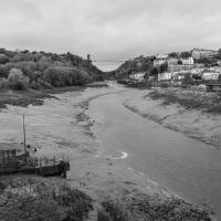
You don't often see Entrance Lock cycle at this kind of tide, but a little boat like that doesn't need a lot of water in the river to manoeuvre.
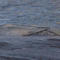
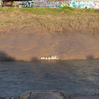
Yes, okay, it's quite the challenge to spot the hand-made historic artifact in this picture. In the next pic I'll zoom in a bit.
There, hopefully you can see it now—the slipway of the last incarnation of the Rownham Ferry, in use from as early as the 12th century to 1932, when this particular slipway was last used.
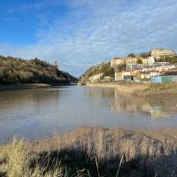
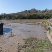
There's not much to see at the moment, as the tide's a bit too high. I'm going to head over to the Tobacco Factory Market, meet some friends, do a crossword or two, and head back at lower tide.
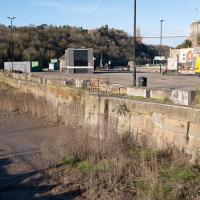
Again, the slipway is easy to miss. I like these little barely-visible curiosities that hide such heritage. The site of the crossing moved around—it's fairly obvious it wasn't right here in the 12th century, for example, because the river was only diverted into the New Cut, which the ferry crosses here, in the early 1800s. Earlier it was further downstream.
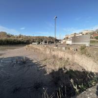
Now the tide's lower, we can see the end of the slipway we looked at earlier poking out from the Somerset side. According this article from the Bristol & Avon Family History Society:
In 1793 the ferry was identified as being used by many passengers to "cross the river at Rownham ferry and walk to the sweet and wholesome village of Ashton to eat strawberries and cream"
At an earlier site, the ferry was mentioned in the Proceedings in the Court of the Star Chamber in the Reigns of Henry VII and Henry VIII after a dispute between a new competitor and the existing ferry, which was run by St Augustine's Abbey. Presumably the crossing was used to get to and from the abbey property at Abbots Pool, which I've actually swum in, from the Abbey, now Bristol Cathedral.
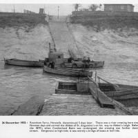
And here's the picture that inspired this little local visit today. A week or so back I was browsing the boxes of books at Rachel's and Michael's Antiques on Princess VIctoria Street, and flipping through their collection of Reece Winstone books. Winstone's famous Bristol As It Was series are an amazing documentary source created by a man who loved both photography and Bristol and effectively became Bristol's foremost documentary photographer for decades. A lot more of Bristol's history is visible today because of him.
In the Bristol As It Was 1939 - 1914 book I saw this picture of the Rownham Ferry. Unfortunately the book was a first edition and priced at £20, so I ordered a cheaper edition from an independent dealer in Stockport when I got home! (Let's consider that as me leaving the rare first edition for the true connoisseurs, rather than just being cheap.)
Here we see the ferry just five days before its closure on the last day of 1932. Looking closely, it seems to be perhaps operating as a reaction ferry, with the boat tethered to a static line across the river, and the ferryman using the rudder to turn the boat and use the power of the flowing water to shuttle the boat from side to side. Clever!
Photo © Reece Winstone Archive. (I recommend buying the books if you like old photos of Bristol. They're amazing!)