Tagged: of
Bedmo and Ashton Court
21 Nov 2020
A rather more wide-ranging weekend wander with Sarah and Vik, taking in some mock Tudor bits of Bedmo (I should note that I've subsequently been corrected to "Bemmie", but I'm an outsider and have been calling it "Bedmo" for short for decades...), a chunk of Ashton, a path up Rownham Hill called Dead Badger's Bottom(!), The Ashton Court estate, a bit of the UWE campus at Bower Ashton, and some of the Festival Way path.

Tags: Bristol Places UK onemilematt united kingdom Ashton
Auto-Tags: Hazard Triangle Font Wood Line Road surface Gas Landmark Road Signage Metal Sign Pattern Motor vehicle Symmetry
Text Recognition Tags: DANGER OF DEATH KEEP OUT WESTERN POWER DISTRIBUTION IN EMERGENCY TEL: 0800 365900 DANGER OF DEATH KEEP OUT WESTERN POWER DISTRIBUTION IN EMERGENCY TEL: 0800 365900
Tags: Bristol Places UK onemilematt united kingdom Ashton
Auto-Tags: Plant Nature Botany Vegetation Font Grass Brick Rectangle Brickwork Groundcover Petal Grass family Landscape Commemorative plaque Signage
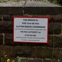
Text Recognition Tags: THIS BRIDGE IS: POD 121m 68.75ch CLIFTON BRIDGE OVERBRIDGE In the event of any raad vehicles striking this bridge piease cortact THE RAIL AUTHORITY on 01793 533 592 as quickly as possible. The salety of trains may be affected. This bridge is owned by Network Ral THIS BRIDGE IS: POD 121m 68.75ch CLIFTON BRIDGE OVERBRIDGE In the event of any raad vehicles striking this bridge piease cortact THE RAIL AUTHORITY on 01793 533 592 as quickly as possible. The salety of trains may be affected. This bridge is owned by Network Ral
Tags: Ashton Court Estate Bristol Places UK onemilematt united kingdom Rownham Hill*. Ashton Court
Auto-Tags: Fence Wood Split-rail fence Land lot Grass Home fencing Grassland Landscape Grass family Meadow Road Lawn Outdoor structure Field Pasture
Text Recognition Tags: BEWARE OF TRAINS BEWARE OF TRAINS
Up for the flu jab
21 Nov 2020
A trip up the hill to get my winter flu jab. I'm not sure I really needed it this year, what with avoiding Covid—I haven't had so much as a sniffle in more than a year—but seeing as they offered... Instead of the doctor's surgery on Pembroke Road, they'd taken over Christ Church, presumably to give more room and ventilation for the necessary social distancing at the moment. As usual, it was their typically efficient operation, and I was in and out in about three minutes.
On the way there and back I snapped as much as I could, but I wanted to be home in time for the first online Times Crossword Championship. As it turned out, I needn't have bothered, as the technology at the Times couldn't keep up with the demand from competitors, and their system just collapsed under the weight of page-views. They tried again the day after, and it collapsed just as badly. Maybe next year...
This wander is split into two parts, as I turned my tech off to go into Christ Church for my jab. The walk home can be found over here.
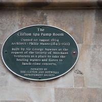
Tags: Bristol Places UK onemilematt united kingdom Clifton Village omm plaque Clifton Spa Pump Room
Auto-Tags: Font Circle Symmetry Commemorative plaque Public utility History Concrete Interior design Memorial Composite material Slate
Text Recognition Tags: The Clifton Spa Pump Room Opened Ist August 1894 Architect - Philip Munro (1843-1911) Built by Sir George Newnes at the request of the Society of Merchant Venturers as a place to take the healing waters and listen to lunch-time concerts. DONATED BY THE CLIFTON AND HOTWELLS IMPROVEMENT SOCIETY The Clifton Spa Pump Room Opened Ist August 1894 Architect - Philip Munro (1843-1911) Built by Sir George Newnes at the request of the Society of Merchant Venturers as a place to take the healing waters and listen to lunch-time concerts. DONATED BY THE CLIFTON AND HOTWELLS IMPROVEMENT SOCIETY
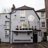
Tags: Bristol Places UK onemilematt united kingdom Clifton Village omm Portland Street Cori tap Coronation Tap pub
Auto-Tags: Sky Window Building Plant Tire Wheel Car Infrastructure Door Vehicle House Vehicle registration plate Road Facade City
Text Recognition Tags: The Cori Tap PARI HELES The home of Eaon cider The Cori Tap PARI HELES The home of Eaon cider
Avoiding the Accounts
26 Nov 2020
I took the day off my day job to do my accounts—or at least do enough bookkeeping to send them to my accountant. I hate doing the books. I woke up late, tired and with a headache and decided to bunk off for a walk around Cliftonwood, Clifton Village and Clifton instead, taking in a couple of good coffees along the way. Thanks, Foliage Café, and Twelve for the flat whites.

I love a cafe sign. Foliage Cafe, Regent Street, Clifton
Tags: Bristol Places UK onemilematt united kingdom Clifton Village Foliage Cafe cafesigns
Auto-Tags: Drinkware Automotive tire Wood Drink Handwriting Serveware Font City Tableware Metal Cup Dishware Cup Automotive design Fashion accessory
Text Recognition Tags: SOUP OF THE DAY MASK 50 SMOKY BUIERNUTSUPS SOUP OF THE DAY MASK 50 SMOKY BUIERNUTSUPS
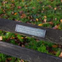
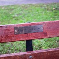
I'd like someone to dedicate me a bench once I'm dead
Tags: Bristol Places UK onemilematt united kingdom
Auto-Tags: Wood Grass Plant Groundcover Font Bumper Natural material Rectangle Metal Soil Guard rail Landscape Sign Herb Outdoor bench
Text Recognition Tags: la continuing memory of De MAVIS E COOKE (formerly COUTTS) 24th January 1926-23rd Jene 19RI la continuing memory of De MAVIS E COOKE (formerly COUTTS) 24th January 1926-23rd Jene 19RI
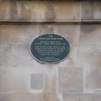
Another place that wasn't there in Fanny Burney's time—Evelina visits the Hot Well and Pump Rooms, but this would have been the original building down on the bank of the Avon below, long before the upper pump room or the funicular railway from here, next to the Avon Gorge hotel, that linked to the Portway below, existed.
In the novel Evelina in fact stayed in Hotwells, from what I can work out, rather than Clifton, as getting from Clifton to the Hot Well itself every day would have been too much travelling at the time.
Tags: Bristol Places UK onemilematt united kingdom
Auto-Tags: Font Wood Commemorative plaque Concrete Facade Symmetry History Number Public utility Limestone Memorial Rectangle Pattern Circle Signage
Text Recognition Tags: The clifton Spa Pump Room Opened ist Aoget 1894 Architect - Phitlo Munro (B43-101) Suitt by Sir Grorge NawnE at the request of the society of Merchant Venterers as a place to take the hesling waters and iisten to lanch-time concerts DUNATED EY THE CLITON AMD HOTVELLA The clifton Spa Pump Room Opened ist Aoget 1894 Architect - Phitlo Munro (B43-101) Suitt by Sir Grorge NawnE at the request of the society of Merchant Venterers as a place to take the hesling waters and iisten to lanch-time concerts DUNATED EY THE CLITON AMD HOTVELLA
The Long Lunchtime at the End of the World
27 Nov 2020
I took an extra-long break at lunchtime today as I'd taken the day off my normal day-job to do the accounts for my previous side-job, which is still generating paperwork, though not much in the way of money. This took me through some undiscovered bits of Cliftonwood, including Worlds End Lane, which unexpectedly leads to White Hart Steps. That's certainly not where I expected the end of the world to lead to...

Sobering. A couple of years younger than me, from what I can find on the web he died when his motorcycle was in collision with a car at the nearby corner with Dean Lane.
Tags: Bristol Places UK onemilematt united kingdom Coronation Road
Auto-Tags: Natural environment Wood Motor vehicle Plant Biome Grass Font Natural landscape Twig Signage Groundcover Landscape Forest Metal Tree
Text Recognition Tags: In Loving Rememberence of The life of Billy James Sunrise London 09.09.1963 Sunset Bristol 10.10.2008 Always on our minds. Always in our hearts Always to be remembered, With a smile & a tear. in Gods Keeping. In Loving Rememberence of The life of Billy James Sunrise London 09.09.1963 Sunset Bristol 10.10.2008 Always on our minds. Always in our hearts Always to be remembered, With a smile & a tear. in Gods Keeping.
A long ramble, starting with trying to find the Hot Well of Hotwells and leading up the side of the Avon Gorge to the Downs and then through Clifton for coffee.
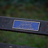
Thirty. Goodness.
Tags: Bristol Places UK onemilematt united kingdom Avon Gorge Lydia Koshiw
Auto-Tags: Wood Grass Font Motor vehicle Groundcover Electric blue Metal Signage Sign Landscape Logo Symbol Number Rectangle Steel
Text Recognition Tags: In loving memory of Lydia Koshiw 8.2.1985 - 11.11.2015 "Siư down, you're rocking the boat. In loving memory of Lydia Koshiw 8.2.1985 - 11.11.2015 "Siư down, you're rocking the boat.
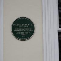
Tags: Bristol Places UK onemilematt united kingdom Clifton Village plaque Clifton Eugenie de Montijo Napoleon
Auto-Tags: Font Wood Rectangle Circle Event Signage Fixture Room Commemorative plaque Brand History Memorial
Text Recognition Tags: Clifton nd Horwells EUGÉNIE DE MONTIJO (1826 - 1920) WIFE OF NAPOLEON III EMPRESS OF THE FRENCH ATTENDED SCHOOL HERE 1836 Imgrovement. Seciery Clifton nd Horwells EUGÉNIE DE MONTIJO (1826 - 1920) WIFE OF NAPOLEON III EMPRESS OF THE FRENCH ATTENDED SCHOOL HERE 1836 Imgrovement. Seciery
Ten O'Clock Shop and Can't Dance Coffee
30 Nov 2020
I had to return a faulty AirPod Pro to Apple (there's a first-world problem!) so I just took a quick trip up the hill to the nearest UPS drop-off point, The Ten O'Clock Shop, which is famously open until 11pm. Unfortunately it's a fairly cramped little place and neither of the staff were wearing masks, so I made it a very quick drop indeed and got out of there as quickly as I could.
I grabbed a quick coffee from Can't Dance, a stall that's—as of yesterday—in a tiny converted cargo container on the edge of Victoria Square; up until this week they were running from a little trike parked in the same place. Hopefully the new premises will let them see out the winter without worrying quite so much about the weather.
I tried to fit in a few extra streets from the surrounding area on my there and back, but that was basically my wander today: a quick little shopping trip.
A plaque to Charlotte and Zaani Bevan. Heartbreaking.
Tags: Bristol Places UK onemilematt united kingdom Clifton Village Charlotte Zaani
Auto-Tags: Leaf Wood Motor vehicle Rectangle Bumper Grass Brick Automotive exterior Groundcover Font Landscape Table Natural material Wood stain Plant
Text Recognition Tags: alone Menmors Of Cherloiie and Zaani alone Menmors Of Cherloiie and Zaani
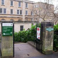
Tags: Bristol Places UK onemilematt united kingdom Clifton Village
Auto-Tags: Plant Building Property Vehicle registration plate Window Vehicle Car Motor vehicle Architecture Tree Neighbourhood Residential area Road surface Automotive exterior Real estate
Text Recognition Tags: MANDA HALLO University of Bristol property MANOR HALL No public right of wny BRISTOL www MANDA HALLO University of Bristol property MANOR HALL No public right of wny BRISTOL www
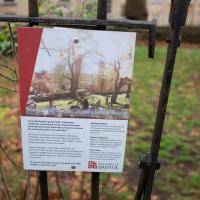
Tags: Bristol Places UK onemilematt united kingdom Clifton Village
Auto-Tags: Plant Plant community Vertebrate Leaf Branch Wood Natural landscape Mammal Grass Land lot Biome Font Woody plant Twig Fence
Text Recognition Tags: Manocmer Gardensisnowa Buzzing Hotspotf ade nd University of BRISTOL Manocmer Gardensisnowa Buzzing Hotspotf ade nd University of BRISTOL
Nothing New
02 Dec 2020
This may be the very first time I've gone for a One Mile Matt wander and not actually gone down any new roads, trod any new steps. I just wanted a coffee, frankly, so I went the same old way to Imagine That in the marina and back again.

This is the current plan to replace the caravan park
Tags: Bristol Places UK onemilematt united kingdom baltic wharf
Auto-Tags: Property Light World Architecture Font Line Sky Material property Natural landscape Publication Real estate Adaptation Landmark Landscape Travel
Text Recognition Tags: BALTIC WHARFI NEW HOMES FOR BALTIC WHARF Hew the propesed deveinpmemt cend oek frem the Flating Harter WHAT IS PROPOSEO FOR BALTIC WHARF? WHY DO WE NEED MORE NEW HOMES? Goram Homes, Bristol City Council's housing company, has partnered with Hil to propose transformational plans for Baltic Whart This would provide approsimately 165 new homes, including 406 affordable. It is widety acknowledged that the curent housing crisis has led to the under provision of housing and particularly atfordable housing within Bristol. Although much is being done in the City to address the crisis, there are key issues with affordability, rough sleeping, and lack of social housing Bristol currently has over 13,000 famlies on the affordable housing register and a further 710 people in temporary accommodation. The aim is to create a vibrant destination on the Floating Harbour with homes, retail, restaurants and commercial spece, one that is well connected to local walking and cycling routes, seamiessly integrates with the historic setting and capitalises on the waterfrort setting with expansive views across the lamous Bristol townscape. Comparing house prices in Bristol to those in other Core Cities in the decade between 2008 and 2018 indicated that Bristol had the highest average housing costs of all the Core Cities in this period, and also the highest percentage Increase - over S6, compared to a UK average increase in costs of just over 32 The site is the Boltik Wharf Carian Club, The site is owned by Bristol City Counci and as part of the overarching ambition to deliver high quality homes, this site has been identified as a site capable of providing bomes for Bristal. GORAM HOMES 出Hill Goram Homes was founded in 2018 as part ol an initiative from Bristol City Counci, wich the ambition to increase the provision of nea hemes in the city and to meet affordable housing requirements without compromising on build quality Goram Homes is a subsidary of Bristol Holding Ltd, HIl is an award-winning 5 star housebuilder, creating a range of beautiful and awardwinning new homes across the south of England. They are a leading partnership developer, delivering distinctive and award-winning new homes, having been named Housebuilder of the Year, medium and large, in 2018. which is wholly owned by Bristol City Council Goram is set up to deliver mised tenure housing on a joint ventune basis and our share of profit wil feed back into the funding of council servicel BALTIC WHARFI NEW HOMES FOR BALTIC WHARF Hew the propesed deveinpmemt cend oek frem the Flating Harter WHAT IS PROPOSEO FOR BALTIC WHARF? WHY DO WE NEED MORE NEW HOMES? Goram Homes, Bristol City Council's housing company, has partnered with Hil to propose transformational plans for Baltic Whart This would provide approsimately 165 new homes, including 406 affordable. It is widety acknowledged that the curent housing crisis has led to the under provision of housing and particularly atfordable housing within Bristol. Although much is being done in the City to address the crisis, there are key issues with affordability, rough sleeping, and lack of social housing Bristol currently has over 13,000 famlies on the affordable housing register and a further 710 people in temporary accommodation. The aim is to create a vibrant destination on the Floating Harbour with homes, retail, restaurants and commercial spece, one that is well connected to local walking and cycling routes, seamiessly integrates with the historic setting and capitalises on the waterfrort setting with expansive views across the lamous Bristol townscape. Comparing house prices in Bristol to those in other Core Cities in the decade between 2008 and 2018 indicated that Bristol had the highest average housing costs of all the Core Cities in this period, and also the highest percentage Increase - over S6, compared to a UK average increase in costs of just over 32 The site is the Boltik Wharf Carian Club, The site is owned by Bristol City Counci and as part of the overarching ambition to deliver high quality homes, this site has been identified as a site capable of providing bomes for Bristal. GORAM HOMES 出 Hill Goram Homes was founded in 2018 as part ol an initiative from Bristol City Counci, wich the ambition to increase the provision of nea hemes in the city and to meet affordable housing requirements without compromising on build quality Goram Homes is a subsidary of Bristol Holding Ltd, HIl is an award-winning 5 star housebuilder, creating a range of beautiful and awardwinning new homes across the south of England. They are a leading partnership developer, delivering distinctive and award-winning new homes, having been named Housebuilder of the Year, medium and large, in 2018. which is wholly owned by Bristol City Council Goram is set up to deliver mised tenure housing on a joint ventune basis and our share of profit wil feed back into the funding of council servicel
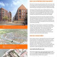
This is the current plan to replace the caravan park
Tags: Bristol Places UK onemilematt united kingdom baltic wharf
Auto-Tags: Property Architecture Font Line Urban design Real estate Landmark Screenshot Publication Facade Cloud Landscape Advertising City History
Text Recognition Tags: BALTIC WHARF WHAT ELSE IS PROPOSED OTHER THAN HOMES? Our aim is to create new public spaces, with a mix of uses, that encourage a sense of community and social inclusiveness, that are accessible to all, and which prioritise walking and cycling. social interaction and physical activity for a high quality of ife. The design of these public spaces wil draw heavily on the site's historical contet and harbournide setting, producing a unique space that acknowledges the area's history as a busy and dynamic working dockyard. This will be achieved with materials and public art that reference the site's heritage. The proposals will make the most of the waterfront location with seating steps and social spaces with striking views across the water for residents and locats. in contrast, private and semi-private amenity spaces on terraces and roof gardens will be calm and relasing with comfortable furniture and colourful and biodiverse planting. Ground floor commercial space is proposed on the harbour frontage, which could include a mix of places to eat and drink, in turn enhancing activity in this comer of the harbour and creating a new destination. The commercial space will complement rather than detract from The Cottage Inn and Underlall Yard, and could incorporate some local social enterprises, which will enhance footfal and promote social activity to further eniven the harbour setting Above: How theo cite cou lockhom Cumberlard Hoad HOW CAN I FIND OUT MORE? Goram Homes is keen to understand the views of local people and would like to encourage people to have their say. Given COMD restrictions, we have launched a dedicated website for the project, which provides more detail about what is proposed, whilst addressing some ef your questions and potential concems. The website also provides an opportunity to have your say on our plans before they are finalised and submitted in a planning application to Bristol City Councit Abover The proposals withintheir contot Belaw: The emergng site layout www.balticwharfhomes.com We have also organised an ontine presentabion for the wider community at Tpm on Thursday Bth October 2020 1o find out more, ask questions and give us their thoughts, Ifyou would like to attend, please visit this link to sign-up: www.balticwharfhomes.com/presentation If you are unable to visit either website, please give our Co Isultation team a call on 07342 039 444 (during office hours), who can book you in and make olternative amangements to get involved in the session, or provide all information in an alternative fomat appropriate for you BALTIC WHARF WHAT ELSE IS PROPOSED OTHER THAN HOMES? Our aim is to create new public spaces, with a mix of uses, that encourage a sense of community and social inclusiveness, that are accessible to all, and which prioritise walking and cycling. social interaction and physical activity for a high quality of ife. The design of these public spaces wil draw heavily on the site's historical contet and harbournide setting, producing a unique space that acknowledges the area's history as a busy and dynamic working dockyard. This will be achieved with materials and public art that reference the site's heritage. The proposals will make the most of the waterfront location with seating steps and social spaces with striking views across the water for residents and locats. in contrast, private and semi-private amenity spaces on terraces and roof gardens will be calm and relasing with comfortable furniture and colourful and biodiverse planting. Ground floor commercial space is proposed on the harbour frontage, which could include a mix of places to eat and drink, in turn enhancing activity in this comer of the harbour and creating a new destination. The commercial space will complement rather than detract from The Cottage Inn and Underlall Yard, and could incorporate some local social enterprises, which will enhance footfal and promote social activity to further eniven the harbour setting Above: How theo cite cou lockhom Cumberlard Hoad HOW CAN I FIND OUT MORE? Goram Homes is keen to understand the views of local people and would like to encourage people to have their say. Given COMD restrictions, we have launched a dedicated website for the project, which provides more detail about what is proposed, whilst addressing some ef your questions and potential concems. The website also provides an opportunity to have your say on our plans before they are finalised and submitted in a planning application to Bristol City Councit Abover The proposals withintheir contot Belaw: The emergng site layout www.balticwharfhomes.com We have also organised an ontine presentabion for the wider community at Tpm on Thursday Bth October 2020 1o find out more, ask questions and give us their thoughts, Ifyou would like to attend, please visit this link to sign-up: www.balticwharfhomes.com/presentation If you are unable to visit either website, please give our Co Isultation team a call on 07342 039 444 (during office hours), who can book you in and make olternative amangements to get involved in the session, or provide all information in an alternative fomat appropriate for you
Strangers' Burial Ground
04 Dec 2020
I tried to find the Strangers' Burial Ground the last time was up in Clifton, but I'd not realised that Lower Clifton Hill continues further on after the turning with Constitution Hill. Sadly it was chained shut, but it still looks beautifully-maintained, perhaps by the same man referenced by this story from John Hodgson, which helped me find it. Apparently Thomas Beddoes is buried here.
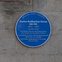
Now that's some serious achievement:
Dame Katharine Furse, GBE, RRC (née Symonds; 23 November 1875 – 25 November 1952) was a British nursing and military administrator. She led the British Red Cross Voluntary Aid Detachment force during the First World War, and served as the inaugural Director of the Women's Royal Naval Service (1917–19). Furse was also the first Director of the World Association of Girl Guides and Girl Scouts (1928–38).
Tags: Bristol Places UK onemilematt united kingdom Clifton Village plaque Clifton
Auto-Tags: Font Commemorative plaque Circle Electric blue Public utility Concrete History Road surface Memorial Number Art Signage Gas Cement Handwriting
Text Recognition Tags: CIVIC SOCIETY BRISTOL Dame Katharine Furse GBE RRC 1875 – 1952 was born here First Director, Women's Royal Naval Service and Founder, The Association of Wrens Commandant-in-Chief, Voluntary Aid Detachment (Bntish Red Cross Society) First Director, World Bureau of Girl Guides and Girl Scouts CIVIC SOCIETY BRISTOL Dame Katharine Furse GBE RRC 1875 – 1952 was born here First Director, Women's Royal Naval Service and Founder, The Association of Wrens Commandant-in-Chief, Voluntary Aid Detachment (Bntish Red Cross Society) First Director, World Bureau of Girl Guides and Girl Scouts
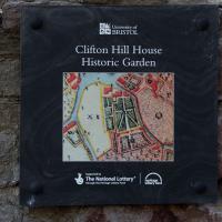
Maybe if we get through the pandemic and its lockdowns I'll be able to book a tour.
Tags: Bristol Places UK onemilematt united kingdom Clifton Village Clifton cliftonwood
Auto-Tags: Wood Rectangle Font Gadget Pattern Signage Geology Rock Public utility Soil Concrete Brick Metal Number History
Text Recognition Tags: Univenity of BRISTOL Clifton Hill House Historic Garden Sperted y The National Lottery e age Leyd tettage ryhund Univenity of BRISTOL Clifton Hill House Historic Garden Sperted y The National Lottery e age Leyd tettage ryhund
Alma Vale
06 Dec 2020
I wasn't really feeling it when I set out today, on my first car-assisted wander. By the time I'd parked on Alma Vale Road in Clifton it was just starting to rain and I picked my way about in quite a desultory way. It felt strange, as I was very familiar with the area because I'd walked through it hundreds of times when I worked at the top of Whiteladies Road, and used to walk up the hill from Hotwells and through Clifton to get there, and back again, every day.
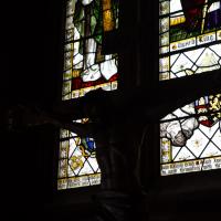
Then a complete coincidence seemed to make the change I'd been hoping for. I was standing taking a photo of Christ in the front garden of All Saints church when a couple of people walked out of the front door. I got talking with a lady I took to be part of the ministerial team, who invited me to come in and look around—something I'd always wanted to do on the morning commute. (I think we connected a bit when I recognised the name John Piper, who did the amazing windows—I learned about him while I was at Warwick, through his connections to Coventry Cathedral.
I left with much more of a spring in my step, wandered around the area a bit more, finally working out that the tennis courts I used to pass every morning are those of Clifton Lawn Tennis Club, and finally grabbing an excellent Hungarian sausage hot dog from the Budapest Cafe. I feel a lot better now than I did before I went out.
Tags: Bristol Places UK onemilematt united kingdom Clifton
Auto-Tags: Window Fixture Building Tints and shades Symmetry Stained glass Glass Art Building material Metal Daylighting Darkness Holy places Visual arts Pattern
Text Recognition Tags: SwArd king Bishop t rusrlurs wih tr surial ptrposr of SwArd king Bishop t rusrlurs wih tr surial ptrposr of
Rainy Clifton
13 Dec 2020
A long walk around Cliftonwood and Clifton with my friend Lisa, taking in some of the 12 Days of Christmas display at Queens Parade, picking up a take-away coffee from Pinkmans of Park Street, and poking our heads up against the glass of SS Peter and Paul Catholic Cathedral.
Tags: Bristol Places UK onemilematt united kingdom Queen's Parade Twelve Days of Christmas
Auto-Tags: Window Plant Building Fixture Road surface Wood Rectangle Brick Wall Brickwork Urban design Flooring Facade Asphalt Composite material
Text Recognition Tags: 出曲 fVELVE DAYS OF CHRISTMAS 出 曲 fVELVE DAYS OF CHRISTMAS
Tags: Bristol Places UK onemilematt united kingdom
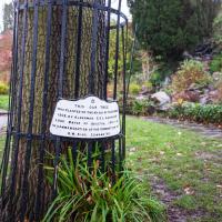
Auto-Tags: Plant Tree Natural landscape Wood Land lot Trunk Landscape Terrestrial plant Grass Groundcover Shrub Grass family Twig Lawn Font
Text Recognition Tags: NCOMMEMORATION OF THr to Lo Waree or eisT I THIS DAM TAEE MAS PLANTE oN THE a 1302. Y ALDcENA CEL CANi M.M. KING tawA VI NCOMMEMORATION OF THr to Lo Waree or eisT I THIS DAM TAEE MAS PLANTE oN THE a 1302. Y ALDcENA CEL CANi M.M. KING tawA VI
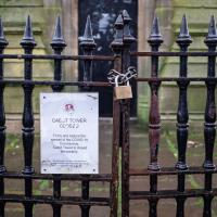
One day I'll get back up there.
Tags: Bristol Places UK onemilematt united kingdom
Auto-Tags: Fence Wood Line Home fencing Font Gas Metal Building material Composite material Gate Symmetry Guard rail Pattern Handrail Steel
Text Recognition Tags: CAE T TOWER CLISEJ To try and reduce the spread of the COVIO-19 Coronavi Catol Tuwer s closed amporarty CAE T TOWER CLISEJ To try and reduce the spread of the COVIO-19 Coronavi Catol Tuwer s closed amporarty
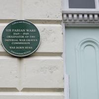
Tags: Bristol Places UK onemilematt united kingdom plaque Sir Fabian Ware
Auto-Tags: Azure Font Fixture Facade Wood Symmetry Rectangle Commemorative plaque Signage Circle Number Room Electric blue Siding Sign
Text Recognition Tags: Cifton and Hotwells SIR FABIAN WARE 1869 - 1949 ORIGINATOR OF THE IMPERIAL WAR GRAVES COMMISSION WAS BORN HERE Provement Soce Cifton and Hotwells SIR FABIAN WARE 1869 - 1949 ORIGINATOR OF THE IMPERIAL WAR GRAVES COMMISSION WAS BORN HERE Provement Soce
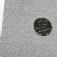
Tags: Bristol Places UK onemilematt united kingdom plaque C Lloyd Morgan
Auto-Tags: Grey Font Sky Tree Circle Concrete Commemorative plaque Public utility Artifact Twig Memorial History Rock Metal Rectangle
Text Recognition Tags: ovemet Secitty CHrisn and o e C.LLOYD MORGAN (1852-1936) PSYCHOLOGIST FIRST VICE-CHANCELLOR UNIVERSITY OF BRISTOL LIVED HEPRE 1886-1903 ovemet Secitty CHrisn and o e C.LLOYD MORGAN (1852-1936) PSYCHOLOGIST FIRST VICE-CHANCELLOR UNIVERSITY OF BRISTOL LIVED HEPRE 1886-1903