Tagged: on
Bedminster, Ashton, Ashton Court sunset walk
12 Dec 2020
A walk with Sarah focusing on Ashton and the surrounds, taken on a day with really nice light around sunset. Just what I needed.
Rainy Clifton
13 Dec 2020
A long walk around Cliftonwood and Clifton with my friend Lisa, taking in some of the 12 Days of Christmas display at Queens Parade, picking up a take-away coffee from Pinkmans of Park Street, and poking our heads up against the glass of SS Peter and Paul Catholic Cathedral.
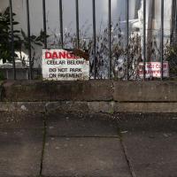
Gardens and Cottages
17 Dec 2020
I think the cute little Duncan Cottage was my favourite bit of this wander up the hill to get coffee and a pain-au-raisin from Twelve, though I did enjoy gently musing on the public and private gardens of Clifton, inspired by a closer pass than usual to Royal York Crescent's garden.
I managed absent-mindedly to clear my GPS track before saving it, so this hand-created track-log may cause me problems in the future. I suppose we'll see.
I went to have a peep at the giant sinkhole that's opened up in Canynge Square—ironically, having recently discovered the gardens were public I'd had the (triangular!) square on my list to re-visit for a few days, but now there's no entrance to the gardens due to the danger. The area was well fenced-off for safety, but I tried to get a couple of photos from behind the barriers.
I also explored the area around Camp Road, an real melange of architectures, one of the most mixed-up areas I've seen in Clifton, in fact, and confirmed my friend Claire's suspicion that an earlier snap of a sign from Manilla Road was in fact for a fire hydrant. Nice.
Saint Vincent's Spring
28 Dec 2020
Fractionally outside my one-mile zone, but I got curious about Saint Vincent's spring, whose last remnants you can see in a defunct drinking fountain on the Portway. Along the way I passed Gyston's cave, sometimes called St Vincent's cave, in the sheer wall of the gorge. It's now accessible by a tunnel from the observatory—I tried it about twenty years ago, I think, and still recall the vertiginous moment of looking down from the protruding balcony and realising that you could see straight through the grille floor to the drop below—but from what I can work out the tunnel is relatively recent. Before the tunnel was dug it was accessible only by access across the cliff face, which must have been even more terrifying.
This cave was first mentioned as being a chapel in the year AD 305 and excavations, in which Romano-British pottery has been found, have revealed that it has been both a holy place and a place of refuge at various times in its history.
A few different sources say that the cave became a hermitage and chapel to St Vincent following Bristol's early trading in Iberian wines; St Vincent of Saragossa is Lisbon's patron saint, and a lot of nearby things bear the name.
I'm not sure where the crossover of Vincent and Ghyston happens, though. On the giants Goram and Vincent (or Ghyston), Wikipedia says:
The name Vincent for one of the giants rests on the fact that at Clifton, at the narrowest point of the Avon Gorge, there was formerly an ancient hermitage and chapel dedicated to St Vincent, at or near the present cave in the cliff-face which bears his name. Another (apparently modern) version of the story calls the Clifton giant Ghyston, which is in fact the name, of obscure origin, for the whole of the cliff-face of the Avon Gorge at least as early as the mid-fifteenth century, in the detailed description of the Bristol area by William Worcestre. The place-name was personified to produce the giant's name. Vincent's Cave is called Ghyston cave or The Giant’s Hole in an article in the July 1837 issue of Felix Farley’s Bristol Journal.
In my research on the original Hot Well House, I've seen quite a few contemporary paintings which state their viewpoint as "from St. Vincent's Rock", so in the 16th century it seems the cliff-face name was typically St Vincent Rock rather than Ghyston's Rock, perhaps.
I am, as you can tell, no historian!
On the way, I also wandered around the base of the popular climbing area, which I think is the site of the old Black Rock quarry.
My historical research took a wander underground recently, partly inspired by the Canynge Square sinkhole, partly by St Vincent's (Ghyston's) cave and its tunnel to the Observatory, and I was surprised to find that there might be an intact tunnel from the Bristol Port Railway and Pier still just sitting there under Bridge Valley Road. A quick search turned up this recent video by an intrepid explorer, so it's definitely still there.
I went looking for the entrances today, and definitely found the south entrance, at the start of the Bridge Valley Path, the footpath that starts with steps at the bottom of Bridge Valley Road. It's easy to miss if you're not looking for it. I think I've figured out where the north entrance is, too, but it was getting dark at that stage and the Portway was still busy enough that crossing the road was still the normal nuisance, so I thought I'd leave further explorations for another day.
- Nice. It's just on the other side of the Promenade from the Alderman Proctor's Drinking Fountain.
Mirror Maze
10 Jan 2021
Went for a wander with my friend Lisa—the current lockdown rules seem to be that one local walk for exercise per day with a maximum of one person not in one's "bubble" is fine—up to the University of Bristol area right at the edge of my one-mile perimeter to see the Jeppe Hein Mirror Maze, among other things. On the way we mused about Merchant Venturers, the slave and tobacco trades, and dating in the time of Covid.
Birthday Coffee
21 Jan 2021
A quick jaunt to Clifton Village to grab a birthday coffee and cake (courgette, lime & pistachio, thanks for asking) from Twelve, and rubberneck at the demolition of the block that used to house the WH Smith, among other things. I remember the Havana Cafe, Mail Boxes Etc (for those who wanted a Clifton postcode without living there?) and others.
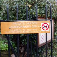
I wonder if the bit about it being closed for one day a year is a non-sequitur, or whether there's actually some legal requirement to close the garden every now and again to maintain its private status.
Another Lunchtime, Another Quick Coffee Trip
28 Jan 2021
With very little photography, and no new streets. Still, I did manage to buy milk at the "Simple Cow" vending machine—and "simple" is very definitely false advertising; it took me bloody ages to work out how to use the thing—and snap the new ACER/SEPR piece down in Cumberland Piazza.
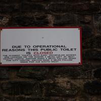
Jacob's Well Wander
01 Feb 2021
I just wanted to get some exercise, really, so I set out to knock off the lower bit of Jacobs Wells Road that I'd not managed to walk up yet. I set the new signboard that the community association had had erected as my destination, after reading about it on their blog.
As it turned out, I couldn't even read it, as the building that houses the actual Jacob's Well had water flooding out onto the pavement. I wonder if it was actual Jacob's Well water? Have the soles of my walking shoes been mystically blessed now?
You can't see much of the flood in the photos I snapped, but I did shoot a little video, too. Ed on Twitter said:
I spoke to the seller at the time with a view to buying it - I mentioned an old friend who grew up nearby remembers it flooding regularly. He swore blind my friend was wrong.
Laundry room? I took a guess at that and googled it and apparently there is "a useful communal laundry room", so it seems likely.