Tagged: on
Bedminster Trip for New Walking Shoes
26 Feb 2022
I needed to buy new walking shoes—my old ones were squeaking and it was driving me up the wall—so I ordered some for collection from Taunton Leisure on East Street in Bedminster, and decided to make picking them up an official wander.
I didn't cover any new ground within my mile, but I did take advantage of the trip to take in a few interesting things just outside my normal radius, mostly New Gaol-related. Along the way there are a couple of sanitation-related diversions, including a visit to a rare manhole cover. You can hardly wait, I can tell!
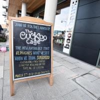
The blurb for The Cuckoo Cage sounds fun:
In this unique experiment, twelve authors have been tasked with resurrecting that tradition: to spawn a new generation of present-day British superheroes, willing to bring the fight back to British shores and to more progressive causes.
But I'd probably take issue with the experiment's claimed uniqueness, given that it sounds virtually the same concept as 1991's Temps. Still, I'll be interested to read it and I snapped this to remind myself that I might want to get a ticket for the launch.
Tags: Bristol Places UK onemilematt united kingdom Wapping Wharf Spike Island
Auto-Tags: Font Handwriting City Road surface Building Human settlement Advertising Signage Event Door Billboard Street Sidewalk Banner Facade
Text Recognition Tags: be aus JOIN US FOR THE LAUNCH OF The Cuckoo Cage THE NEW ANTHOLOGY THAT REIMAGINES WHAT WE SEE WHEN NE THINK SUPERHERO FEATURUKING A NEW SIOKY BY COURTTIA NEWLAND ON THE TorPLING OF COSTON MARCH 9 18-30-20 90-TKRETIES bookha175: be aus JOIN US FOR THE LAUNCH OF The Cuckoo Cage THE NEW ANTHOLOGY THAT REIMAGINES WHAT WE SEE WHEN NE THINK SUPERHERO FEATURUKING A NEW SIOKY BY COURTTIA NEWLAND ON THE TorPLING OF COSTON MARCH 9 18-30-20 90-TKRETIES bookha175:
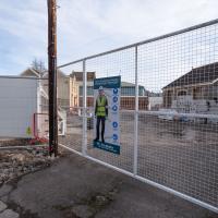
I think this is likely part of the development of the old brewery site into modern flats. Last I saw it was at least planned to be 100% affordable new homes, at least.
I mostly went out to hang out with my friends Sarah and Vik in Bedminster, but along the way I thought I'd take a closer look at something a little nearer home: the last crossing point of the Rownham Ferry.
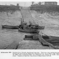
And here's the picture that inspired this little local visit today. A week or so back I was browsing the boxes of books at Rachel's and Michael's Antiques on Princess VIctoria Street, and flipping through their collection of Reece Winstone books. Winstone's famous Bristol As It Was series are an amazing documentary source created by a man who loved both photography and Bristol and effectively became Bristol's foremost documentary photographer for decades. A lot more of Bristol's history is visible today because of him.
In the Bristol As It Was 1939 - 1914 book I saw this picture of the Rownham Ferry. Unfortunately the book was a first edition and priced at £20, so I ordered a cheaper edition from an independent dealer in Stockport when I got home! (Let's consider that as me leaving the rare first edition for the true connoisseurs, rather than just being cheap.)
Here we see the ferry just five days before its closure on the last day of 1932. Looking closely, it seems to be perhaps operating as a reaction ferry, with the boat tethered to a static line across the river, and the ferryman using the rudder to turn the boat and use the power of the flowing water to shuttle the boat from side to side. Clever!
Photo © Reece Winstone Archive. (I recommend buying the books if you like old photos of Bristol. They're amazing!)
Tags: Bristol Places UK onemilematt united kingdom river avon avon new cut Spike Island history Rownham Ferry
Auto-Tags: Boat Water Watercraft Vehicle Naval architecture Boats and boating--Equipment and supplies Ship Motor vehicle History Monochrome Water transportation Stock photography Lake Monochrome photography Sky
Text Recognition Tags: (63) 26 December 1932 : Rownham Ferry, Hotwells, discontinued 5 days later. There was a river crossing here since Norman days and carried the Abbot of St. Augustine's on his way to Abbot's Leigh. Before the 1870's when Cumberland Basin was re-designed, the crossing was further down- stream. Dangerous at high tide, it was merely a bridge of boats at low tide. (63) 26 December 1932 : Rownham Ferry, Hotwells, discontinued 5 days later. There was a river crossing here since Norman days and carried the Abbot of St. Augustine's on his way to Abbot's Leigh. Before the 1870's when Cumberland Basin was re-designed, the crossing was further down- stream. Dangerous at high tide, it was merely a bridge of boats at low tide.
Easter Monday Gardens and Flowers
18 Apr 2022
I didn't really set out with a theme of flowers and gardens in mind for this walk. I just fancied heading up to Clifton Village to get lunch. As it turned out, though, Spring was springing, so a minor theme emerged as I started off with the graveyard flowers of Hope Chapel and wandered up to see the beginnings of the new wildflower garden at Clifton Hill Meadow.
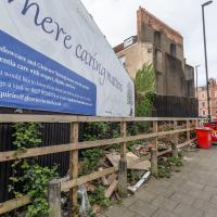
Where fly tipping happens, more like. This scrap of land (with a public bench hidden on the far end, against the back fence behind the red bins) has been a bit of an eyesore for years. I've never been a fan of public billboards.
Recently, though, a property developer has applied for planning permission for a block of flats here, and apparently fenced off the bit where the main entrance will be, even though it's fenced in this little corner of land that everyone assumed was public, council bench and all. And now it's attracted fly tippers, it seems.
I've tweeted at the councillor for the area, Alex Hartley, and he's said he's alerted the council and will try to investigate it/get it cleaned up, so here's hoping...
In the long run, maybe there will be some new flats instead of an ugly billboard and some dull fencing, and I'm all for that.
Tags: Bristol Places UK onemilematt united kingdom Hotwells hotwell road Dowry Parade Chapel Row billboard fly tipping ugly
Auto-Tags: Plant Sky Building Window Cloud House Billboard Urban design Fence Car Real estate Asphalt Facade Road City
Text Recognition Tags: nere caring man Meadowcare and Glenview Nuning dementia care with respect, digita If you would like to know more abows arrange a visit on 0117 973 0174 or cal or enquiries@glenview bristolak S nere caring man Meadowcare and Glenview Nuning dementia care with respect , digita If you would like to know more abows arrange a visit on 0117 973 0174 or cal or enquiries @ glenview bristolak S
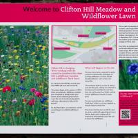
Tags: Bristol Places UK onemilematt united kingdom Clifton Village Clifton Clifton Hill Clifton Hill Bank Clifton Hill Meadow
Auto-Tags: Plant community Ecoregion Plant Green Natural landscape Natural environment Botany Organism Terrestrial plant Vegetation Land lot Grass Font Biome Line
Text Recognition Tags: Welcome to Clifton Hill Meadow and Wildflower Lawn We to add which grobe Theate h how to w 2001. The c wakenya March 2002. Over t 0 flow and fy ata of t What will happen on the site Clifton Hill is changing We're working with the council to transform this slope www into a wildflower meadow and wildflower floral law. betrie Espress but we will soon stat The week and the grap prothesof 2011 Feyete the C when we propawower made the becomes to fe of powiad of coa tour, de dona pm the cap sed my led to help on the gord They are w Swach the So that owner, and the ம து போட்ட விலொ That the be wh Apinating w the to the we Do you want mor wildflowers? DVD WEST BRISTOL CLIMATE Welcome to Clifton Hill Meadow and Wildflower Lawn We to add which grobe Theate h how to w 2001. The c wakenya March 2002 . Over t 0 flow and fy ata of t What will happen on the site Clifton Hill is changing We're working with the council to transform this slope www into a wildflower meadow and wildflower floral law . betrie Espress but we will soon stat The week and the grap prothesof 2011 Feyete the C when we propawower made the becomes to fe of powiad of coa tour , de dona pm the cap sed my led to help on the gord They are w Swach the So that owner , and the ம து போட்ட விலொ That the be wh Apinating w the to the we Do you want mor wildflowers ? DVD WEST BRISTOL CLIMATE
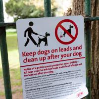
There's been some commotion on Nextdoor about the recent appearance of this sign. Lots of people who have been letting their dogs off their leads in the churchyard for decades have been rather up in arms. I'm not sure there's actually much danger of the rozzers issuing ASBOs or fines to the locals for that kind of infraction, though.
Tags: Bristol Places UK onemilematt united kingdom Clifton Village Clifton St Andrew's churchyard birdcage walk Lime Walk
Auto-Tags: Green White Nature Natural environment Grass Font Biome Line Plant Public space Woody plant Tree Signage Motor vehicle Street sign
Text Recognition Tags: ㅅ Keep dogs on leads and clean up after your dog Notice of a public spaces protection order (PSPO)- All dogs must be held on leads and it is an offence not to clean up after your dog Anti-Social Behaviour Crime And Policing Act 2014, Section 59Notice is hereby given that Bristol City Council (the Council) in exercise of its powers under Section 59, 63 and 72 of the Anti-social Behaviour, Crime and Policing Act 2014 The Act, being satisfied that the conditions set out in section 59 of the Act have been met, made the following Onder City Of Bristol (Dog Control) Public Spaces Protection Order 2020. A Fored Penalty Notice may be issued to a person who a comitable or authorised person has reason to believe has committed an offence in relation to this One offering the person to whom it is issued the opportunity of dischinging any lability to conviction for the offence by payment of a fiend penalty Scene dog fouling provisions and the Exclusion Zones de not app assistance dogs Further information about the PSPO and the front of the Onder can be found at Public Space Protection (PSPO)-bristol.gov.uk ㅅ Keep dogs on leads and clean up after your dog Notice of a public spaces protection order ( PSPO ) All dogs must be held on leads and it is an offence not to clean up after your dog Anti - Social Behaviour Crime And Policing Act 2014 , Section 59Notice is hereby given that Bristol City Council ( the Council ) in exercise of its powers under Section 59 , 63 and 72 of the Anti - social Behaviour , Crime and Policing Act 2014 The Act , being satisfied that the conditions set out in section 59 of the Act have been met , made the following Onder City Of Bristol ( Dog Control ) Public Spaces Protection Order 2020 . A Fored Penalty Notice may be issued to a person who a comitable or authorised person has reason to believe has committed an offence in relation to this One offering the person to whom it is issued the opportunity of dischinging any lability to conviction for the offence by payment of a fiend penalty Scene dog fouling provisions and the Exclusion Zones de not app assistance dogs Further information about the PSPO and the front of the Onder can be found at Public Space Protection ( PSPO ) -bristol.gov.uk
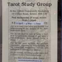
From the window of the community bookshop. A book I'm vaguely thinking of writing involves the Tarot, and I'm a little tempted to go on this.
Tags: Bristol Places UK onemilematt united kingdom Clifton Village Clifton Clifton Community Bookshop
Auto-Tags: Font Material property Publication Paper Signage Handwriting Document Electric blue Engineering Transport Advertising Commemorative plaque History Ink Paper product
Text Recognition Tags: Dublum Filwind Tickets £10, available on Eventbrite or on the door XIXS Tarot Study Group At the Clifton Community Bookshop 10 Clifton Road, Bristol, BS8-1AF First Wednesday of every month 6:00-7:30pm 5 Ja 6 April-4 May - 1 June rch Join us to share your ideas and develop your understanding of the imagery of the Rider- Waite-Smith Tarot. You do not need to own or bring a Tarot deck to participate (though if you have a Rider-Waite-Smith deck please bring it along). Aly You do not need to have any previous experience, expertise or understanding of the cards just imagination, Interest, and willingness to exercise your intuition. 25 per evening, including a small token and a chance to win a Tarot-related book For more information please contact tarotstudy@pobroadband.co.uk THE THE SUN Dublum Filwind Tickets £ 10 , available on Eventbrite or on the door XIXS Tarot Study Group At the Clifton Community Bookshop 10 Clifton Road , Bristol , BS8-1AF First Wednesday of every month 6 : 00-7 : 30pm 5 Ja 6 April - 4 May - 1 June rch Join us to share your ideas and develop your understanding of the imagery of the Rider Waite - Smith Tarot . You do not need to own or bring a Tarot deck to participate ( though if you have a Rider - Waite - Smith deck please bring it along ) . Aly You do not need to have any previous experience , expertise or understanding of the cards just imagination , Interest , and willingness to exercise your intuition . 25 per evening , including a small token and a chance to win a Tarot - related book For more information please contact tarotstudy@pobroadband.co.uk THE THE SUN
Ticking Off a Pocket of Paths in Leigh Woods
03 Jun 2022
I managed to go for a wander a while ago that was meant to finish off a little tangle of paths in Leigh Woods, or at the very least finish off my wandering of the Purple Path there. And I managed to miss doing either of those things through some kind of navigational incompetence.
Today I woke up with a bit of a headache, feeling a bit knackered as soon as I dragged myself out of bed, but at least with the energy to realise that I'd be better off (a) going for a walk in what looked likely to be the last of the Jubilee weekend sunshine than (b) moping around the flat until it started raining, at which point I could mope more thoroughly.
I had a look at my map, considered going to Ashton Court, but remembered that there was a music festival there today, and instead found these little leftovers of Leigh Woods and decided to have one more try at walking them.
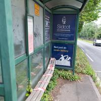
I imagine the delighted customer who emplaced the previous missive on the end of the shelter had stood here for a significant portion of their life. Well, that's often how I end up feeling while waiting for a bus in Bristol.
Sidcot School, advertised at the end there, is one of only seven Quaker-run schools in England, founded 1699, situated in the Mendips. A fee-charging school, they do of course have a network of their own minibus services—ten routes in total—to ferry the kids there and back, so they probably don't have to wait for First to turn up.
Tags: Bristol Places UK onemilematt united kingdom Rownham Hill
Auto-Tags: Plant Building Tree Vehicle Shade Car Road Sidewalk Grass City House Wheel Motor vehicle Signage Advertising
Text Recognition Tags: ON Sidcot Live Adventurously Not just an exam factory ON Sidcot Live Adventurously Not just an exam factory
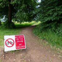
Guessing this is a polite hint from the golf club. In my mind's eye I can see an irate greenkeeper chasing a couple of mountain bikers in his golf buggy.
Tags: Ashton Court Estate Bristol Places UK onemilematt united kingdom ashton court
Auto-Tags: Plant Plant community Natural landscape Tree Land lot Road surface Asphalt Grass Woody plant Traffic sign Landscape Groundcover Shrub Recreation Road
Text Recognition Tags: NO BIKES ON THE GRASS NO EXCUSES NO BIKES ON THE GRASS NO EXCUSES
Tags: Ashton Court Estate Bristol Places UK onemilematt united kingdom ashton court conservation skylark
Auto-Tags: Bird Plant community Vertebrate Ecoregion Nature Beak Mammal Grass Adaptation Grassland Grass family Terrestrial plant Groundcover Feather Plant
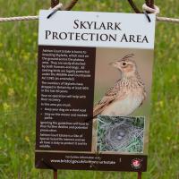
Text Recognition Tags: SKYLARK PROTECTION AREA Ashton Court Estate is home to breeding Skylarks, which nest on the ground across the plateau area. They are easily disturbed by both humans and dogs. All nesting birds are legally protected under the Wildlife and Countryside Act 1981 (as amended) The numbers of Skylarks have dropped in Britain by at least 60% in the last 40 years Your co-operation will help with their recovery In this area you must: + Keep your dog on a short lead Stay on the mown and marked paths. ignoring the guidelines will lead to their further decline and potential prosecution. Ashton Court Estate is a Site of Special Scientific interest and we all have a duty to protect it and its wildlife. For further information vit www.bristol.gov.ukychtoncourtestate SKYLARK PROTECTION AREA Ashton Court Estate is home to breeding Skylarks , which nest on the ground across the plateau area . They are easily disturbed by both humans and dogs . All nesting birds are legally protected under the Wildlife and Countryside Act 1981 ( as amended ) The numbers of Skylarks have dropped in Britain by at least 60 % in the last 40 years Your co - operation will help with their recovery In this area you must : + Keep your dog on a short lead Stay on the mown and marked paths . ignoring the guidelines will lead to their further decline and potential prosecution . Ashton Court Estate is a Site of Special Scientific interest and we all have a duty to protect it and its wildlife . For further information vit www.bristol.gov.ukychtoncourtestate
A Quick Swing Past Ashton Court
05 Jun 2022
Another day not dissimilar to my last wander: I'm feeling a bit tired and rather than just moping around the house I thought I'd find some tiny bit of somewhere that I'd not yet walked and get outdoors. This time I headed for the Tobacco Factory Market in Bedminster, as I often do, but went the long way around via Ashton Court Mansion as I knew there were some footpaths and a small section of road I'd not ticked off up there. Finishing all the Ashton Court footpaths will be quite a long job, but you've got to start somewhere...
I did feel rather better by the time I got home, and, pretty much astoundingly given the weather forecast, managed to avoid the rain completely.
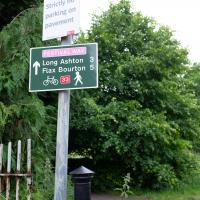
I like the sound of "Flax Bourton". I keep on meaning to dust off my bike; maybe a trip along there would be an interesting day trip. Might want to make sure I can still ride comfortably before I try a ten-mile round trip, though...
Tags: Ashton Court Estate Bristol Places UK onemilematt united kingdom ashton court
Auto-Tags: Plant Motor vehicle Natural landscape Land lot Tree Grass Thoroughfare Woody plant Waste container Street sign Landscape Road Shrub Pole Signage
Text Recognition Tags: Strictly parking on pavement FESTIVAL WAY Long Ashton 3 Flax Bourton 5 Strictly parking on pavement FESTIVAL WAY Long Ashton 3 Flax Bourton 5
I've been pretty awful at reading so far this year, apparently averaging about one book per month. That's a far cry from 2019, say, where I got through 41 books in the year. Today's wander was prompted by my rubbish reading, as I needed to go hand back some books to the library, because I'd managed to renew them so many times that I hit the limit on renewals. Oops. Several of them were still unread.
So, off to the Central Library for me, tail between my legs. On the way there I did my best to recreate a historical photo of Dowry Square; while I was in the area I walked under the adjacent Norman arch and poked around behind the Cathedral, and I also had a little diversion to the city centre and came back along the south side of the river, hitting some trouble with the lock gates as I finally crossed the harbour back towards home.
Tags: Bristol Places UK onemilematt united kingdom City Centre St Augustine's Cathedral Choir School Cathedral School college square
Auto-Tags: Font Rectangle Pink Material property Magenta Publication Pattern Wood Carmine Paper Paper product Commemorative plaque Signage Circle History
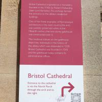
Text Recognition Tags: Abbot's Gatehouse Bristol Cathedral originated as a monastery founded in the 1140s by Robert Fitzharding (later Lord Berkeley) This archway formed the entrance to the abbey's residential buildings One of the finest examples of Romanesque architecture in the west country, the arch was carefully preserved when, in the fifteenth century, the two-storey gatehouse was constructed over it. The medieval statues on the gatehouse depict key individuals in the history of the abbey, which was disbanded in 1539. Bristol Cathedral was founded in 1542 and the gatehouse today contains its administrative offices. Bristol Cathedral Entrance to the cathedral is via the North Porch through the arch and to the right SHAND 200 ACER B HODERN Abbot's Gatehouse Bristol Cathedral originated as a monastery founded in the 1140s by Robert Fitzharding ( later Lord Berkeley ) This archway formed the entrance to the abbey's residential buildings One of the finest examples of Romanesque architecture in the west country , the arch was carefully preserved when , in the fifteenth century , the two - storey gatehouse was constructed over it . The medieval statues on the gatehouse depict key individuals in the history of the abbey , which was disbanded in 1539 . Bristol Cathedral was founded in 1542 and the gatehouse today contains its administrative offices . Bristol Cathedral Entrance to the cathedral is via the North Porch through the arch and to the right SHAND 200 ACER B HODERN
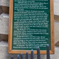
A bit more detail if you fancy it.
Tags: Bristol Places UK onemilematt united kingdom City Centre Saint Nicholas Market St Nicholas Market St. Nicholas Market Corn Street old city
Auto-Tags: Wood Font Wall Landmark Commemorative plaque Tree History Signage Memorial Metal Public utility Interior design Kitchen utensil Idiophone
Text Recognition Tags: THE CORN EXCHANGE CLOCK The clock on this building with an extra minute hand recalls early Victorian days, when Bristol was in two minds about the correct time. Although today we take Greenwich Mean Time or British Summertime for granted before 1880 no standard time existed in the British Isles. Every city had its own local time, reckoned by the sun and signed by church bells. Bristol lies 2 degrees, 36 minutes west of the Greenwich Meridian and so the sun reaches its noon nearly peak 11 minutes later than in Greenwich. Before the growth of railways, most people expected to spend their lives close to home. Travel by stagecoach or ship was slow and uncomfortable. Timetables were vague. For Bristolians a change came in June 1841, when the first through train from London pulled into Temple Meads Station. Brunel's Great Western Railway began to tempt people to travel, now they could go to London in hours rather than days. The Railways ran on London time (Greenwich Mean Time). If you wanted to catch a train at noon from Temple Meads you had to remember that it would pull out at 11:49 Bristol Time. To help Bristolians catch their trains, Bristol Corporation arranged for the main public clock on the Corn Exchange to show both local and Greenwich Mean Time (Railway Time) with two minute hands. Other clocks in Bristol adopted the same compromise, In September 1852 Bristol adopted GMT and Bristol time became the same as Lond THE CORN EXCHANGE CLOCK The clock on this building with an extra minute hand recalls early Victorian days , when Bristol was in two minds about the correct time . Although today we take Greenwich Mean Time or British Summertime for granted before 1880 no standard time existed in the British Isles . Every city had its own local time , reckoned by the sun and signed by church bells . Bristol lies 2 degrees , 36 minutes west of the Greenwich Meridian and so the sun reaches its noon nearly peak 11 minutes later than in Greenwich . Before the growth of railways , most people expected to spend their lives close to home . Travel by stagecoach or ship was slow and uncomfortable . Timetables were vague . For Bristolians a change came in June 1841 , when the first through train from London pulled into Temple Meads Station . Brunel's Great Western Railway began to tempt people to travel , now they could go to London in hours rather than days . The Railways ran on London time ( Greenwich Mean Time ) . If you wanted to catch a train at noon from Temple Meads you had to remember that it would pull out at 11:49 Bristol Time . To help Bristolians catch their trains , Bristol Corporation arranged for the main public clock on the Corn Exchange to show both local and Greenwich Mean Time ( Railway Time ) with two minute hands . Other clocks in Bristol adopted the same compromise , In September 1852 Bristol adopted GMT and Bristol time became the same as Lond
Nipping Up the Zig Zag to the Shops
19 Aug 2023
It's been a long while since I did one of these walks.
I'm thinking of finishing up the project by walking one or two last bits of road, thus being able to declare with all honesty that I've done my best to walk every public road within my mile (and quite a few alleyways besides.) As a prelude, and just because I felt like it, I decided to drag out the camera and GPS on this little wander to the local shops.

Also looking nice and fresh since my last wander is the pair of community noticeboards, with a plethora of local news.
I found out recently that I was a winnner of one of the Hotwells & Cliftonwood Community Association 500 club prizes, which, alongside my membership, is a fun way to give money to the local organisation that puts up these noticeboards and does so much else for the community.
Tags: Bristol Places UK onemilematt united kingdom Clifton Village Hotwells Clifton
Auto-Tags: Poster Font Advertising Picture frame Signage Display board Event Wood Facade Publication Transport Landscape Banner Art
Text Recognition Tags: Howells and Cliftonwood Community Association (ACCA) community cond Useful local information Cond Local Pang Vefa Avon and R Ay GTA abyQMalaw De Oy He PO De 30 G F PAD Lesson for t FRA Obag w BATANGA to your whatapang Var JOE MICKS GUITAR TEACHER BUTHORE.COM y Gramgenee07504 ty PO Box 200 Online Coaching and 61100 TW utrition Quidance Fra ersonal Training sessions LONDRE om prope tech y and get aang d 222000 Get Fit, Be Healthier, Be The Best Version Of You! www.top be and reach SOF ing out to Our sto Quran We have ww Facebook Tutir @COtt G35 Top for my on or stop you A O 07564375433 @w tabourside and Satu Action Fraud ALERT AF Google .***. of St DAS y Th y AudionFraud SA 13304 W 15. Ch Lifeskitts LEARNING FOR LIVING Guing which includes working wilt amal and active safatyti Wysan bes the fe WELCOME SPACE at CLIFTON LIBRARY activitating January 2635 (10 ng WELCOME SPACE We are currently looking for people to help us deliver safety education to children via our enginteractive village based in central Bristol www50 Hotwells & Cliftonwood Community Association 500 CLUB RESULTS 2023 1 mn m Hot drinks Relax GAMES CRAFTING Films CHAT Wellbeing Newspapers Study KAPHY TABLE TENNIS Hasting which includes opening and sing talk with the c sporting teachers re The 100 Challe Join us for a tester heut Wednesday 12th April is the next scheduled taster hour please contact the email below for more information and to book your place OLLYW4 Hvat e ang pag Apt Now swight Robert C con Nowhe CIP ad NC Nowe Man No for 2 yr y dece ww OXO AUTY New THANK YOU TO ALL OF THE YOUR 300C SUCTIONS A HANG POSLE POES THAT HELPO THE LOCALE EVERY MONTH WE HAVE UNCLAIMED PRIZE HONEY THAT COULD YOUR CLUB FOR THE CHANCE TO BE YOU NAM NAD OF NO WINNER OWN AND SUPPORT THE WORK OF YOUR LOCAL COMMUNITY SCAN ME bile PR COURE Ap C Te qu 700 Emetas T Com You to t You fost d Shpaloaph we would love to make oef regularly vegade ba ne Beinart Art & Art haling p A you missing making an DEMENTIA SAFEGUARDING SCHEMEL www.beinartotive.c 4 Ben sad fin BEWARE PROSITY Criminals are adapting! there are many where you ca weket M -Tudo que fa thoshwade - pada poleg oniks and li MA ART whick - server creaty PCRIME and the deving the vers If you're not sure, research more! www Having a baby? - PRACTICAL and EMOTIONAL support is available for you in the cala in pomancy, birth and pomnically Sear Roma Helen Whit ANME PROCITY O Howells and Cliftonwood Community Association ( ACCA ) community cond Useful local information Cond Local Pang Vefa Avon and R Ay GTA abyQMalaw De Oy He PO De 30 G F PAD Lesson for t FRA Obag w BATANGA to your whatapang Var JOE MICKS GUITAR TEACHER BUTHORE.COM y Gramgenee07504 ty PO Box 200 Online Coaching and 61100 TW utrition Quidance Fra ersonal Training sessions LONDRE om prope tech y and get aang d 222000 Get Fit , Be Healthier , Be The Best Version Of You ! www.top be and reach SOF ing out to Our sto Quran We have ww Facebook Tutir @COtt G35 Top for my on or stop you A O 07564375433 @w tabourside and Satu Action Fraud ALERT AF Google . *** . of St DAS y Th y AudionFraud SA 13304 W 15. Ch Lifeskitts LEARNING FOR LIVING Guing which includes working wilt amal and active safatyti Wysan bes the fe WELCOME SPACE at CLIFTON LIBRARY activitating January 2635 ( 10 ng WELCOME SPACE We are currently looking for people to help us deliver safety education to children via our enginteractive village based in central Bristol www50 Hotwells & Cliftonwood Community Association 500 CLUB RESULTS 2023 1 mn m Hot drinks Relax GAMES CRAFTING Films CHAT Wellbeing Newspapers Study KAPHY TABLE TENNIS Hasting which includes opening and sing talk with the c sporting teachers re The 100 Challe Join us for a tester heut Wednesday 12th April is the next scheduled taster hour please contact the email below for more information and to book your place OLLYW4 Hvat e ang pag Apt Now swight Robert C con Nowhe CIP ad NC Nowe Man No for 2 yr y dece ww OXO AUTY New THANK YOU TO ALL OF THE YOUR 300C SUCTIONS A HANG POSLE POES THAT HELPO THE LOCALE EVERY MONTH WE HAVE UNCLAIMED PRIZE HONEY THAT COULD YOUR CLUB FOR THE CHANCE TO BE YOU NAM NAD OF NO WINNER OWN AND SUPPORT THE WORK OF YOUR LOCAL COMMUNITY SCAN ME bile PR COURE Ap C Te qu 700 Emetas T Com You to t You fost d Shpaloaph we would love to make oef regularly vegade ba ne Beinart Art & Art haling p A you missing making an DEMENTIA SAFEGUARDING SCHEMEL www.beinartotive.c 4 Ben sad fin BEWARE PROSITY Criminals are adapting ! there are many where you ca weket M -Tudo que fa thoshwade - pada poleg oniks and li MA ART whick - server creaty PCRIME and the deving the vers If you're not sure , research more ! www Having a baby ? - PRACTICAL and EMOTIONAL support is available for you in the cala in pomancy , birth and pomnically Sear Roma Helen Whit ANME PROCITY O
More notices, including a couple of newcomers to the local businesses: Hopewell, an estate agency, has opened up just down Hopechapel Hill in the place of The Landmark Practice (an environmental consultancy firm that seem to have moved out to Long Ashton) and HappyBack, who I'd noticed appearing down on the Hotwell Road a month or two ago.
Tags: Bristol Places UK onemilematt united kingdom Clifton Village Hotwells Clifton
Auto-Tags: Poster Font Gas Signage Advertising Facade Display board Billboard Town City Machine Transport
Text Recognition Tags: SAVE JACOBS WELLS your We W ty WS Na à Order w a gratyf Lauan ya wld worldcat HERE THE PETI Cale wwwwww CHBUEC C www d Dabe 17 TANTO F www. 0-100 Your journey is our journey and we are here to help you every step of the way Wend fpwith vir Ourica apteert papper mating nything t neces or Sc ng vs Shack and petere p FM 2 yan unteers Needed 0/0 70-23 DAN HappyBack Find Ho D Highly experienced Physiotherapy. Osteopathy and H® Massage specialists, helping you to get your happy back! W Lifeskills Lifeskills Learning for Living Py Acad Marg back. people to join our amazing toomer volunteers Oxime ww We are your new neighbours! pelare a prsity independent state aguny tinging together every best o ort, medium Alongtam ss and mes for sale across the city ravis A NEW Ma # HOPEWELL Come and say hello at our new offic orated at Hope Chcel House Hone Chapel Hill BSB IND 0117 911 8663 CERED ww are acest (10-only) og for new SANT FREE PEER SUPPORT GROUP TUESDAYS ONLINE 6.30-8.30pm 24ury Facilitated by LGBTQIA people Safe, nonjudgemental, confidential space to discuss mental wellbeing with other LGSTOLA+people Trinity Lunch Club Thursdays 10am-3:30pm Morning Coffee Armchair Excises 3 Course Home Cooked Lunch CET ARTIN Quiz Activities Tea & Biscuits For more information Call 07458 300 210 or email tes@holytrinityhotwells.org Holy Trinity Church serving the communities of Hotwells, Cliftonwood, Saike Island, Harboursie holytrinityhotwells.org Alexander May Having a baby? 42- AU You and your birth partner weinstela Calm Births Hypnobirthing FREE TASTER SESSION, online with Dolanan Monday th September OXO 7.30pm P By placeb www.dealbws.com We are devastated by the fire at the Underfall Yard. fre The fee has destroyed the heart of the Yard where most of the boat building activity takes place and tenant's businesses and boats have. been ruined. Thankfully no one was killed and no on was injured, but a lot of people in the Underfall Yard community have been impacted our staff, our tenants, our volunteers and our neighbours on Avon Crescent and Nova Scotia Place. Our hearts are with them and we are supporting our tenants as best we can. P DARO l HIER UNDERFALL YARD TRUST The Underfall Yard Trust was formed i the 1990's to bring the Underfall Yard out of dereliction, to look after the historio buildings, to shine a light on Bristoll's engineering harbour heritage and to promote traditional marine skills. In light of the devastation at the Yard, those aims remain as relevant now as they were then, SE We absolutely are committed to rebuilding the Underfall Yard and continuing the charity's work, If you would like to support the Trust, please see our JustGiving page, scan the QR code or alternatively, there is a donation box located on the Café till. https://www.justgiving.com/theunderfallyardtrust SAVE JACOBS WELLS your We W ty WS Na à Order w a gratyf Lauan ya wld worldcat HERE THE PETI Cale wwwwww CHBUEC C www d Dabe 17 TANTO F www . 0-100 Your journey is our journey and we are here to help you every step of the way Wend fpwith vir Ourica apteert papper mating nything t neces or Sc ng vs Shack and petere p FM 2 yan unteers Needed 0/0 70-23 DAN HappyBack Find Ho D Highly experienced Physiotherapy . Osteopathy and H® Massage specialists , helping you to get your happy back ! W Lifeskills Lifeskills Learning for Living Py Acad Marg back . people to join our amazing toomer volunteers Oxime ww We are your new neighbours ! pelare a prsity independent state aguny tinging together every best o ort , medium Alongtam ss and mes for sale across the city ravis A NEW Ma # HOPEWELL Come and say hello at our new offic orated at Hope Chcel House Hone Chapel Hill BSB IND 0117 911 8663 CERED ww are acest ( 10 - only ) og for new SANT FREE PEER SUPPORT GROUP TUESDAYS ONLINE 6.30-8.30pm 24ury Facilitated by LGBTQIA people Safe , nonjudgemental , confidential space to discuss mental wellbeing with other LGSTOLA + people Trinity Lunch Club Thursdays 10 am-3:30pm Morning Coffee Armchair Excises 3 Course Home Cooked Lunch CET ARTIN Quiz Activities Tea & Biscuits For more information Call 07458 300 210 or email tes@holytrinityhotwells.org Holy Trinity Church serving the communities of Hotwells , Cliftonwood , Saike Island , Harboursie holytrinityhotwells.org Alexander May Having a baby ? 42 AU You and your birth partner weinstela Calm Births Hypnobirthing FREE TASTER SESSION , online with Dolanan Monday th September OXO 7.30pm P By placeb www.dealbws.com We are devastated by the fire at the Underfall Yard . fre The fee has destroyed the heart of the Yard where most of the boat building activity takes place and tenant's businesses and boats have . been ruined . Thankfully no one was killed and no on was injured , but a lot of people in the Underfall Yard community have been impacted our staff , our tenants , our volunteers and our neighbours on Avon Crescent and Nova Scotia Place . Our hearts are with them and we are supporting our tenants as best we can . P DARO l HIER UNDERFALL YARD TRUST The Underfall Yard Trust was formed i the 1990's to bring the Underfall Yard out of dereliction , to look after the historio buildings , to shine a light on Bristoll's engineering harbour heritage and to promote traditional marine skills . In light of the devastation at the Yard , those aims remain as relevant now as they were then , SE We absolutely are committed to rebuilding the Underfall Yard and continuing the charity's work , If you would like to support the Trust , please see our JustGiving page , scan the QR code or alternatively , there is a donation box located on the Café till . https://www.justgiving.com/theunderfallyardtrust