Tagged: font
Ticking Off a Pocket of Paths in Leigh Woods
03 Jun 2022
I managed to go for a wander a while ago that was meant to finish off a little tangle of paths in Leigh Woods, or at the very least finish off my wandering of the Purple Path there. And I managed to miss doing either of those things through some kind of navigational incompetence.
Today I woke up with a bit of a headache, feeling a bit knackered as soon as I dragged myself out of bed, but at least with the energy to realise that I'd be better off (a) going for a walk in what looked likely to be the last of the Jubilee weekend sunshine than (b) moping around the flat until it started raining, at which point I could mope more thoroughly.
I had a look at my map, considered going to Ashton Court, but remembered that there was a music festival there today, and instead found these little leftovers of Leigh Woods and decided to have one more try at walking them.
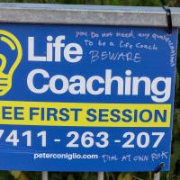
It's quite the commentary. But then if someone believes they can have their life turned around by a fly-posting stranger, perhaps a warning is a reasonable addendum.
Tags: Bristol Places UK onemilematt united kingdom Ashton Ashton Avenue Bridge Rownham
Auto-Tags: Plant Natural landscape Font Grass Landscape Groundcover Signage Rectangle Advertising Poster Street sign Sign Nature reserve Tree Banner
Text Recognition Tags: you Do not need any qualifi To be a Life Coach Life BEWARE Coaching FREE FIRST SESSION 07411-263-207 peterconiglio.com IAL AT OWN RISK CU you Do not need any qualifi To be a Life Coach Life BEWARE Coaching FREE FIRST SESSION 07411-263-207 peterconiglio.com IAL AT OWN RISK CU

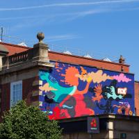
Tags: Bristol Places UK onemilematt united kingdom graffiti street art DazCat
Auto-Tags: Plant Paint Graffiti Art Tree Public space Painting Mural Artist Font Facade Visual arts Drawing Illustration Door
Text Recognition Tags: WAY NAZCAT NA LGG WAY NAZCAT NA LGG
This is a sentiment that I've often shared, I confess, but never been motivated to express in the form of paint.
Tags: Bristol Places UK onemilematt united kingdom Rownham Hill
Auto-Tags: Telephone booth Plant Motor vehicle Tree Grass Font Gas Handwriting Signage Sign Advertising Wood Nature reserve Art Machine
Text Recognition Tags: Ashton Court GUT Tegn Sub Ashton Court GUT Tegn Sub
A Quick Swing Past Ashton Court
05 Jun 2022
Another day not dissimilar to my last wander: I'm feeling a bit tired and rather than just moping around the house I thought I'd find some tiny bit of somewhere that I'd not yet walked and get outdoors. This time I headed for the Tobacco Factory Market in Bedminster, as I often do, but went the long way around via Ashton Court Mansion as I knew there were some footpaths and a small section of road I'd not ticked off up there. Finishing all the Ashton Court footpaths will be quite a long job, but you've got to start somewhere...
I did feel rather better by the time I got home, and, pretty much astoundingly given the weather forecast, managed to avoid the rain completely.
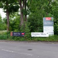
Ah, so not only is it the Bristol Triathlon next weekend, but it's also the UWE degree show. That's usually worth a look-see. Mind you, it's also Clifton Open Gardens, so maybe I'll see what the weather's like before I make a choice. UWE's Bower Ashton campus can be absolutely sweltering on a warm day, from what I remember, so I might be better off sipping Pimms in a garden if it's too sunny.
Tags: Ashton Court Estate Bristol Places UK onemilematt united kingdom ashton court
Auto-Tags: Plant Tree Motor vehicle Road surface Asphalt Thoroughfare Grass Tar Gas Landscape Road Signage Public utility Font City
Text Recognition Tags: Open Day LIVE BU City Campus at Bower Ashton Degree Show Open Day LIVE BU City Campus at Bower Ashton Degree Show
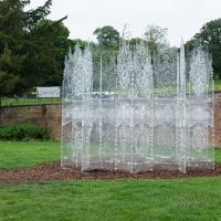
Trasparenza, by Andrea Greenlees, originally built for Burning Man in 2016. It has transparent benches inside, but it looked a bit of a tight squeeze, so I left the children of the family that arrived a couple of minutes later to it. They seemed to enjoy exploring. There's a view from the inside on Andrea's Instagram.
Tags: Ashton Court Estate Bristol Places UK onemilematt united kingdom ashton court sculpture Andrea Greenlees installation
Auto-Tags: Water Plant Sky Tree Land lot Grass Natural landscape Fountain Shrub Landscape Groundcover Art Grass family Lawn Font
Text Recognition Tags:
I think the Latin edging the doorway is "Pulchritudo Est Aliquid Incorporeum": "Beauty is an incorporeal thing", near as I can make out.
Tags: Ashton Court Estate Bristol Places UK onemilematt united kingdom ashton court sculpture Andrea Greenlees installation
Auto-Tags: Water Liquid Fluid Fountain Architecture Font Wall Art Glass Urban design Symmetry Tints and shades Grass Water feature Transparent material
Text Recognition Tags: ელები. * IE მაგიის "1" ელები . * IE მაგიის " 1 "

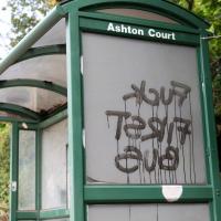
People have been telling me I'd enjoy Peep Show since it first came out in 2003. Nineteen years later anonymous daubers are still making the exhortation at me...
Wikipedia notes "The television series has been considered one of the best ever produced in the 21st century", so perhaps I should give it yet another try.
Tags: Bristol Places UK onemilematt united kingdom Ashton graffiti street art underapass Peep Show
Auto-Tags: Handwriting Paint Font Graffiti Tints and shades Writing Visual arts Art Concrete Drawing Street art Mural Magenta Illustration Art paint
Text Recognition Tags: -∞ WATCH PEEP SHOW OOR3 m x MY AL -∞ WATCH PEEP SHOW OOR3 m x MY AL
I've been pretty awful at reading so far this year, apparently averaging about one book per month. That's a far cry from 2019, say, where I got through 41 books in the year. Today's wander was prompted by my rubbish reading, as I needed to go hand back some books to the library, because I'd managed to renew them so many times that I hit the limit on renewals. Oops. Several of them were still unread.
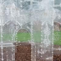
So, off to the Central Library for me, tail between my legs. On the way there I did my best to recreate a historical photo of Dowry Square; while I was in the area I walked under the adjacent Norman arch and poked around behind the Cathedral, and I also had a little diversion to the city centre and came back along the south side of the river, hitting some trouble with the lock gates as I finally crossed the harbour back towards home.
Tags: Bristol Places UK onemilematt united kingdom City Centre St Augustine's Cathedral Choir School Cathedral School college square
Auto-Tags: Font Rectangle Pink Material property Magenta Publication Pattern Wood Carmine Paper Paper product Commemorative plaque Signage Circle History
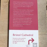
Text Recognition Tags: Abbot's Gatehouse Bristol Cathedral originated as a monastery founded in the 1140s by Robert Fitzharding (later Lord Berkeley) This archway formed the entrance to the abbey's residential buildings One of the finest examples of Romanesque architecture in the west country, the arch was carefully preserved when, in the fifteenth century, the two-storey gatehouse was constructed over it. The medieval statues on the gatehouse depict key individuals in the history of the abbey, which was disbanded in 1539. Bristol Cathedral was founded in 1542 and the gatehouse today contains its administrative offices. Bristol Cathedral Entrance to the cathedral is via the North Porch through the arch and to the right SHAND 200 ACER B HODERN Abbot's Gatehouse Bristol Cathedral originated as a monastery founded in the 1140s by Robert Fitzharding ( later Lord Berkeley ) This archway formed the entrance to the abbey's residential buildings One of the finest examples of Romanesque architecture in the west country , the arch was carefully preserved when , in the fifteenth century , the two - storey gatehouse was constructed over it . The medieval statues on the gatehouse depict key individuals in the history of the abbey , which was disbanded in 1539 . Bristol Cathedral was founded in 1542 and the gatehouse today contains its administrative offices . Bristol Cathedral Entrance to the cathedral is via the North Porch through the arch and to the right SHAND 200 ACER B HODERN
"Porter's lodge and gateway to Augustinian monastery, now school. Mid C12 archway in C17 house, rebuilt mid C20", says the listing.
Tags: Bristol Places UK onemilematt united kingdom City Centre St Augustine's Cathedral Choir School Cathedral School college square
Auto-Tags: Wood Building Font Tints and shades Art Arch Facade Symmetry Column Landscape Artifact Carving Holy places History Ancient history
Text Recognition Tags: 바구 1939 1945 바구 1939 1945

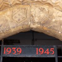
Pause for a moment first to admire the frieze and the acanthus-topped columns, but then check out the clock. It's not far off the right time, which is unusual for a public clock these days. But even a broken clock is right twice a day, right? Not this one—it would still be right four times a day, as it's got an extra minute hand. Before time was standardised across the country, this clock would show both local time and "Railway Time", i.e. Greenwich Mean Time.
It's directly over the entrance to Saint Nicholas Market, formely the Corn Exchange, but sadly they're closed on Sundays, so I couldn't take my usual wander through.
Tags: Bristol Places UK onemilematt united kingdom architecture City Centre Saint Nicholas Market St Nicholas Market St. Nicholas Market clock Corn Street old city
Auto-Tags: Daytime Property Window Building Clock Line Material property Font City Symmetry Facade Clock tower Metropolitan area Brickwork Medieval architecture
A bit more detail if you fancy it.
Tags: Bristol Places UK onemilematt united kingdom City Centre Saint Nicholas Market St Nicholas Market St. Nicholas Market Corn Street old city
Auto-Tags: Wood Font Wall Landmark Commemorative plaque Tree History Signage Memorial Metal Public utility Interior design Kitchen utensil Idiophone
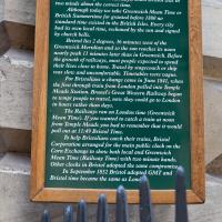
Text Recognition Tags: THE CORN EXCHANGE CLOCK The clock on this building with an extra minute hand recalls early Victorian days, when Bristol was in two minds about the correct time. Although today we take Greenwich Mean Time or British Summertime for granted before 1880 no standard time existed in the British Isles. Every city had its own local time, reckoned by the sun and signed by church bells. Bristol lies 2 degrees, 36 minutes west of the Greenwich Meridian and so the sun reaches its noon nearly peak 11 minutes later than in Greenwich. Before the growth of railways, most people expected to spend their lives close to home. Travel by stagecoach or ship was slow and uncomfortable. Timetables were vague. For Bristolians a change came in June 1841, when the first through train from London pulled into Temple Meads Station. Brunel's Great Western Railway began to tempt people to travel, now they could go to London in hours rather than days. The Railways ran on London time (Greenwich Mean Time). If you wanted to catch a train at noon from Temple Meads you had to remember that it would pull out at 11:49 Bristol Time. To help Bristolians catch their trains, Bristol Corporation arranged for the main public clock on the Corn Exchange to show both local and Greenwich Mean Time (Railway Time) with two minute hands. Other clocks in Bristol adopted the same compromise, In September 1852 Bristol adopted GMT and Bristol time became the same as Lond THE CORN EXCHANGE CLOCK The clock on this building with an extra minute hand recalls early Victorian days , when Bristol was in two minds about the correct time . Although today we take Greenwich Mean Time or British Summertime for granted before 1880 no standard time existed in the British Isles . Every city had its own local time , reckoned by the sun and signed by church bells . Bristol lies 2 degrees , 36 minutes west of the Greenwich Meridian and so the sun reaches its noon nearly peak 11 minutes later than in Greenwich . Before the growth of railways , most people expected to spend their lives close to home . Travel by stagecoach or ship was slow and uncomfortable . Timetables were vague . For Bristolians a change came in June 1841 , when the first through train from London pulled into Temple Meads Station . Brunel's Great Western Railway began to tempt people to travel , now they could go to London in hours rather than days . The Railways ran on London time ( Greenwich Mean Time ) . If you wanted to catch a train at noon from Temple Meads you had to remember that it would pull out at 11:49 Bristol Time . To help Bristolians catch their trains , Bristol Corporation arranged for the main public clock on the Corn Exchange to show both local and Greenwich Mean Time ( Railway Time ) with two minute hands . Other clocks in Bristol adopted the same compromise , In September 1852 Bristol adopted GMT and Bristol time became the same as Lond
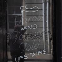
Tarot and fortunes told upstairs.
Tags: Bristol Places UK onemilematt united kingdom City Centre old city The Raven cocktail bar occult
Auto-Tags: Window Handwriting Font Wood Darkness Chalk Art Glass Flash photography Metal Blackboard Monochrome Signage Monochrome photography Advertising
Text Recognition Tags: AND Forum Fold UPSTAIRS AND Forum Fold UPSTAIRS
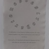
This was the poster on the A-board at the head of the alley that leads to the Centrespace Gallery, and is usually worth a look. It wasn't particularly eyecatching, though, with an A4 poster rather lost in the middle of the much larger board...
Tags: Bristol Places UK onemilematt united kingdom City Centre old city gallery Centrespace destroyertones
Auto-Tags: Font Circle Paper Paper product Pattern Document Event Handwriting Art Graphics Number
Text Recognition Tags: @ 4 "A solitudinal; a head cloud of starlings murmur the songs cloaked amplifiers sing, blissed and burned, in this sidechain ouroboros Immortal fire of individual will, farmed to flaming with love, unheeding the storm-blasts will walk together." @ 4 " A solitudinal ; a head cloud of starlings murmur the songs cloaked amplifiers sing , blissed and burned , in this sidechain ouroboros Immortal fire of individual will , farmed to flaming with love , unheeding the storm - blasts will walk together . "
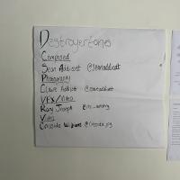
This was rather more a "memo to self" so I'd be able to find the album (for this exhibition was intrinsically linked with Sean Addicott's music) on Spotify.
Tags: Bristol Places UK onemilematt united kingdom City Centre old city gallery Centrespace destroyertones
Auto-Tags: Handwriting Rectangle Font Parallel Writing Paper Paper product Number Document Ink Letter
Text Recognition Tags: Destroyertones Composed Sean Addicott @Seanaddicat Photography Claire Addicott @care add cott VFX/Video Rory Joseph Cro.-artistry Video Cressida Williams @Cressida.jpg E 2 www. Destroyertones Composed Sean Addicott @Seanaddicat Photography Claire Addicott @care add cott VFX / Video Rory Joseph Cro . - artistry Video Cressida Williams @ Cressida.jpg E 2 www .
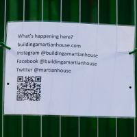
According to the website this is "a research site and artwork to help us think about the future" by Ella Good & Nicki Kent. I'll be interested to go back for another look...
Tags: Bristol Places UK onemilematt united kingdom art The Martian House m-shed
Auto-Tags: Font Rectangle Grass Tree Parallel Pattern Terrestrial plant Plant Mesh Signage Net Number Wood Circle
Text Recognition Tags: What's happening here? buildingamartianhouse.com Instagram @buildingamartianhouse Facebook @buildingamartianhouse Twitter @martianhouse What's happening here ? buildingamartianhouse.com Instagram @buildingamartianhouse Facebook @buildingamartianhouse Twitter @martianhouse

This was on the gate of the rather nice garden at the end of Frayne Road, near the toll house.
Tags: Bristol Places UK onemilematt united kingdom Bedminster North Street sign bicycle
Auto-Tags: Natural landscape Wood Biome Terrestrial plant Grass Trunk Groundcover Landscape Font Forest Plant Signage Sign Poster Woodland
Text Recognition Tags: A decent bicycle was dumped in my garden last weekend. Enquire within if it might be yours A decent bicycle was dumped in my garden last weekend . Enquire within if it might be yours

I'd seen from maybepaints feed that they'd popped a couple of new faces up on the Ashton Avenue bridge. Here's the first...
Tags: Bristol Places UK onemilematt united kingdom Ashton graffiti Ashton Avenue Bridge street art Bridge maybepaints
Auto-Tags: Purple Yellow Font Motor vehicle Art Wood Gas Vehicle door Automotive tire Technology Magenta Audio equipment Signage Metal Graffiti
Text Recognition Tags: Evacuation St mgency e Only Te Evacuation St mgency e Only Te
I'm in the habit of going over to the Tobacco Factory Market on a Sunday. I think I've walked all the routes around that way, but as a Plimsoll Bridge swing let me cross the road to the far side of Brunel Way on my return journey and I took a couple of photos of the brownfield development at the old Ashton Gate Depot site I thought I'd call it a Wander and pop some photos up.

We start the day wandering around the periphery of the Cumberland Basin flyover system. Across Entrance Lock and then around the edge of Spike Island is my preferred route to get to Asthon Avenue Bridge and cross the river.
Present Tense, by Felix "FLX" Braun.
Tags: Bristol Places UK onemilematt united kingdom graffiti street art Southville FLX Felix Braun bank natwest
Auto-Tags: Sky Window Building Cloud Tree Neighbourhood Art Wall Facade City Graffiti Mural Font Leisure Mixed-use
Text Recognition Tags: FLX ELL BEE FLX ELL BEE

El Rincon is a long-established Spanish cafe/bar on North Street. The BAR sign always reminds me of the quirky typefaces used in things like The Pink Panther.

Broody piece from Andrew Burns Colwill on the Greville Smyth Park buildings.
Nipping Up the Zig Zag to the Shops
19 Aug 2023
It's been a long while since I did one of these walks.
I'm thinking of finishing up the project by walking one or two last bits of road, thus being able to declare with all honesty that I've done my best to walk every public road within my mile (and quite a few alleyways besides.) As a prelude, and just because I felt like it, I decided to drag out the camera and GPS on this little wander to the local shops.

Also looking nice and fresh since my last wander is the pair of community noticeboards, with a plethora of local news.
I found out recently that I was a winnner of one of the Hotwells & Cliftonwood Community Association 500 club prizes, which, alongside my membership, is a fun way to give money to the local organisation that puts up these noticeboards and does so much else for the community.
Tags: Bristol Places UK onemilematt united kingdom Clifton Village Hotwells Clifton
Auto-Tags: Poster Font Advertising Picture frame Signage Display board Event Wood Facade Publication Transport Landscape Banner Art
Text Recognition Tags: Howells and Cliftonwood Community Association (ACCA) community cond Useful local information Cond Local Pang Vefa Avon and R Ay GTA abyQMalaw De Oy He PO De 30 G F PAD Lesson for t FRA Obag w BATANGA to your whatapang Var JOE MICKS GUITAR TEACHER BUTHORE.COM y Gramgenee07504 ty PO Box 200 Online Coaching and 61100 TW utrition Quidance Fra ersonal Training sessions LONDRE om prope tech y and get aang d 222000 Get Fit, Be Healthier, Be The Best Version Of You! www.top be and reach SOF ing out to Our sto Quran We have ww Facebook Tutir @COtt G35 Top for my on or stop you A O 07564375433 @w tabourside and Satu Action Fraud ALERT AF Google .***. of St DAS y Th y AudionFraud SA 13304 W 15. Ch Lifeskitts LEARNING FOR LIVING Guing which includes working wilt amal and active safatyti Wysan bes the fe WELCOME SPACE at CLIFTON LIBRARY activitating January 2635 (10 ng WELCOME SPACE We are currently looking for people to help us deliver safety education to children via our enginteractive village based in central Bristol www50 Hotwells & Cliftonwood Community Association 500 CLUB RESULTS 2023 1 mn m Hot drinks Relax GAMES CRAFTING Films CHAT Wellbeing Newspapers Study KAPHY TABLE TENNIS Hasting which includes opening and sing talk with the c sporting teachers re The 100 Challe Join us for a tester heut Wednesday 12th April is the next scheduled taster hour please contact the email below for more information and to book your place OLLYW4 Hvat e ang pag Apt Now swight Robert C con Nowhe CIP ad NC Nowe Man No for 2 yr y dece ww OXO AUTY New THANK YOU TO ALL OF THE YOUR 300C SUCTIONS A HANG POSLE POES THAT HELPO THE LOCALE EVERY MONTH WE HAVE UNCLAIMED PRIZE HONEY THAT COULD YOUR CLUB FOR THE CHANCE TO BE YOU NAM NAD OF NO WINNER OWN AND SUPPORT THE WORK OF YOUR LOCAL COMMUNITY SCAN ME bile PR COURE Ap C Te qu 700 Emetas T Com You to t You fost d Shpaloaph we would love to make oef regularly vegade ba ne Beinart Art & Art haling p A you missing making an DEMENTIA SAFEGUARDING SCHEMEL www.beinartotive.c 4 Ben sad fin BEWARE PROSITY Criminals are adapting! there are many where you ca weket M -Tudo que fa thoshwade - pada poleg oniks and li MA ART whick - server creaty PCRIME and the deving the vers If you're not sure, research more! www Having a baby? - PRACTICAL and EMOTIONAL support is available for you in the cala in pomancy, birth and pomnically Sear Roma Helen Whit ANME PROCITY O Howells and Cliftonwood Community Association ( ACCA ) community cond Useful local information Cond Local Pang Vefa Avon and R Ay GTA abyQMalaw De Oy He PO De 30 G F PAD Lesson for t FRA Obag w BATANGA to your whatapang Var JOE MICKS GUITAR TEACHER BUTHORE.COM y Gramgenee07504 ty PO Box 200 Online Coaching and 61100 TW utrition Quidance Fra ersonal Training sessions LONDRE om prope tech y and get aang d 222000 Get Fit , Be Healthier , Be The Best Version Of You ! www.top be and reach SOF ing out to Our sto Quran We have ww Facebook Tutir @COtt G35 Top for my on or stop you A O 07564375433 @w tabourside and Satu Action Fraud ALERT AF Google . *** . of St DAS y Th y AudionFraud SA 13304 W 15. Ch Lifeskitts LEARNING FOR LIVING Guing which includes working wilt amal and active safatyti Wysan bes the fe WELCOME SPACE at CLIFTON LIBRARY activitating January 2635 ( 10 ng WELCOME SPACE We are currently looking for people to help us deliver safety education to children via our enginteractive village based in central Bristol www50 Hotwells & Cliftonwood Community Association 500 CLUB RESULTS 2023 1 mn m Hot drinks Relax GAMES CRAFTING Films CHAT Wellbeing Newspapers Study KAPHY TABLE TENNIS Hasting which includes opening and sing talk with the c sporting teachers re The 100 Challe Join us for a tester heut Wednesday 12th April is the next scheduled taster hour please contact the email below for more information and to book your place OLLYW4 Hvat e ang pag Apt Now swight Robert C con Nowhe CIP ad NC Nowe Man No for 2 yr y dece ww OXO AUTY New THANK YOU TO ALL OF THE YOUR 300C SUCTIONS A HANG POSLE POES THAT HELPO THE LOCALE EVERY MONTH WE HAVE UNCLAIMED PRIZE HONEY THAT COULD YOUR CLUB FOR THE CHANCE TO BE YOU NAM NAD OF NO WINNER OWN AND SUPPORT THE WORK OF YOUR LOCAL COMMUNITY SCAN ME bile PR COURE Ap C Te qu 700 Emetas T Com You to t You fost d Shpaloaph we would love to make oef regularly vegade ba ne Beinart Art & Art haling p A you missing making an DEMENTIA SAFEGUARDING SCHEMEL www.beinartotive.c 4 Ben sad fin BEWARE PROSITY Criminals are adapting ! there are many where you ca weket M -Tudo que fa thoshwade - pada poleg oniks and li MA ART whick - server creaty PCRIME and the deving the vers If you're not sure , research more ! www Having a baby ? - PRACTICAL and EMOTIONAL support is available for you in the cala in pomancy , birth and pomnically Sear Roma Helen Whit ANME PROCITY O
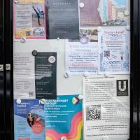
More notices, including a couple of newcomers to the local businesses: Hopewell, an estate agency, has opened up just down Hopechapel Hill in the place of The Landmark Practice (an environmental consultancy firm that seem to have moved out to Long Ashton) and HappyBack, who I'd noticed appearing down on the Hotwell Road a month or two ago.
Tags: Bristol Places UK onemilematt united kingdom Clifton Village Hotwells Clifton
Auto-Tags: Poster Font Gas Signage Advertising Facade Display board Billboard Town City Machine Transport
Text Recognition Tags: SAVE JACOBS WELLS your We W ty WS Na à Order w a gratyf Lauan ya wld worldcat HERE THE PETI Cale wwwwww CHBUEC C www d Dabe 17 TANTO F www. 0-100 Your journey is our journey and we are here to help you every step of the way Wend fpwith vir Ourica apteert papper mating nything t neces or Sc ng vs Shack and petere p FM 2 yan unteers Needed 0/0 70-23 DAN HappyBack Find Ho D Highly experienced Physiotherapy. Osteopathy and H® Massage specialists, helping you to get your happy back! W Lifeskills Lifeskills Learning for Living Py Acad Marg back. people to join our amazing toomer volunteers Oxime ww We are your new neighbours! pelare a prsity independent state aguny tinging together every best o ort, medium Alongtam ss and mes for sale across the city ravis A NEW Ma # HOPEWELL Come and say hello at our new offic orated at Hope Chcel House Hone Chapel Hill BSB IND 0117 911 8663 CERED ww are acest (10-only) og for new SANT FREE PEER SUPPORT GROUP TUESDAYS ONLINE 6.30-8.30pm 24ury Facilitated by LGBTQIA people Safe, nonjudgemental, confidential space to discuss mental wellbeing with other LGSTOLA+people Trinity Lunch Club Thursdays 10am-3:30pm Morning Coffee Armchair Excises 3 Course Home Cooked Lunch CET ARTIN Quiz Activities Tea & Biscuits For more information Call 07458 300 210 or email tes@holytrinityhotwells.org Holy Trinity Church serving the communities of Hotwells, Cliftonwood, Saike Island, Harboursie holytrinityhotwells.org Alexander May Having a baby? 42- AU You and your birth partner weinstela Calm Births Hypnobirthing FREE TASTER SESSION, online with Dolanan Monday th September OXO 7.30pm P By placeb www.dealbws.com We are devastated by the fire at the Underfall Yard. fre The fee has destroyed the heart of the Yard where most of the boat building activity takes place and tenant's businesses and boats have. been ruined. Thankfully no one was killed and no on was injured, but a lot of people in the Underfall Yard community have been impacted our staff, our tenants, our volunteers and our neighbours on Avon Crescent and Nova Scotia Place. Our hearts are with them and we are supporting our tenants as best we can. P DARO l HIER UNDERFALL YARD TRUST The Underfall Yard Trust was formed i the 1990's to bring the Underfall Yard out of dereliction, to look after the historio buildings, to shine a light on Bristoll's engineering harbour heritage and to promote traditional marine skills. In light of the devastation at the Yard, those aims remain as relevant now as they were then, SE We absolutely are committed to rebuilding the Underfall Yard and continuing the charity's work, If you would like to support the Trust, please see our JustGiving page, scan the QR code or alternatively, there is a donation box located on the Café till. https://www.justgiving.com/theunderfallyardtrust SAVE JACOBS WELLS your We W ty WS Na à Order w a gratyf Lauan ya wld worldcat HERE THE PETI Cale wwwwww CHBUEC C www d Dabe 17 TANTO F www . 0-100 Your journey is our journey and we are here to help you every step of the way Wend fpwith vir Ourica apteert papper mating nything t neces or Sc ng vs Shack and petere p FM 2 yan unteers Needed 0/0 70-23 DAN HappyBack Find Ho D Highly experienced Physiotherapy . Osteopathy and H® Massage specialists , helping you to get your happy back ! W Lifeskills Lifeskills Learning for Living Py Acad Marg back . people to join our amazing toomer volunteers Oxime ww We are your new neighbours ! pelare a prsity independent state aguny tinging together every best o ort , medium Alongtam ss and mes for sale across the city ravis A NEW Ma # HOPEWELL Come and say hello at our new offic orated at Hope Chcel House Hone Chapel Hill BSB IND 0117 911 8663 CERED ww are acest ( 10 - only ) og for new SANT FREE PEER SUPPORT GROUP TUESDAYS ONLINE 6.30-8.30pm 24ury Facilitated by LGBTQIA people Safe , nonjudgemental , confidential space to discuss mental wellbeing with other LGSTOLA + people Trinity Lunch Club Thursdays 10 am-3:30pm Morning Coffee Armchair Excises 3 Course Home Cooked Lunch CET ARTIN Quiz Activities Tea & Biscuits For more information Call 07458 300 210 or email tes@holytrinityhotwells.org Holy Trinity Church serving the communities of Hotwells , Cliftonwood , Saike Island , Harboursie holytrinityhotwells.org Alexander May Having a baby ? 42 AU You and your birth partner weinstela Calm Births Hypnobirthing FREE TASTER SESSION , online with Dolanan Monday th September OXO 7.30pm P By placeb www.dealbws.com We are devastated by the fire at the Underfall Yard . fre The fee has destroyed the heart of the Yard where most of the boat building activity takes place and tenant's businesses and boats have . been ruined . Thankfully no one was killed and no on was injured , but a lot of people in the Underfall Yard community have been impacted our staff , our tenants , our volunteers and our neighbours on Avon Crescent and Nova Scotia Place . Our hearts are with them and we are supporting our tenants as best we can . P DARO l HIER UNDERFALL YARD TRUST The Underfall Yard Trust was formed i the 1990's to bring the Underfall Yard out of dereliction , to look after the historio buildings , to shine a light on Bristoll's engineering harbour heritage and to promote traditional marine skills . In light of the devastation at the Yard , those aims remain as relevant now as they were then , SE We absolutely are committed to rebuilding the Underfall Yard and continuing the charity's work , If you would like to support the Trust , please see our JustGiving page , scan the QR code or alternatively , there is a donation box located on the Café till . https://www.justgiving.com/theunderfallyardtrust
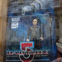
A random reminder of a TV show of my youth: Londo Mollari, the Centauri Ambassador to Babylon 5. Spotted in the window of the Oxfam shop on Victoria Street after I grabbed a coffee from Foliage Cafe.
Tags: Bristol Places UK onemilematt united kingdom Clifton Village Clifton Babylon 5 Cantauri Londo Mollari Oxfam charity shop
Auto-Tags: Art Graffiti Font Facade Building City Window Mural Street Advertising Visual arts Glass Street art Graphics Painting
Text Recognition Tags: FEFE AMBASSADOR FIN Londo Mollari with Transport- of Centauri Republic. 20 70094361 2820 1997 FiGta IN POX. 714.99 W30 EARTH ALLIANCE ASST 20017 NO, 20016 BABYLON PREMIERE AGES 4 AND UP SPACE STATION FEFE AMBASSADOR FIN Londo Mollari with Transport of Centauri Republic . 20 70094361 2820 1997 FiGta IN POX . 714.99 W30 EARTH ALLIANCE ASST 20017 NO , 20016 BABYLON PREMIERE AGES 4 AND UP SPACE STATION