Tagged: bedrock
Museum of the Moon, and a Bit of Redland
21 Aug 2021
Lisa and I mostly went out to have a look at Luke Jerram's Museum of the Moon as its tour hit Bristol Cathedral—I missed it when it was previously in town, at Wills Hall, I think—but we also took a trek up to Redland. Lisa's kind enough to indulge my strange current fascination with the Edwardian eccentrics that made up the Stella Matutina, so we swung by a couple of places with a vague connection to the Bristol branch of the organisation. Well, it was good walking, anyway...
As a stunning bonus, one of the picture's descriptions has more information than you'd probably want on the Bristol Port Railway and Pier's Clifton Extension Railway line, but I did happen to coincidentally write up this wander after reading about the extension line during my lunch hour at work today. It's a thrilling life, I tell you...
More from ChurchDB:
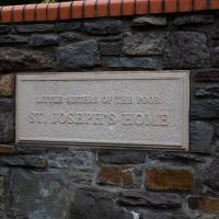
"The order was founded by St Jeanne Jugan, after she rescued two poverty-stricken elderly women from the streets of Paris during the French Revolution. The Sisters' work continues today, in providing care for the elderly - for an account of this, see the article Celebrating the Little Sisters with big hearts published in the Bristol Post on 15th October 2012, reporting on the celebration of 150 years of their work."
And even more on Wikipedia, of course...
Mostly the Metal Animals of a Clifton Garden
30 Aug 2021
Lisa and I went for a longish walk, but I didn't take many photos. Mostly we just wandered and nattered. Unusually, my target was outside my 1-mile radius on Burlington Road in Redland, where I snapped quite a few photos of the collection of artistic animals by Julian Warren. This was mostly to provide a fairly arbitrary destination for a roundabout walk in Clifton...
From an Avon Gorge Geology Excursion Guide I dug up:
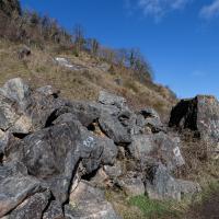
Just south of the Observatory, on the right of the path is a children’s playground [ST 5667 7325] in the remains of a limestone quarry. In the back wall is a bricked-up adit, presumably representing the entrance to a former iron ore or lead mine (Fig. 10C). The roof of the adit is fissured and sparry, crystalline calcite can be seen in fissures.
The playground itself is in one of the the quarries used for the Suspension Bridge materials.
I recently indulged myself by buying a little piece of history. I've mentioned Samuel Loxton and featured and linked to his drawings before, often in the eminently browsable Loxton Collection albums that Bristol Libraries has on Flickr. So when I saw a Loxton drawing of Hotwells pop up on eBay, I decided to get myself a little treat.
I don't think there's any Loxton drawing that features the road I actually live in—it's not very visible from anywhere else, not being one of these Clifton terraces that's perched at the top of a hill, or anything like that, and it's invisible in most views of the area. However, this Loxton drawing, Hotwells, Looking across the river from near the Clifton Bridge station, is probably the closest near-miss I've seen.
I decided to wander out one morning and see if I could reproduce the picture, and also take a photo or two of what's now become of the Clifton Bridge Station, which is still just about discernible in places.
(Then on an even stranger whim I decided to check out a possible little cut-through from Cumberland Road to the harbourside I'd been eyeing up on my commute to work, so walked to Wapping Wharf for a croissant via this potential new route, but that bit's not quite as interesting...)
Site of the Rownham Ferry. Follow the link for a charming Loxton ink drawing on Know Your Place, also viewable at the Bristol Libraries Flickr collection.
This was a later site for the ferry, which earlier was a tad further out along the river. It would have been a key crossing point at this end of Bristol before the arrival of any bridges near here. Before the Ashton Swing Bridge and the Vauxhall footbridge arrived, the next-nearest crossing point would have been the Vauxhall ferry, which was where Vauxhaull Bridge stands now, I think.
I went out simply wanting to knock off the very last little unwalked section of Clanage Road, over by Bower Ashton, which has been annoying me for a while as it's quite close by and I've walked the other bits of it several times. So, my plan was to nip over to Greville Smyth Park via a slightly unusual route to wander Clanage Road and tick it off.
Along the way, though, I inevitably got a bit distracted. I took a few photos of Stork House, a grand Hotwell Road building that's recently been done up a bit (I imagine it's student lets, though I'm not sure) and which I found a reference to in a book about the Port Railway and Pier the other week, and also tried to match up a historical photo of Hotwells before the Cumberland Basin Flyover System laid it waste, which included some interesting markers I'll have to do a bit more digging into...
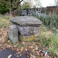
A milestone, perhaps? And there looks to be a benchmark on the bigger bit.
Aha! A quick look at the historic OS maps on Know Your Place finds a marker right on this spot marked "B.S.", which the National Library of Scotland's helpful abbreviations page translates as "Boundary Stone". With that in mind I then had a look on the wonderful geograph site and there it is:
The front stone appears to be an old boundary stone, delineating the Administrative County, Parliamentary County and Rural District boundaries that were part of the Bristol limits in the twentieth century, possibly dated 1897? Behind it is a larger block of stones that may have been part of the Smyth estate further up the hill. On the latter is a partly hidden benchmark.
So I spotted the partly hidden benchmark correctly, too :) There is, of course, a benchmarks directory with an entry for the benchmark itself. What did people do before the internet?
EDIT TO ADD Nearly a year later, I watching a DVD Bristol Railway Stations by Mike Oakley and found out what the larger bit behind the milestone actually is: it's the last remnant of the Clifton Bridge Station buildings, which once faced out onto the road here.
The more I research it, the more I find that Hotwells had far better transport links back in Victorian and Edwardian times than it has today. Along with buses that went to more useful places than the City Centre, there were trams, the funicular up to Clifton, the landing stage for paddle steamer services and two railway stations all within easy walking distance of me.
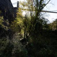
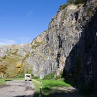
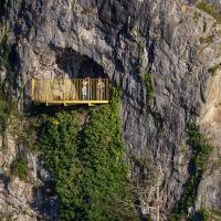
Today I took a day off work as preparation for doing the bookkeeping for my tax return1, and took a wander along to the site of what would have been my nearest station, Hotwells (or Clifton, as it started out in life), nestled in the shadow of the suspension bridge, the Bristol terminus of the Bristol Port Railway and Pier.
From there I wandered down the Portway, following the original line, until I got to the area around Sneyd Park Junction, where the tunnel from the slightly later Clifton Extension Railway joined up with this originally-isolated BPR line. Then I headed up to Clifton through the "goat gully" at Walcombe Slade, seeing the few above-ground bits of evidence of the tunnel (which is still in regular use) along the way.
It was a lovely day, and a good walk, and it was interesting to daydream of the times when I could have walked a few minutes from my flat down to Dowry Parade, caught a short tram ride to Hotwells Stations, and then headed from there to Avonmouth, perhaps even to board a transatlantic passenger service. The completion of the Clifton Extension Railway that linked the Avonmouth station with Temple Meads made relatively direct transatlantic travel from London via Bristol possible, with passengers travelling up from Paddington to Temple Meads, on to Avonmouth on the Clifton Extension Railway and Port Railway and Pier line, then perhaps catching a Cambpell's paddle steamer—which sometimes acted as tenders for large steamers—to a larger ship that was headed out for Canada, say.
1 I've learned that the best approach is to take two days off and deliberately do something that's not my bookkeeping on the first day, as otherwise I just inevitably end up procrastinating and feeling guilty on the first day no matter what. I have an odd brain, but at least I'm learning strategies for dealing with its strange ways as I get older...
2 Information mostly gleaned from Colin Maggs' The Bristol Port Railway & Pier and the Clifton Extension Railway, The Oakwood Press, 1975.
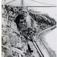
This photo comes from the M Oakley Collection via a scan from Branch Lines Around Avonmouth, by Vic Mitchell and Keith Smith, ISBN 190447442X. My reproduction quality isn't great, but hopefully you can see Hotwells Station as it was in its early years, including the turntable at the far end, just in front of the stationmaster's house, to the left of the booking office.
Later the turntable was removed and the tracks extended all the way to the end to make the most of the limited platform space; the engine would move onto the centre run-around track in advance, then pull the carriages into the station on the other track using a draw-bar instead of using the turntable to run around them after it had pulled them in.
My favourite tidbit from Colin Maggs' The Bristol Port Railway & Pier is the last bit here:
Around the turn of the century, a stationmaster at Sea Mills kept poultry, pigs, a cow and used his pony and trap to fetch swill from the docks. He sold eggs to passengers and provided the the Superintendent at Bristol with butter and new-laid eggs. Another character was a driver nicknamed ‘Mad Jack’. He enjoyed scaring the dockers to death by rushing through the tunnels into Hotwells, once misjudging his braking power and crashing into the buffers.
Must've been quite unnerving, racing out of the tunnel straight towards the cliff face at speed!
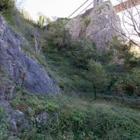
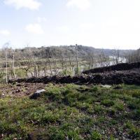
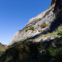
It's so overgrown today you can't even tell if the shape of the landscape from the postcard is still in place.
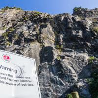
This is known for being something of a fragile area. Here's a picture of the earlier dangerous face being blasted away in the summer of '76, to stop it falling on the Portway. Every year the Portway is closed for a day or two to allow for a close inspection that can lead to the planning of remedial works. I'll often get a bit of notice of this, as they have to put the warning signs up quite early down in Hotwells so people can plan their alternative routes.
If it weren't for the gert big road next to it, this would be a lovely place to spend some time.
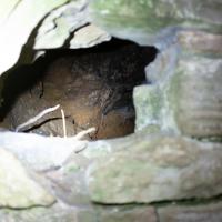
Of course there's graffiti in there. This was, apparently, used as a stable!
Further to improve the ventilation provided by the two vertical shafts, in 1950 an old shaft leading out to the face of the gorge was re-opened after having been blocked for many years. Originally it had been used as a stable for ponies employed in tunnel construction. A ganger's cabin is hewn out of the side of the tunnel and is on the down side approximately midway.
— Colin Maggs, The Bristol Port Railway & Pier and the Clifton Extension Railway, The Oakwood Press, 1975
From To Keep Open and Unenclosed, the Management of the Durdham Down Since 1861, Bristol Branch of the Historical Association, 2005:
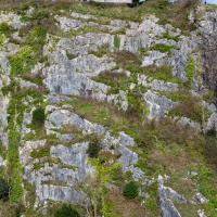
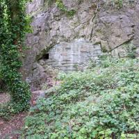
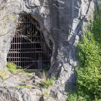
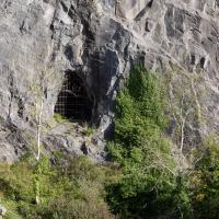
On the Avonmouth side of the Pembroke Road shaft two further shafts were made (one vertical to a ventilation turret in the Gulley and the other horizontal to an opening in the face of the Black Rock Quarry.
So, bearing in mind that this is Black Rock Quarry, I'd say there's a good chance this is the third, and least photogenic, ventilation shaft for the Clifton Extension Railway Tunnel. Later on in this wander we'll see the other two, which are rather prettier.
Bower Ashton is an interesting little area just south of the river from me—in fact, the Rownham Ferry used to take people over from Hotwells to Bower Ashton, operating from at least the twelfth century to around the 1930s.
It's a strangely contradictory little area, with a cluster of old and new houses sandwiched in between the busy A-roads and significantly more industrial area of Ashton and the bucolic country estate of Ashton court roughly east to west, and also between Somerset and Bristol, north to south.
I've been around here before, mostly poking around Bower Ashton's arguably most well-known bit, the Arts faculty campus of the University of the West of England, but I'd missed at least Parklands Road and Blackmoors Lane, so I initially planned just to nip across briefly and wander down each in turn. On a whim, though, I texted my friends Sarah and Vik in case they were out and about, and ended up diverting to the Tobacco Factory Sunday market first, to grab a quick flat white with them, extending my journey a fair bit.
To start with, though, I nipped to a much more local destination, to see something that you can't actually see at all, the Gridiron...
(I also used this wander as a test of the cameras in my new phone. I finally upgraded after a few years, and the new one has extra, separate wide and telephoto lenses compared to the paltry single lens on my old phone. Gawd. I remember when speed-dial was the latest innovation in phones...)
The Gridiron and Bower Ashton Part Two
03 Dec 2021
On my last wander, to Bower Ashton, I was intending to knock Blackmoors Lane off my list "to-do" list, but got a bit diverted. I also took a little look into the history of the Gridiron, once a cheaper alternative to dry dock that was nestled just south of North Entrance Lock.
Today I had to go to send a parcel off somewhere, so I decided on going to the North Street Post Office via Blackmoors Lane. I didn't have much intention of anything else, but as luck would have it I walked out both at low tide and also as some lockkeepers seemed to be having a bit of a training session, and one of the more senior people was (a) happy to answer a few random questions on the Gridiron and (b) actually knew a lot about it, as Gridiron maintenance had been one of his jobs, more than twenty years ago...
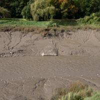
So, this is all that can be seen today of a 200-foot long, 38-foot wide grid of wood, I think—at first I figured it was metal, but Nick Howes posted a historic photo on Twitter where the grid itself certainly looks to be made of timber—hidden completely by a simple build-up of silt.
Up until the year 2000, it had been in use since some time in the 1890s, I think. Grace's guide's copy of the Institution of Civil Engineer's obituary of John McCurrich certainly attributes the construction of a gridiron to him while he was Docks Engineer for Bristol, and he held that post from 1890 until his death in 1899.
Lunchtime Reproduction (of an old photo...)
17 Jan 2022
This was basically the quick lunchtime jaunt I tried to do at the beginning of January, only this time I actually managed to get to roughly the viewpoint I'd been hoping for to recreate a historical photo of the Bristol International Exhibition.
I did this walk about a month ago, but I've been a bit poorly and not really up to doing much in my spare time, and it's taken me this long to even face processing even these few photos. Hopefully normal service will be resumed at some point and I can carry on trying to walk any roads and paths that I need to do to make this project feel complete...
There's a couple on the balcony taking a selfie in this direction. I wonder if I've been immortalised as a few pixels in the background of their photo...
Bedminster Trip for New Walking Shoes
26 Feb 2022
I needed to buy new walking shoes—my old ones were squeaking and it was driving me up the wall—so I ordered some for collection from Taunton Leisure on East Street in Bedminster, and decided to make picking them up an official wander.
I didn't cover any new ground within my mile, but I did take advantage of the trip to take in a few interesting things just outside my normal radius, mostly New Gaol-related. Along the way there are a couple of sanitation-related diversions, including a visit to a rare manhole cover. You can hardly wait, I can tell!
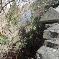
Well, it slopes down to the riverside at the top of the slipway. I presume there are still steps under there.
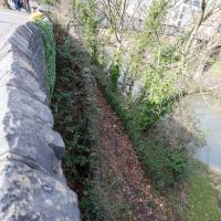
Leaning over the wall, we can see the overgrown steps from the bricked up gate leading down to the start of the ramp down to the ferry crossing.
Leigh Woods Purple Path
12 Mar 2022
There's a few tracks in Leigh Woods that lie within my mile and show up on my map but that I've not walked yet, so I decided to take one of my traditional big long walks through the woods on this nice crisp sunny morning.
For years—decades, even—I've been doing a similar route from my place, along the towpath to the far woods entrance, up the hill for a varied walk on one of the marked tracks and then across the Suspension Bridge to Clifton Village for a coffee-based reward. It's my default "long walk", really, and I almost always enjoy it. Today, at last, spring actually seemed to be springing, which made for some extra positivity...