Tagged: uk
I'm in the habit of going over to the Tobacco Factory Market on a Sunday. I think I've walked all the routes around that way, but as a Plimsoll Bridge swing let me cross the road to the far side of Brunel Way on my return journey and I took a couple of photos of the brownfield development at the old Ashton Gate Depot site I thought I'd call it a Wander and pop some photos up.

"STEEP DROP INTO MUD AND FAST FLOWING WATER".
This sign has been mildly annoying photographers since it was put up, getting a bit in the way of several alternative views from this bit of land. I presume it was installed in response to some kind of accident, but I'd hazard a guess that whatever difficulties someone got into probably wouldn't have been prevented by a sign that stated the completely bloody obvious.
Tags: Bristol Places UK onemilematt united kingdom Hotwells graffiti Avon Gorge river avon Spike Island
Auto-Tags: Water Sky Water resources Plant Cloud Tree Watercourse Bank Natural landscape Road Lake Leisure Morning Summer Landscape
Text Recognition Tags: NEX 1997 Zit NEX 1997 Zit

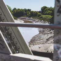
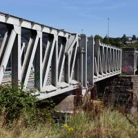
We start the day wandering around the periphery of the Cumberland Basin flyover system. Across Entrance Lock and then around the edge of Spike Island is my preferred route to get to Asthon Avenue Bridge and cross the river.

I've recently been playing the computer game Life Is Strange, and it's inspired me to get a bit more snappy. The heroine is a photography student, and part of the game is to go around snapping artistic pics with her Polaroid camera. I don't have a polaroid, but the game did inspire me to stick the simple 50mm prime lens on the camera and to trust my instincts on things to snap. This was probably the best result of the day.
Tags: Bristol Places UK onemilematt united kingdom Bedminster Ashton Ashton Avenue Bridge river avon avon new cut Spike Island Bridge
Auto-Tags: Water Water resources Sky Daytime Body of water Tree Bridge Morning Waterway Wood Landscape Grass Metal Nonbuilding structure Reflection
Text Recognition Tags:
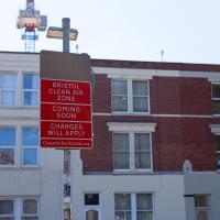
The Clean Air Zone is being introduced later this year (currently they say 28 November 2022, but I think it's already been delayed twice.)
The scheme will see charges instituted for certain vehicles entering parts of the city, especially older diesel cars. This is to encourage people to change these older cars or find alternative routes or modes of transport. Apparently there are grants and loans available for upgrades on offer to private citizens and businesses.
This should only have positive effects for me, as I live just inside the zone, and I drive a recentish petrol car with an efficient and not-so-pollutey engine. In a perfect world, therefore, this scheme means my area might eventually start meeting the government's standards for air quality. This Bristol 24/7 article has some good info, including an estimate that there are currently 300 premature deaths per year from traffic-related air pollution in the proposed Bristol zone.
Tags: Bristol Places UK onemilematt united kingdom North Street Ashton Southville CAZ Clean Air Zone
Auto-Tags: Sky Window Building Fixture House Facade City Roof Commercial building Mixed-use Signage Apartment Brick Sash window Advertising
Text Recognition Tags: BRISTOL CLEAN AIR ZONE COMING SOON CHARGES WILL APPLY CleanAirFor Bristol.org BRISTOL CLEAN AIR ZONE COMING SOON CHARGES WILL APPLY CleanAirFor Bristol.org

The street art is still looking good, but one of these properties has been turned into such low-end multiple-occupancy accommodation that it got into the Bristol Post this week with pictures of one tiny room with a shower alongside the bed serving as the sole room per person, with a toilet shared between four "studio rooms". I suppose this is actually better than the student accommodation I had in my first year at Warwick, but at least that was actually on campus...
Tags: Bristol Places UK onemilematt united kingdom Bedminster North Street Southville
Auto-Tags: Sky Building Window Car Wheel Vehicle Architecture Street light Neighbourhood House Urban design Residential area Commercial building Real estate Facade
Text Recognition Tags: PAS AN ENNAST SANAT PELTI SECOLT UNHA LOUR FOR SALE PAS AN ENNAST SANAT PELTI SECOLT UNHA LOUR FOR SALE

Present Tense, by Felix "FLX" Braun.
Tags: Bristol Places UK onemilematt united kingdom graffiti street art Southville FLX Felix Braun bank natwest
Auto-Tags: Sky Window Building Cloud Tree Neighbourhood Art Wall Facade City Graffiti Mural Font Leisure Mixed-use
Text Recognition Tags: FLX ELL BEE FLX ELL BEE
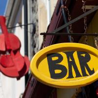
El Rincon is a long-established Spanish cafe/bar on North Street. The BAR sign always reminds me of the quirky typefaces used in things like The Pink Panther.

Veg from the Tobacco Factory farm shop in my Idler tote and a market croissant to go with my Coffee #1 iced latte, I feel only the need to sit on a bench and read a Saul Bellow novel to fully sink into my Southville hipster character. I should probably have ridden a penny farthing here and bought some chia seeds.
Tags: Bristol Places UK onemilematt united kingdom Greville Smyth Park bench Southville reading The Idler Herzog Saul Bellow
Auto-Tags: Food Tableware Textile Tree Table Plate Sky Drinkware Leisure Cup Motor vehicle Serveware Grass Recreation Event
Text Recognition Tags: GEBBROW Herzog DLER GEBBROW Herzog DLER
Nipping Up the Zig Zag to the Shops
19 Aug 2023
It's been a long while since I did one of these walks.
I'm thinking of finishing up the project by walking one or two last bits of road, thus being able to declare with all honesty that I've done my best to walk every public road within my mile (and quite a few alleyways besides.) As a prelude, and just because I felt like it, I decided to drag out the camera and GPS on this little wander to the local shops.
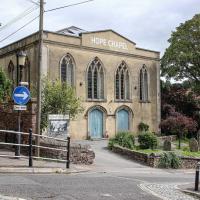
I may not personally be a fan of evangelical Christianity, but at least they keep the place looking nice. It's still very tidy since the recent renovation, installaltion of solar panels on the roof and repainting of the HOPE CHAPEL sign.
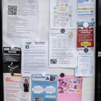
Also looking nice and fresh since my last wander is the pair of community noticeboards, with a plethora of local news.
I found out recently that I was a winnner of one of the Hotwells & Cliftonwood Community Association 500 club prizes, which, alongside my membership, is a fun way to give money to the local organisation that puts up these noticeboards and does so much else for the community.
Tags: Bristol Places UK onemilematt united kingdom Clifton Village Hotwells Clifton
Auto-Tags: Poster Font Advertising Picture frame Signage Display board Event Wood Facade Publication Transport Landscape Banner Art
Text Recognition Tags: Howells and Cliftonwood Community Association (ACCA) community cond Useful local information Cond Local Pang Vefa Avon and R Ay GTA abyQMalaw De Oy He PO De 30 G F PAD Lesson for t FRA Obag w BATANGA to your whatapang Var JOE MICKS GUITAR TEACHER BUTHORE.COM y Gramgenee07504 ty PO Box 200 Online Coaching and 61100 TW utrition Quidance Fra ersonal Training sessions LONDRE om prope tech y and get aang d 222000 Get Fit, Be Healthier, Be The Best Version Of You! www.top be and reach SOF ing out to Our sto Quran We have ww Facebook Tutir @COtt G35 Top for my on or stop you A O 07564375433 @w tabourside and Satu Action Fraud ALERT AF Google .***. of St DAS y Th y AudionFraud SA 13304 W 15. Ch Lifeskitts LEARNING FOR LIVING Guing which includes working wilt amal and active safatyti Wysan bes the fe WELCOME SPACE at CLIFTON LIBRARY activitating January 2635 (10 ng WELCOME SPACE We are currently looking for people to help us deliver safety education to children via our enginteractive village based in central Bristol www50 Hotwells & Cliftonwood Community Association 500 CLUB RESULTS 2023 1 mn m Hot drinks Relax GAMES CRAFTING Films CHAT Wellbeing Newspapers Study KAPHY TABLE TENNIS Hasting which includes opening and sing talk with the c sporting teachers re The 100 Challe Join us for a tester heut Wednesday 12th April is the next scheduled taster hour please contact the email below for more information and to book your place OLLYW4 Hvat e ang pag Apt Now swight Robert C con Nowhe CIP ad NC Nowe Man No for 2 yr y dece ww OXO AUTY New THANK YOU TO ALL OF THE YOUR 300C SUCTIONS A HANG POSLE POES THAT HELPO THE LOCALE EVERY MONTH WE HAVE UNCLAIMED PRIZE HONEY THAT COULD YOUR CLUB FOR THE CHANCE TO BE YOU NAM NAD OF NO WINNER OWN AND SUPPORT THE WORK OF YOUR LOCAL COMMUNITY SCAN ME bile PR COURE Ap C Te qu 700 Emetas T Com You to t You fost d Shpaloaph we would love to make oef regularly vegade ba ne Beinart Art & Art haling p A you missing making an DEMENTIA SAFEGUARDING SCHEMEL www.beinartotive.c 4 Ben sad fin BEWARE PROSITY Criminals are adapting! there are many where you ca weket M -Tudo que fa thoshwade - pada poleg oniks and li MA ART whick - server creaty PCRIME and the deving the vers If you're not sure, research more! www Having a baby? - PRACTICAL and EMOTIONAL support is available for you in the cala in pomancy, birth and pomnically Sear Roma Helen Whit ANME PROCITY O Howells and Cliftonwood Community Association ( ACCA ) community cond Useful local information Cond Local Pang Vefa Avon and R Ay GTA abyQMalaw De Oy He PO De 30 G F PAD Lesson for t FRA Obag w BATANGA to your whatapang Var JOE MICKS GUITAR TEACHER BUTHORE.COM y Gramgenee07504 ty PO Box 200 Online Coaching and 61100 TW utrition Quidance Fra ersonal Training sessions LONDRE om prope tech y and get aang d 222000 Get Fit , Be Healthier , Be The Best Version Of You ! www.top be and reach SOF ing out to Our sto Quran We have ww Facebook Tutir @COtt G35 Top for my on or stop you A O 07564375433 @w tabourside and Satu Action Fraud ALERT AF Google . *** . of St DAS y Th y AudionFraud SA 13304 W 15. Ch Lifeskitts LEARNING FOR LIVING Guing which includes working wilt amal and active safatyti Wysan bes the fe WELCOME SPACE at CLIFTON LIBRARY activitating January 2635 ( 10 ng WELCOME SPACE We are currently looking for people to help us deliver safety education to children via our enginteractive village based in central Bristol www50 Hotwells & Cliftonwood Community Association 500 CLUB RESULTS 2023 1 mn m Hot drinks Relax GAMES CRAFTING Films CHAT Wellbeing Newspapers Study KAPHY TABLE TENNIS Hasting which includes opening and sing talk with the c sporting teachers re The 100 Challe Join us for a tester heut Wednesday 12th April is the next scheduled taster hour please contact the email below for more information and to book your place OLLYW4 Hvat e ang pag Apt Now swight Robert C con Nowhe CIP ad NC Nowe Man No for 2 yr y dece ww OXO AUTY New THANK YOU TO ALL OF THE YOUR 300C SUCTIONS A HANG POSLE POES THAT HELPO THE LOCALE EVERY MONTH WE HAVE UNCLAIMED PRIZE HONEY THAT COULD YOUR CLUB FOR THE CHANCE TO BE YOU NAM NAD OF NO WINNER OWN AND SUPPORT THE WORK OF YOUR LOCAL COMMUNITY SCAN ME bile PR COURE Ap C Te qu 700 Emetas T Com You to t You fost d Shpaloaph we would love to make oef regularly vegade ba ne Beinart Art & Art haling p A you missing making an DEMENTIA SAFEGUARDING SCHEMEL www.beinartotive.c 4 Ben sad fin BEWARE PROSITY Criminals are adapting ! there are many where you ca weket M -Tudo que fa thoshwade - pada poleg oniks and li MA ART whick - server creaty PCRIME and the deving the vers If you're not sure , research more ! www Having a baby ? - PRACTICAL and EMOTIONAL support is available for you in the cala in pomancy , birth and pomnically Sear Roma Helen Whit ANME PROCITY O

More notices, including a couple of newcomers to the local businesses: Hopewell, an estate agency, has opened up just down Hopechapel Hill in the place of The Landmark Practice (an environmental consultancy firm that seem to have moved out to Long Ashton) and HappyBack, who I'd noticed appearing down on the Hotwell Road a month or two ago.
Tags: Bristol Places UK onemilematt united kingdom Clifton Village Hotwells Clifton
Auto-Tags: Poster Font Gas Signage Advertising Facade Display board Billboard Town City Machine Transport
Text Recognition Tags: SAVE JACOBS WELLS your We W ty WS Na à Order w a gratyf Lauan ya wld worldcat HERE THE PETI Cale wwwwww CHBUEC C www d Dabe 17 TANTO F www. 0-100 Your journey is our journey and we are here to help you every step of the way Wend fpwith vir Ourica apteert papper mating nything t neces or Sc ng vs Shack and petere p FM 2 yan unteers Needed 0/0 70-23 DAN HappyBack Find Ho D Highly experienced Physiotherapy. Osteopathy and H® Massage specialists, helping you to get your happy back! W Lifeskills Lifeskills Learning for Living Py Acad Marg back. people to join our amazing toomer volunteers Oxime ww We are your new neighbours! pelare a prsity independent state aguny tinging together every best o ort, medium Alongtam ss and mes for sale across the city ravis A NEW Ma # HOPEWELL Come and say hello at our new offic orated at Hope Chcel House Hone Chapel Hill BSB IND 0117 911 8663 CERED ww are acest (10-only) og for new SANT FREE PEER SUPPORT GROUP TUESDAYS ONLINE 6.30-8.30pm 24ury Facilitated by LGBTQIA people Safe, nonjudgemental, confidential space to discuss mental wellbeing with other LGSTOLA+people Trinity Lunch Club Thursdays 10am-3:30pm Morning Coffee Armchair Excises 3 Course Home Cooked Lunch CET ARTIN Quiz Activities Tea & Biscuits For more information Call 07458 300 210 or email tes@holytrinityhotwells.org Holy Trinity Church serving the communities of Hotwells, Cliftonwood, Saike Island, Harboursie holytrinityhotwells.org Alexander May Having a baby? 42- AU You and your birth partner weinstela Calm Births Hypnobirthing FREE TASTER SESSION, online with Dolanan Monday th September OXO 7.30pm P By placeb www.dealbws.com We are devastated by the fire at the Underfall Yard. fre The fee has destroyed the heart of the Yard where most of the boat building activity takes place and tenant's businesses and boats have. been ruined. Thankfully no one was killed and no on was injured, but a lot of people in the Underfall Yard community have been impacted our staff, our tenants, our volunteers and our neighbours on Avon Crescent and Nova Scotia Place. Our hearts are with them and we are supporting our tenants as best we can. P DARO l HIER UNDERFALL YARD TRUST The Underfall Yard Trust was formed i the 1990's to bring the Underfall Yard out of dereliction, to look after the historio buildings, to shine a light on Bristoll's engineering harbour heritage and to promote traditional marine skills. In light of the devastation at the Yard, those aims remain as relevant now as they were then, SE We absolutely are committed to rebuilding the Underfall Yard and continuing the charity's work, If you would like to support the Trust, please see our JustGiving page, scan the QR code or alternatively, there is a donation box located on the Café till. https://www.justgiving.com/theunderfallyardtrust SAVE JACOBS WELLS your We W ty WS Na à Order w a gratyf Lauan ya wld worldcat HERE THE PETI Cale wwwwww CHBUEC C www d Dabe 17 TANTO F www . 0-100 Your journey is our journey and we are here to help you every step of the way Wend fpwith vir Ourica apteert papper mating nything t neces or Sc ng vs Shack and petere p FM 2 yan unteers Needed 0/0 70-23 DAN HappyBack Find Ho D Highly experienced Physiotherapy . Osteopathy and H® Massage specialists , helping you to get your happy back ! W Lifeskills Lifeskills Learning for Living Py Acad Marg back . people to join our amazing toomer volunteers Oxime ww We are your new neighbours ! pelare a prsity independent state aguny tinging together every best o ort , medium Alongtam ss and mes for sale across the city ravis A NEW Ma # HOPEWELL Come and say hello at our new offic orated at Hope Chcel House Hone Chapel Hill BSB IND 0117 911 8663 CERED ww are acest ( 10 - only ) og for new SANT FREE PEER SUPPORT GROUP TUESDAYS ONLINE 6.30-8.30pm 24ury Facilitated by LGBTQIA people Safe , nonjudgemental , confidential space to discuss mental wellbeing with other LGSTOLA + people Trinity Lunch Club Thursdays 10 am-3:30pm Morning Coffee Armchair Excises 3 Course Home Cooked Lunch CET ARTIN Quiz Activities Tea & Biscuits For more information Call 07458 300 210 or email tes@holytrinityhotwells.org Holy Trinity Church serving the communities of Hotwells , Cliftonwood , Saike Island , Harboursie holytrinityhotwells.org Alexander May Having a baby ? 42 AU You and your birth partner weinstela Calm Births Hypnobirthing FREE TASTER SESSION , online with Dolanan Monday th September OXO 7.30pm P By placeb www.dealbws.com We are devastated by the fire at the Underfall Yard . fre The fee has destroyed the heart of the Yard where most of the boat building activity takes place and tenant's businesses and boats have . been ruined . Thankfully no one was killed and no on was injured , but a lot of people in the Underfall Yard community have been impacted our staff , our tenants , our volunteers and our neighbours on Avon Crescent and Nova Scotia Place . Our hearts are with them and we are supporting our tenants as best we can . P DARO l HIER UNDERFALL YARD TRUST The Underfall Yard Trust was formed i the 1990's to bring the Underfall Yard out of dereliction , to look after the historio buildings , to shine a light on Bristoll's engineering harbour heritage and to promote traditional marine skills . In light of the devastation at the Yard , those aims remain as relevant now as they were then , SE We absolutely are committed to rebuilding the Underfall Yard and continuing the charity's work , If you would like to support the Trust , please see our JustGiving page , scan the QR code or alternatively , there is a donation box located on the Café till . https://www.justgiving.com/theunderfallyardtrust
My exercise for the day is to be a short sharp shock: first we descend down Hinton Lane to the Hotwell Road, then I'm going to ascend the Zig Zag, and possibly die in the process. My fitness has suffered recently because although I've been keeping my step count up it's mostly been on the fairly flat commute to work and back, so hills are coming as a bit of a shock to the system at the moment.
Tags: Bristol Places UK onemilematt united kingdom Clifton Village Hotwells Clifton
Auto-Tags: Plant Sky Road surface Natural landscape Vegetation Tree Grass Brick Rural area Landscape Groundcover Shrub Slope Stone wall Grass family
Text Recognition Tags:
I would absolutely love to have lived in this area before World War II, before the widening of the road knocked down so many interesting things and replaced them with a few busy lanes of traffic, before the tramways were bombed into oblivion, and while you could still wander down to these moorings and catch a White Funnel boat out to Ilfracombe, or at least wander down to Hotwells Station and catch a steam train out to Shirehampton, Sea Mills or Avonmouth. Pre-1934 I could even have skipped the arduous walk up the Zig Zag and taken the 40-second ride up the funicular railway to Clifton Village...
Tags: Bristol Places UK onemilematt united kingdom Clifton Village Hotwells Clifton
Auto-Tags: Sky Car Wheel Vehicle Cloud Tire Plant Bicycle Road surface Infrastructure Tree Asphalt Mode of transport Thoroughfare Fence
Text Recognition Tags: CHITER FREN CERE CHITER FREN CERE
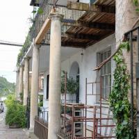
I was concerned about the state of Rock House, or at least its southern half, the last time I took a closer look at it while passing. Happily it seems to have been bought by someone prepared to fix up that drooping balcony. Here's hoping these repairs continue and my next photo of the place shows both sides of this old house (dated back to at least 1731 by a William Halfpenny engraving, no matter what the Listing says.)
Just behind Rock House you can see a bit of the Colonnade, sawn off at the end to make room for the widened Hotwell Road, I believe. Back in the day, according to 1925's The Bristol guide; being a complete ancient and modern history of the city of Bristol, the Hotwells and Clifton:
For those who prefer exercise to silting, there is the Colonade with shops, built beneath the rocks, and a parade about 800 feet long, shaded with trees, by the side of the river, so that the company may enjoy a dry and pleasant walk when it rains, or an airy, cool, and shady walk in the warmest season: also during the influx and efflux of the river, they may be entertained with the sight of the Merchant's ships, Steam packets, and Coasting vessels that generally pass up or down.
Tags: Bristol Places UK onemilematt united kingdom Clifton Village Hotwells Clifton
Auto-Tags: Plant Building Window Wood House Door Neighbourhood Residential area Real estate Facade Stairs Houseplant Urban design Cottage City
Text Recognition Tags:
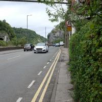
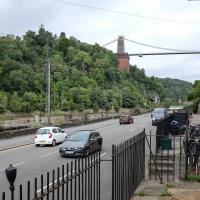
The Hotwell Road really needs more facilities for pedestrians. I spotted plenty of other walkers just on my brief trip along this short section, but all of us were being forced out to share the road with the busy traffic or prevented from crossing to the safer side and back as we made our way.
Thin pavements and a lack of crossings really show how much the car is king in this bit of Bristol, despite the gorgeous landscape.
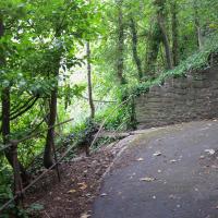
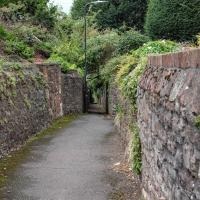
I did take a couple of other pictures of zigs and zags in the Zig Zag, but they didn't turn out too well; possibly my hands were shaking too much from the exertion of climbing this violently steep old track.
Tags: Bristol Places UK onemilematt united kingdom Clifton Village Hotwells Clifton
Auto-Tags: Plant Plant community Natural environment Natural landscape Wood Terrestrial plant Road surface Trunk Thoroughfare Woody plant Deciduous Groundcover Grass Landscape Tree
Text Recognition Tags:
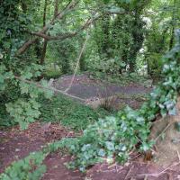
From near the top of the Zig Zag you can look down a couple of levels and see how vertiginous it is.
Tags: Bristol Places UK onemilematt united kingdom Clifton Village Hotwells Clifton
Auto-Tags: Plant Plant community Terrestrial plant Natural landscape Groundcover Tree Wood Grass Trunk Shrub Landscape Forest Soil Subshrub Temperate broadleaf and mixed forest
Text Recognition Tags:
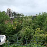
The reward at the top is the viewing platform of the Suspension Bridge, always busy with tourists.
I was actually planning to take an unexpected short-cut through a pub as an interesting little diversion on this wander, but sadly the pub was closed—I suppose before midday it's a bit of a reach to expect any pub to be open, even on a Saturday—so I headed for the shops instead. I'll have to do the short-cut trip one afternoon...
First I browsed the books at Rachel's & Michael's Antiques on Princess Victoria Street, where I bought CFW Dening's Old Pubs of Bristol as it mentions Hotwells a few times, then I grabbed my lunch from Parsons Bakery. There didn't seem to be anything new or interesting to snap along the way, so we'll now skip to the last couple of photos I took on my way home...
Tags: Bristol Places UK onemilematt united kingdom Clifton Village Clifton Clifton Suspension Bridge
Auto-Tags: Sky Cloud Plant Tree Fence Grass Shrub Travel Leisure Pole Luggage and bags Bridge Garden Girder bridge City
Text Recognition Tags: PENÁJR IN AVEN F PENÁJR IN AVEN F