Tagged: road-surface
Easter Monday Gardens and Flowers
18 Apr 2022
I didn't really set out with a theme of flowers and gardens in mind for this walk. I just fancied heading up to Clifton Village to get lunch. As it turned out, though, Spring was springing, so a minor theme emerged as I started off with the graveyard flowers of Hope Chapel and wandered up to see the beginnings of the new wildflower garden at Clifton Hill Meadow.
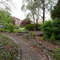
A lovely garden. Sadly a little lacking in facilities at the moment, after some scrote (or presumably a team thereof) had it away with their cast iron table and chair set at the end of March. This is why we can't have nice things, etc. etc.
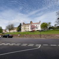
I've taken plenty of snaps looking at Holy Trinity from the road, but I think this may be my first looking at the road from Holy Trinity.
There was a somewhat precarious path in the road protected by those yellow plastic barriers to get around some holes being dug in the pavement. I chose the safer route through the church garden and thought I might as well take a pic from the main entrance.
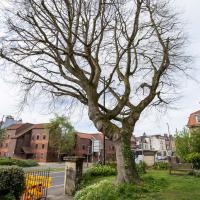
On a previous wander I posted a historical photo of the church including this tree, and one from the modern day.
It's grown up quite a lot in the last hundred years...
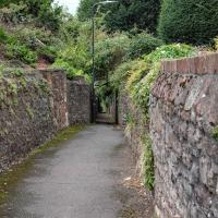
Strategically-placed grit box, because this tight blind (hence the mirror) zig-zag is hard enough work without a sheet of ice on the corner on a winter morning.
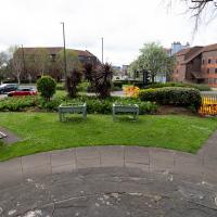
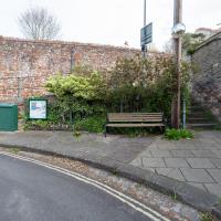
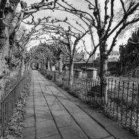
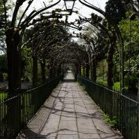
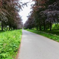
I thought I'd come and see how the wildflower garden was getting along. It's its first year, after a crowdfunder last year raised nearly £2000 to buy seeds, plug plants and signage.
Although the sign earlier said that you'd still be able to picnic here, I've never actually seen much picnicking. I think that's likely because of the danger of any round picnic items—around here more likely croquettes de foie gras than sausage rolls—escaping down the hill.
A Swing of the Plimsoll Bridge
24 Apr 2022
I was originally going to head over to the Ashton area to see if I'd missed any bits around the football stadium—and also to grab some lunch from the Tobacco Factory Market—but in the end I got a little distracted by having accidentally chosen exactly the right time to see the Plimsoll Bridge swing on one of the first busy days of Spring, where a lot of pleasure trips tend to head out down the Avon (and possibly the New Cut) from Hotwells.
In the end I mostly snapped that, and just a couple of photos from the Ashton area where I grabbed some lunch but didn't do any new exploring.
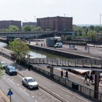
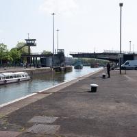
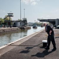
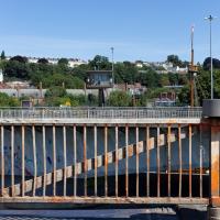
My first hint that there might be something interesting to look at was that the lock gates that I was planning on walking over were open rather than closed. Then I spotted the pleasure boat in the lock, just behind the descending steps from the footbridge there.
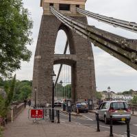
The Plimsoll Bridge is definitely not the oldest swinger in town. In fact, it may be the youngest swinger in town. I think the only other functioning swing bridges on the floating harbour (side-to-side rather than up-down like Redcliffe Bascule) are Junction Bridge (hidden in this picture, it's on the far side of the Cumberland Basin, carrying Merchants Road) and Prince Street Bridge, built in 1925 and 1879 respectively. The Plimsoll Bridge is mid-1960s.
Can't spot any music or a cafe in this photo? I don't blame you. But, if you look mid-left, you'll see a circular concrete plinth where the cafe used to stand near the children's playground in the heyday of the Cumberland Basin. And behind it is what caught my ear as I was crossing the lock gates—a saxophonist is practising his scales.
I've come across practising musicians in this area before. Presumably they've come away from home to avoid annoying the neighbours (or the rest of the family!) The traffic noise covers even unmuted brass quite well—by the time I was at the other end of the footbridge, on the far side of the flyover, I could barely hear him.
Ticking Off a Pocket of Paths in Leigh Woods
03 Jun 2022
I managed to go for a wander a while ago that was meant to finish off a little tangle of paths in Leigh Woods, or at the very least finish off my wandering of the Purple Path there. And I managed to miss doing either of those things through some kind of navigational incompetence.
Today I woke up with a bit of a headache, feeling a bit knackered as soon as I dragged myself out of bed, but at least with the energy to realise that I'd be better off (a) going for a walk in what looked likely to be the last of the Jubilee weekend sunshine than (b) moping around the flat until it started raining, at which point I could mope more thoroughly.
I had a look at my map, considered going to Ashton Court, but remembered that there was a music festival there today, and instead found these little leftovers of Leigh Woods and decided to have one more try at walking them.
At this point I'd just walked up the steep bit of Rownham Hill and was already too hot and a bit knackered. Still, at least it's levelling out.
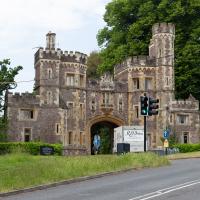
While my main target is Leigh Woods, I do also want to nip into Ashton Court and walk a little path I missed last time I was in the field with the little steam railway in it, so to the gatehouse we cross...
There was actually a gatekeeper today, as it's the weekend of the Love Saves the Day festival, being held at Ashton Court for the first time this year, I think. Happily, as long as you just want to walk a stretch of the grounds away from the festival site, they just wave you in. I wanted to walk a footpath behind the railway track I walked past back in...gosh! November 2020. I've been doing this a while, haven't I?
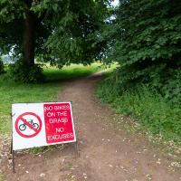
Guessing this is a polite hint from the golf club. In my mind's eye I can see an irate greenkeeper chasing a couple of mountain bikers in his golf buggy.
Time to exit Ashton Court and head for my main target at Leigh Woods.
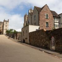
I rarely come in this way to Leigh Woods—it's basically the car entrance, and I almost always walk here. On those few occasions I've driven here, I've mostly parked on North Road near my usual pedestrian entrance through sheer habit, rather than driving in and using the official car park that's actually in the woods.
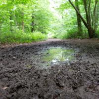
If it's rained for a few days in a row in Leigh Woods, some of the lower paths can get pretty muddy; in some past years I've even had to turn back and find another route, given that I mostly just wear ankle-high walking shoes. Today wasn't too bad.
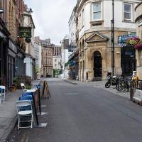
Right, back to Clifton Village for a coffee and some lunch to take home. I see the one way system—brought in as a social distancing measure—is still in place.
A Quick Swing Past Ashton Court
05 Jun 2022
Another day not dissimilar to my last wander: I'm feeling a bit tired and rather than just moping around the house I thought I'd find some tiny bit of somewhere that I'd not yet walked and get outdoors. This time I headed for the Tobacco Factory Market in Bedminster, as I often do, but went the long way around via Ashton Court Mansion as I knew there were some footpaths and a small section of road I'd not ticked off up there. Finishing all the Ashton Court footpaths will be quite a long job, but you've got to start somewhere...
I did feel rather better by the time I got home, and, pretty much astoundingly given the weather forecast, managed to avoid the rain completely.
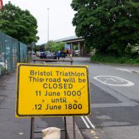
Ah, so it's the triathlon next weekend, then. The swimming bit is done in the Cumberland Basin, so I expect they'll be draining it and re-filling it with fresher water towards the end of the week. I wouldn't fancy it, even in a wetsuit.
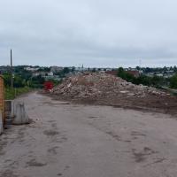
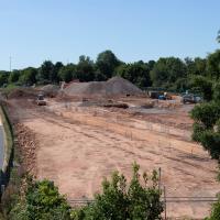
Looks like work has finally started on the new flats on the site of the former railway depot/concrete factory/Bristol International Exhibition site.
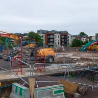
Yup, it's definitely all kicking off. They'll probably manage to build an entire development here before the Council finish fixing the bit of Cumberland Road that collapsed just around the corner.
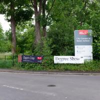
Ah, so not only is it the Bristol Triathlon next weekend, but it's also the UWE degree show. That's usually worth a look-see. Mind you, it's also Clifton Open Gardens, so maybe I'll see what the weather's like before I make a choice. UWE's Bower Ashton campus can be absolutely sweltering on a warm day, from what I remember, so I might be better off sipping Pimms in a garden if it's too sunny.
By which I mean that I saw something interesting coming but didn't have time to change the shutter speed and didn't think of panning in time.
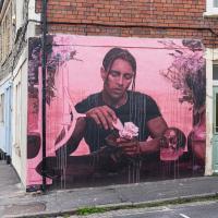
The technique that Ant Carver used for this piece, called "Love Me/Love Not", is intriguing. I recommend reading the write-up on the always-informative Natural Adventures.
I've been pretty awful at reading so far this year, apparently averaging about one book per month. That's a far cry from 2019, say, where I got through 41 books in the year. Today's wander was prompted by my rubbish reading, as I needed to go hand back some books to the library, because I'd managed to renew them so many times that I hit the limit on renewals. Oops. Several of them were still unread.
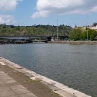
So, off to the Central Library for me, tail between my legs. On the way there I did my best to recreate a historical photo of Dowry Square; while I was in the area I walked under the adjacent Norman arch and poked around behind the Cathedral, and I also had a little diversion to the city centre and came back along the south side of the river, hitting some trouble with the lock gates as I finally crossed the harbour back towards home.
The same view these days is a lot less romantic, especially with the temporary crate from some roadworks sitting at the corner of the square.
I don't blame anyone who lives this close to the Hotwell Road (and can't get double glazing fitted because it wouldn't be in keeping with the character) for wanting a lot of trees and bushes in between them and the roar of the traffic, but I think it's objectively a lot less appealing to the eye with so much shrubbery in the way. Probably good for the local wildlife, though.
It's less obstructive in winter, as you can see from this earlier photo taken from the back of the square looking back toward me.
Samuel Taylor Coleridge and Robert Southey both spent time in the garden of the square, apparently—I wonder what they'd make of it today?
Off to the side of the photo we've just seen is the pub frontage on the Hotwell Road, apparently a later addition. The listing says
The right-hand return has a late C19 ashlar public house front with 5 panelled pilasters and foliate capitals to left-hand and central doorways, 2 windows with tripartite frames and semicircular-arched panes below, panelled aprons and dentil cornice.
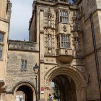
And now we've teleported down the Hotwell Road to College Green, where I found that the library wasn't open yet (I'd forgotten they didn't open until 1pm on a Sunday) so carried on past it and turned through an old Norman archway.
This was a section I wanted to walk, as although I have actually wandered through the arch and pottered around this bit of Bristol before, I think that was one of the days my GPS battery died halfway through a walk, so I never posted any records of it. Here I can redress the issue. We've seen the other side of this grand bit of architecture before, and the next photo has the information plaque which will tell you more about it more concisely than I could.
One fact that isn't on the plaque is that Catherine Hughes, the local artist who made the pomegranates for the front of the Cabot Cafe, had her studio in one of the upper rooms for a time. I presume this was wangled by her father, a local estate agent who was heavily involved in the whole College Green area. From the Clifton and Redland Free Press, 18 April 1900:
Comparatively few people are aware that the interesting structure known as the Abbey Gate House, College Green, the fifteenth century building above the fine old Norman archway, is now given over to the fine arts. It is the studio of Miss Catherine Hughes, and a private view of a charming exhibition of water colour drawings, by that young lady and Miss Ludlow, both local limners, was held last week, when a large number of ladies and gentlemen accepted the invitation to inspect the works, among the company being some local artists. Miss Hughes and Miss Ludlow studied under Ludovici in London, and are now following their profession in Bristol
The Mother's Ruin and Seamus O'Donnell's, just to the left here, are both good pubs. Sandwiched in between them at the moment is Shall Not Fade, who sell plants, vinyl records and clothes. The also, apparently, run a record label and a festival. I was tempted by a calathea, but I didn't want to be carrying it around for the next couple of hours. I'll have to come back another day.
For now, though, I escaped the hustle and bustle of Wapping Wharf by crossing Gaol Ferry Bridge—soon to be closed for "at least six to nine months" much to the distress of local businesses. And I imagine the local businesses know what the Council normally mean by "six to nine months": somewhere between two and three years would be my guess.
I'm in the habit of going over to the Tobacco Factory Market on a Sunday. I think I've walked all the routes around that way, but as a Plimsoll Bridge swing let me cross the road to the far side of Brunel Way on my return journey and I took a couple of photos of the brownfield development at the old Ashton Gate Depot site I thought I'd call it a Wander and pop some photos up.
But, of course, no Metrobuses, as they don't do anything as useful as running on a Sunday.
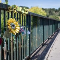
This small tribute caught my eye from the far side of the road. Sadly there are fatalities on Brunel Way most years. It's not the kind of accident black spot you find elsewhere in Bristol, but I suppose any 40mph dual carriageway with a lot of traffic will, sadly, have a death toll.
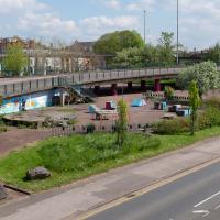
This drew my eye beyond to the new building going on on the old railway depot/tile merchant/etc. I wanted to cross to have a look, but the road seemed too busy.
Odd fact: Here I'm technically standing in Southville and taking a picture of Bedminster, as the dividing line between the two Bristol wards runs down the middle of Brunel Way at this point. Of course, everything in the distance isn't in any Bristol ward, as we're also looking at the Somerset border, which runs along the far side of the UWE Bower Ashton Campus.
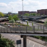
Ah, but it seems like the bridge is closing, which might make it nice and safe to cross over and have more of a look from the other side. First, though, we'll nip down and have a look at what's causing the swing.
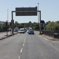
Now, what's actually meant to happen at this point is that all the traffic follows the giant flashing ALL TRAFFIC sign pointing to the exit ramp on the left. Then they go down the ramp, along a short stretch of road, cross the harbour at Merchants Road bridge (officially Junction Swing Bridge, in fact), join the Hotwell Road and continue on their merry way, without any cause for delay.
This never actually seems to happen, and a queue just forms here. Today this particularly annoyed the driver of a Waitrose van, presumably late for a delivery and stuck behind what he clearly thought were a line of idiots that he hooted angrily at for quite some time, to as much effect as you'd imagine.
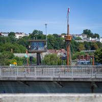
One of the things I like about Bristol is the strange contrasts. Here we have two crow's nests. The first is the Cumberland Basin Flyover System's Plimsoll Bridge control room, used to give the swing bridge operator a good view of the whole area surrounding the bridge. The second is the reason for the swing, the crow's nest on the tall mast of the replica of John Cabot's Matthew, as it passes through into Entrance Lock.
I walked back to the point I'd spotted all this activity from the far side of the road. This is the old tile merchant/concrete works/Ashton Gate Railway Depot/Bristol International Exhibition site. I imagine it was plenty of other things along the way, too. Here's an earlier snap with a bad photo from the far side of the site, but some detail on what the site was/will be along with a link to planning documents.
I'm currently toying with the idea of a little mini-website that takes a digitised and vectorised version of the Bristol International Exhibition plan (from 1914) and superimposes it on the same area today. It'd be interesting to see exactly where things were. My best guess from eyeballing it at the moment is that in 1914, this view would be looking towards the International Pavilion, Concert Hall and Art Gallery areas of the Exhibition, and we'd be standing on the train tracks that used to head for Ashton Avenue Bridge, which back then would have been a double-decker road and rail swing bridge, with the trains on the ground level deck, the road on the top deck, and a high-level swing control room above it all. Quite some feat of engineering.
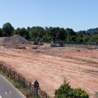
I wonder how many different things this patch of land has been over the years? I imagine it was one of the choice "brownfield" sites for some new flats down here. It's certainly doing its best to look very "brownfield" today!
Nipping Up the Zig Zag to the Shops
19 Aug 2023
It's been a long while since I did one of these walks.
I'm thinking of finishing up the project by walking one or two last bits of road, thus being able to declare with all honesty that I've done my best to walk every public road within my mile (and quite a few alleyways besides.) As a prelude, and just because I felt like it, I decided to drag out the camera and GPS on this little wander to the local shops.
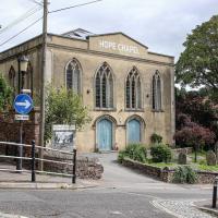
I may not personally be a fan of evangelical Christianity, but at least they keep the place looking nice. It's still very tidy since the recent renovation, installaltion of solar panels on the roof and repainting of the HOPE CHAPEL sign.
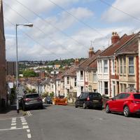
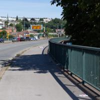
My exercise for the day is to be a short sharp shock: first we descend down Hinton Lane to the Hotwell Road, then I'm going to ascend the Zig Zag, and possibly die in the process. My fitness has suffered recently because although I've been keeping my step count up it's mostly been on the fairly flat commute to work and back, so hills are coming as a bit of a shock to the system at the moment.
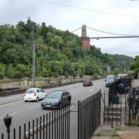
I would absolutely love to have lived in this area before World War II, before the widening of the road knocked down so many interesting things and replaced them with a few busy lanes of traffic, before the tramways were bombed into oblivion, and while you could still wander down to these moorings and catch a White Funnel boat out to Ilfracombe, or at least wander down to Hotwells Station and catch a steam train out to Shirehampton, Sea Mills or Avonmouth. Pre-1934 I could even have skipped the arduous walk up the Zig Zag and taken the 40-second ride up the funicular railway to Clifton Village...
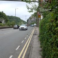
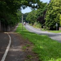
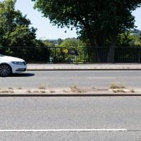
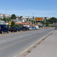
The Hotwell Road really needs more facilities for pedestrians. I spotted plenty of other walkers just on my brief trip along this short section, but all of us were being forced out to share the road with the busy traffic or prevented from crossing to the safer side and back as we made our way.
Thin pavements and a lack of crossings really show how much the car is king in this bit of Bristol, despite the gorgeous landscape.
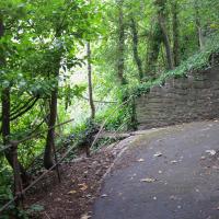
I did take a couple of other pictures of zigs and zags in the Zig Zag, but they didn't turn out too well; possibly my hands were shaking too much from the exertion of climbing this violently steep old track.