Tagged: te
Desultory Coffee Wander
16 Apr 2021
Another day, another quick dash out for a coffee. I did at least try to take a different route from normal, especially on the way back, where I yet again got a bit lost in the strange paths, flyovers and underpasses that make up the odd maze of pedestrian "infrastructure" among the concrete jungle between the west of Greville Smyth and my neck of the woods in Hotwells. I swear one day I'll take a turn I've not tried before and end up being gored by a Bristolian minotaur.
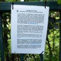
I'd heard there was going to be something of a wild party in Greville Smyth to mark the end of lockdown. It seems it may be the start of a regular thing, with a dance festival bringing 8,000 people to the park. I imagine I'll be able to hear it from my place, and therefore safely avoid it.
Tags: Bristol Places UK onemilematt united kingdom Bedminster Greville Smyth Park Ashton sign festival party
Auto-Tags: Plant community Plant Botany Natural landscape Terrestrial plant Vegetation Biome Grass Groundcover Font Forest Wood Shrub Signage Landscape
Text Recognition Tags: LICENSING ACT 2003 Application for the Grant of a Premises Licence & Paul Rooney of Radiosctive Clothing Limited TIA Slammin Events. Greville Smyth Park, Ashton Road, Ashton, Bristol, BS3 ZEA have submitted an application for the grant of a premises licence to Bristol City Council Licensing Authority, 100 Temple Street, Bristol BS1 SAG The record of the applicaeion may also be inspected at this address between .00 am and 6.00a pm Monday Friday. (Wednesday only. 10.00 am and 5.00 pm or on the Council's website at www.belatol.gox.uk The licence is being applied to cover a single three day avent, over a weekend in July ach year from 2021 te 2023. The esact date will be agreed with Bristol City Council in advance each year. The following dates relade to 2021 only. howevor the Bimes of operatlon are ed: Retail Saie of Alcohol Friy 23h uy 12:00 -22:10 Saturday 24 July 1200-22 10 and unday 25 July 12:00 -2140, Provision of Regulated Entertainment: Proviion of ve music recorded music wnd dance Fry 23 July 1200 22:30 Baturday 24 July 12:00-2230, and Bunday 1200 -22:00 Relevant persons and responsible authorities may make written reprenantation te the relevant Lconsing Authority by 4 May 2021. Such rapresentation shall be made in writing to Licensing Teameor PO BOK 339 Brienel B1 9NE vie smai Aano at.uk Ris an offence knowingy or reklessy to make a faise statement in connestion wh en oplcation and the masimum fine for which a peron is iable on summery conviction for the offence is an unmited e LICENSING ACT 2003 Application for the Grant of a Premises Licence & Paul Rooney of Radiosctive Clothing Limited TIA Slammin Events. Greville Smyth Park, Ashton Road, Ashton, Bristol, BS3 ZEA have submitted an application for the grant of a premises licence to Bristol City Council Licensing Authority, 100 Temple Street, Bristol BS1 SAG The record of the applicaeion may also be inspected at this address between .00 am and 6.00a pm Monday Friday. (Wednesday only. 10.00 am and 5.00 pm or on the Council's website at www.belatol.gox.uk The licence is being applied to cover a single three day avent, over a weekend in July ach year from 2021 te 2023. The esact date will be agreed with Bristol City Council in advance each year. The following dates relade to 2021 only. howevor the Bimes of operatlon are ed: Retail Saie of Alcohol Friy 23h uy 12:00 -22:10 Saturday 24 July 1200-22 10 and unday 25 July 12:00 -2140, Provision of Regulated Entertainment: Proviion of ve music recorded music wnd dance Fry 23 July 1200 22:30 Baturday 24 July 12:00-2230, and Bunday 1200 -22:00 Relevant persons and responsible authorities may make written reprenantation te the relevant Lconsing Authority by 4 May 2021. Such rapresentation shall be made in writing to Licensing Teameor PO BOK 339 Brienel B1 9NE vie smai Aano at.uk Ris an offence knowingy or reklessy to make a faise statement in connestion wh en oplcation and the masimum fine for which a peron is iable on summery conviction for the offence is an unmited e
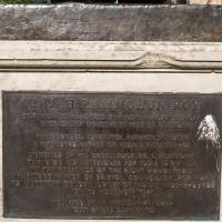
I managed to knock off a reasonable chunk of the roads I had left to walk around the University at the north-eastern extremity of my mile on this nice sunny walk. As well as being impressed by the number of big townhouses now occupied by various departments, I took some time on my way there to check out a war memorial, and some time on the way back to do a little extra wandering of Berkeley Square.
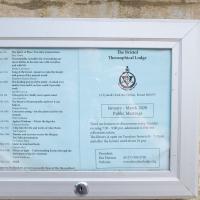
The Theosophical Society also lets its lodge be used by a variety of other organisations, including the Bristol Dowsers; a branch of Carlos Castaneda's Tensegrity folk (some of the videos of Tensegrity are quite something); a meditation group; and the local branch of the White Eagle Lodge, founded by a medium who received various teachings from the eponymous founder.
Given that those are the groups who openly practise there, I can only imagine the list of occult factions who use the rooms on other days...
Tags: Bristol Places UK onemilematt united kingdom Clifton Bristol Theosophical Lodge Theosophical Lodge theosophy
Auto-Tags: Rectangle Font Wood Commemorative plaque Landscape Symmetry History Memorial Public utility Circle Interior design
Text Recognition Tags: १८का Noy The Bristol Ihe Sprit at a Teabe ptia Theosophical Lodge ianer hatties becs vanale Sengtihe fesot-mt evkettee d prerd the rall Maten a Me mh Ihe bshng pewerthe id- det trdil d werk Taagrity orul adaat ind 14 Terudals Pukd. C. ri BS Y In kiry of lepale sad be January - March 2020 Public Meetings Mign e h Coesces catag -ke ptaette te Fe Ai d Wtheeg de l Acher Mad Adeiheld wel o Alke ley There are lectures or discuesionsaery Tday evening 70- 9:00 pm almisioe is te hit collectuns takem The libwary is open on Temdays Irom457m and after the lectune until about io pm. Mar un Te ed m thto Tee Tube tut Hes Oetinindan N enttigr t g kat he atda fne Prsident (OL17) 9047n5 www.beisthedodge ang Hei Hanon Webshe १८का Noy The Bristol Ihe Sprit at a Teabe ptia Theosophical Lodge ianer hatties becs vanale Sengtihe fesot-mt evkettee d prerd the rall Maten a Me mh Ihe bshng pewerthe id- det trdil d werk Taagrity orul adaat ind 14 Terudals Pukd. C. ri BS Y In kiry of lepale sad be January - March 2020 Public Meetings Mign e h Coesces catag -ke ptaette te Fe Ai d Wtheeg de l Acher Mad Adeiheld wel o Alke ley There are lectures or discuesionsaery Tday evening 70- 9:00 pm almisioe is te hit collectuns takem The libwary is open on Temdays Irom457m and after the lectune until about io pm. Mar un Te ed m thto Tee Tube tut Hes Oetinindan N enttigr t g kat he atda fne Prsident (OL17) 9047n5 www.beisthedodge ang Hei Hanon Webshe
A Trip to the Library
08 Jun 2021
I had to return a book to the library—Ellic Howe's Magicians of the Golden Dawn, very interesting, thanks for asking—so I decided to pick the Central Library as my drop-off point and walk down a segment of Deanery Road that I've surprisingly overlooked so far. In any normal time I'd have been walking to work that way quite often, or heading through at the weekend on the way to do some shopping in the city centre, or for a coffee at St Nick's, but those excursions have been quite thin on the ground for the last year or so, for obvious reasons.
I've never been inside a single building on Deanery Road itself; the Library is technically on College Green and the rest is mostly student accommodation or Bristol College buildings, by the looks of things. It's a fairly mediocre street, used merely to get to other places. (St George's Road, which merges into it, at least has the distinction of several good shops verging from the practical and long-lived car radio fitters to the excellent little Dreadnought Books, sadly currently closed for refurbishment...)
After dropping off my book I came home via the harbourside, the better to enjoy the nice sunny blue skies of the day.
Tags: Bristol Places UK onemilematt united kingdom City Centre college green
Auto-Tags: Black Temple Wood Grass Rectangle Font Tints and shades Art Sculpture Hardwood Concrete Hat Tree Soil Brick
Text Recognition Tags: RAJAH RAMMOHUN ROY BOR ON 22 A772 INIRADHANGAR BENGAL BED OM27 SREMGE TE ERISTOL FHILOSORHER REFORIZER, FATENOT, SCHOLAM FOUDINGATHER OE MIDIA EASSANCE UNVEILED DY HJE EXCELLENGY DR. LAISISG THE HGH COMMIESIONER FOR INDIA IN ITEE PPEFERCE OF THE RICHT HONOUBE THE HORDINAVOR DE BRISTOL, COUNCILLSACK SISIK. RAJAH RAMMOHUN ROY BOR ON 22 A772 INIRADHANGAR BENGAL BED OM27 SREMGE TE ERISTOL FHILOSORHER REFORIZER, FATENOT, SCHOLAM FOUDINGATHER OE MIDIA EASSANCE UNVEILED DY HJE EXCELLENGY DR. LAISISG THE HGH COMMIESIONER FOR INDIA IN ITEE PPEFERCE OF THE RICHT HONOUBE THE HORDINAVOR DE BRISTOL, COUNCILLSACK SISIK.
A Cliftonwood Revisit with Lisa
10 Jul 2021
Lisa had a couple of hours to spare before going up in a hot air balloon (exciting!) so we went for a quick local walk, revisiting a bit of Cliftonwood we've seen before, exploring the secret garden I'd visited before that I thought she'd enjoy (I didn't take any new photos there) and then pushing on to another garden, Cherry Garden. Last time we passed this way, I'd noticed the gate, but we hadn't gone in as I'd assumed it was private. I'd since found it on CHIS's list of communal gardens in Clifton, so I wanted to have a look inside this time, and try to figure out whether it was private-communal or public, and possibly Council-owned, like several of the other gardens in Clifton.
Seemed to be open and busy, which is good. It's always been a good, friendly pub, but I understand it's been on the verge of closure a couple of times recently.
Tags: Bristol Places UK onemilematt united kingdom pub City Centre St George's Road The Three Tuns Three Tuns
Auto-Tags: Window Building Infrastructure Plant Outdoor bench Facade Bench Outdoor furniture City Door Road Sidewalk Mixed-use Leisure Pedestrian
Text Recognition Tags: THREE TUNS Te o 2 THREL TUNS THREE TUNS Te o 2 THREL TUNS
Green Squares and Secret Gardens
31 Jul 2021
At the end of July I went to have a look around some of the private gardens opened up by the annual Green Squares and Secret Gardens event. Sadly it was compressed into a single day this year, for various Covid-related reasons, it seems, so I didn't get to poke around too many places. I went to:
- A talk by the oldest resident of Victoria Square
- The St Vincent's Rocks Hotel garden
- The Paragon garden
- Cornwallis Crescent gardens, both east and west
- The Polygon garden
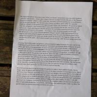
And snapped a few things in between, too. It was a lovely day—a bit too hot, if anything—and it was interesting to get into a few places I'd only ever seen from the outside, especially The Paragon and Cornwallis gardens, which are the least visible to passing strangers of all of them.
Tags: Bristol Places UK onemilematt united kingdom Clifton Village Clifton Cornwallis Crescent Garden Clifton Open Garden Squares Green Squares and Secret Gardens open day Cornwallis Crescent garden
Auto-Tags: Plant Grass Wood Font Rectangle Groundcover Terrestrial plant Grass family Commemorative plaque Paper Paper product Landscape Publication Document Pattern
Text Recognition Tags: Alhe ongeat Besdents Asooatten w n tact an Ownery Asoction n uy otheresidents sarvants and tnantamply datn'tcourt,ifwe are to jutge buan the Minuts of the eaure Ground Commttue whch in 1904 voted that taretoes and mer faes be et permitted to ae he plrae ground The ervants were dearly a problem, and in 12 e evatad alwng of Mers in the gendens s ogin droughta that he delinguents the ernt ot No2and t waireoked at the on Secnetany should wite to Mr. Esery ponting ut the e of actithe Canmitee eulbe forct to nahe reted the einquit n Ais aniceIta ey to beas ur predeeos but through the laboun of anore ar less ful-ine gadener e per wkin 18 they worted hard at cresting and mantaning the ganden we njny tody. Over the pears the Minutes book refers constantly to payments for eeh and shut, andtor the paths the lopping oftand the manteriance of the was-al of whah remainstnie ti day with the tres being partieular thefore he Camtt The gardemer tate tio epee It clear that toth heuses and gandes uffered dre eet setwthe as and for the folkowng 20 ywars Then in 1963 a Residents Aocutun was farmed whech emtraed the sgir af the age led by anewneration of owner aupies.and spitad tenantsa deteined attempe as made to mole etryane in the care of their haned anironmant The fact that eerol taf serp undanter rub ws of the state to which the prdns had deckned. There are stl a couple of ndents iing hers who took part in that massive dea e Weowe them agrst e We try to contue that self ep echos today, in the bellef that z fosters a samn of community All ptup residents er fleer paare tomatkally memters of the RA all havenght of acs to the garden Reponshlky for geting things done rests with everoe. The firat Sunda of she month is a'gandening elorning and we takein tus to mange the rkforce and alleate tasks. Keen gardeners are free moved d from the gardets is exidence enough s as much as they ke. Becently we haive been trying te manage he ganden to make mare wlfe frendly. We no Inngor spray the gravel path and we leave areasf the lawn unmwn to amcurage inects Some bird boons have teen pi u on the trees and Soses and badgers ane regar viston the latter not slwy welcome as they dig up the lan for wonms and gns dandeningrt, the grounds anea perfact plavaruund for chiidren and aduts ae de foctie, an anal bonfenight sctacule treasure hunts and bithday partiem, outdonr Shakeprare, carol singing sit doun meaand dancing in ourmarquee Lockdown in 2020 led to Cuckinghan Palace and the intraduction ofs fock of splenddy productive rescue hers, and this ar we started to plane truit ree aey The parden seemi to survive everything we thew t it, se far Alhe ongeat Besdents Asooatten w n tact an Ownery Asoction n uy otheresidents sarvants and tnantamply datn'tcourt,ifwe are to jutge buan the Minuts of the eaure Ground Commttue whch in 1904 voted that taretoes and mer faes be et permitted to ae he plrae ground The ervants were dearly a problem, and in 12 e evatad alwng of Mers in the gendens s ogin droughta that he delinguents the ernt ot No2and t waireoked at the on Secnetany should wite to Mr. Esery ponting ut the e of actithe Canmitee eulbe forct to nahe reted the einquit n Ais aniceIta ey to beas ur predeeos but through the laboun of anore ar less ful-ine gadener e per wkin 18 they worted hard at cresting and mantaning the ganden we njny tody. Over the pears the Minutes book refers constantly to payments for eeh and shut, andtor the paths the lopping oftand the manteriance of the was-al of whah remainstnie ti day with the tres being partieular thefore he Camtt The gardemer tate tio epee It clear that toth heuses and gandes uffered dre eet setwthe as and for the folkowng 20 ywars Then in 1963 a Residents Aocutun was farmed whech emtraed the sgir af the age led by anewneration of owner aupies.and spitad tenantsa deteined attempe as made to mole etryane in the care of their haned anironmant The fact that eerol taf serp undanter rub ws of the state to which the prdns had deckned. There are stl a couple of ndents iing hers who took part in that massive dea e Weowe them agrst e We try to contue that self ep echos today, in the bellef that z fosters a samn of community All ptup residents er fleer paare tomatkally memters of the RA all havenght of acs to the garden Reponshlky for geting things done rests with everoe. The firat Sunda of she month is a'gandening elorning and we takein tus to mange the rkforce and alleate tasks. Keen gardeners are free moved d from the gardets is exidence enough s as much as they ke. Becently we haive been trying te manage he ganden to make mare wlfe frendly. We no Inngor spray the gravel path and we leave areasf the lawn unmwn to amcurage inects Some bird boons have teen pi u on the trees and Soses and badgers ane regar viston the latter not slwy welcome as they dig up the lan for wonms and gns dandeningrt, the grounds anea perfact plavaruund for chiidren and aduts ae de foctie, an anal bonfenight sctacule treasure hunts and bithday partiem, outdonr Shakeprare, carol singing sit doun meaand dancing in ourmarquee Lockdown in 2020 led to Cuckinghan Palace and the intraduction ofs fock of splenddy productive rescue hers, and this ar we started to plane truit ree aey The parden seemi to survive everything we thew t it, se far
Museum of the Moon, and a Bit of Redland
21 Aug 2021
Lisa and I mostly went out to have a look at Luke Jerram's Museum of the Moon as its tour hit Bristol Cathedral—I missed it when it was previously in town, at Wills Hall, I think—but we also took a trek up to Redland. Lisa's kind enough to indulge my strange current fascination with the Edwardian eccentrics that made up the Stella Matutina, so we swung by a couple of places with a vague connection to the Bristol branch of the organisation. Well, it was good walking, anyway...
As a stunning bonus, one of the picture's descriptions has more information than you'd probably want on the Bristol Port Railway and Pier's Clifton Extension Railway line, but I did happen to coincidentally write up this wander after reading about the extension line during my lunch hour at work today. It's a thrilling life, I tell you...
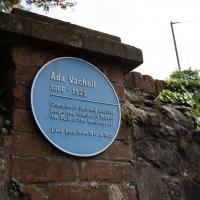
Can't resist a plaque. The original name of the organisation was "Guild of the Brave Poor Things", but that's Victorians for you.
Tags: Bristol Places UK onemilematt united kingdom plaque Redland Ada Vachell
Auto-Tags: Sky Street light Leaf Vegetation Font Grass Plant Groundcover Landscape Commemorative plaque Signage Sign Brick History Tree
Text Recognition Tags: Ada Vachell 1866- 1923 Champlon et pee End dialud people and tounde in 1293 the Colld ef the Handicapped Lived here irum 1510 te 1923 Ada Vachell 1866- 1923 Champlon et pee End dialud people and tounde in 1293 the Colld ef the Handicapped Lived here irum 1510 te 1923
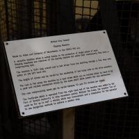
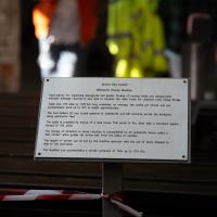
I'm afraid that this is a bit of a badly-curated wander, where I mostly just popped out to find out a little of the history of Underfall Yard and poke around the various open workshops, and, in hindsight, really didn't take pictures in any kind of coherent order. So there's a lot of pictures, but they don't really tell the story that, in hindsight, I seem to have been trying to tell, of the unusual electrical substation in Avon Crescent, the Bristol Electricity that predates the National Grid but is still in use, the history of the hydraulic power house... It's a bit of a mess.
But I suppose sometimes these wanders—always chronologically presented in the order I walked and took photos—simply will sometimes be a bit of a mess. Let's hope you still get something out of it, anyway...
Tags: Bristol Places UK onemilematt united kingdom Hotwells Underfall Yard Spike Island Docks Heritage Weekend
Auto-Tags: Font Material property Event Pattern Mesh Memorial Wood Signage History Commemorative plaque Metal Transport Paper
Text Recognition Tags: Bristal City Cup aping Masbina Made by Hde and Cengany of Mabeeter, the 1880/90 a A versatle acbine whih is witel nalaly te the prouction af vrge pe of w Shaping asbin ar reative of the planing maina e tr tararta Day han reelprocating toel. The naphine la tort long vera sd a halt en frem e shafting tbrg fu g puley at the ieft hand vod The langth af vtroke can be variel by thn takng of tw large wa on the drive trie The ram is fed siung the machine ty s esd sorew whiut can be rotatad wtber by hand u A pew and ratchet mechanin rlvn by the sam att w prs the rem mehastan The ram reciprocating speed an be variet tn 10 d 30 vtroke pe ita The foothrake which is operatel fron the right hand end of the saibine was t ly the Port of Bristul Autherity to stop noveent qickty. Without the trsks De sautios 'ne o codd be for uo to balf minute which wan nnint and a tengtatian for the operatar to ne dangeraun metos to adieres sker stas Bristal City Cup aping Masbina Made by Hde and Cengany of Mabeeter, the 1880/90 a A versatle acbine whih is witel nalaly te the prouction af vrge pe of w Shaping asbin ar reative of the planing maina e tr tararta Day han reelprocating toel. The naphine la tort long vera sd a halt en frem e shafting tbrg fu g puley at the ieft hand vod The langth af vtroke can be variel by thn takng of tw large wa on the drive trie The ram is fed siung the machine ty s esd sorew whiut can be rotatad wtber by hand u A pew and ratchet mechanin rlvn by the sam att w prs the rem mehastan The ram reciprocating speed an be variet tn 10 d 30 vtroke pe ita The foothrake which is operatel fron the right hand end of the saibine was t ly the Port of Bristul Autherity to stop noveent qickty. Without the trsks De sautios 'ne o codd be for uo to balf minute which wan nnint and a tengtatian for the operatar to ne dangeraun metos to adieres sker stas
Tags: Bristol Places UK onemilematt united kingdom Hotwells Underfall Yard Spike Island Docks Heritage Weekend
Auto-Tags: Font Event Room Public event Carmine Magenta Signage Audio equipment
Text Recognition Tags: B oty Dea wwerth Pa Mae Ud y fer wa g sinegate nd L ham f ri and rerent it at ty it w md to sake the tre for m L wng BriA Table wee ar we y 14tG ang te m anraga te y pw niste nd se e dte werk a to Gft ia arenates The toe ers th rael pard or d traver aro te werkl g satana te the tale prled ky e efa ad ar Thie sere s dis un A tentert spare thread of in TM shege of aetion l rretation l an ya tatie ve calada t striker w the iv at freN e er to anather The lengn uf str et ty the a wster w ihe se of sto pd t f the vrktak The s odataastre veriates of 10 e k B oty Dea wwerth Pa Mae Ud y fer wa g sinegate nd L ham f ri and rerent it at ty it w md to sake the tre for m L wng BriA Table wee ar we y 14tG ang te m anraga te y pw niste nd se e dte werk a to Gft ia arenates The toe ers th rael pard or d traver aro te werkl g satana te the tale prled ky e efa ad ar Thie sere s dis un A tentert spare thread of in TM shege of aetion l rretation l an ya tatie ve calada t striker w the iv at freN e er to anather The lengn uf str et ty the a wster w ihe se of sto pd t f the vrktak The s odataastre veriates of 10 e k
A winch that can heft the Matthew up the Patent Slip is pretty impressive.
Tags: Bristol Places UK onemilematt united kingdom Hotwells Underfall Yard Spike Island Docks Heritage Weekend
Auto-Tags: Motor vehicle Font Gas Automotive exterior Signage Wood Poster Advertising Art Facade Automotive wheel system Tree Automotive tire City Metal
Text Recognition Tags: THE WINCH SHED The winding gnar and motor used to pull boats out of the water are in the Winch Shed at the top of the sipaay tt te hy y on the ich o Whn sv t he tat the pa y an The heu Jn nd MU HEART OF THE HARBOUR 22 THE WINCH SHED The winding gnar and motor used to pull boats out of the water are in the Winch Shed at the top of the sipaay tt te hy y on the ich o Whn sv t he tat the pa y an The heu Jn nd MU HEART OF THE HARBOUR 22
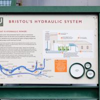
...is worth a thousand words. As you can see from the map, hydraulic power from the accumulator can be used to power things all around the harbour, including to swing Prince Street Bridge, about a mile away. Impressive.
Tags: Bristol Places UK onemilematt united kingdom Hotwells Underfall Yard Spike Island Docks Heritage Weekend
Auto-Tags: Font Plant Gas Machine Signage Tree City Facade Advertising Billboard Engineering Winter Display device Sign Public utility
Text Recognition Tags: U BRISTOL'S HYDRAULIC SYSTEM WHAT IS HYDRAULIC POWERI Hyde poerp e k y opertra. Powe canbeet overlang ditares Detan yctae pow, oratonsn a opering lok go Snging bigen and uadryc wth ty a te n A he eat O Te oura tect poarh pir a b britgd The H Ri U BRISTOL'S HYDRAULIC SYSTEM WHAT IS HYDRAULIC POWERI Hyde poerp e k y opertra. Powe canbeet overlang ditares Detan yctae pow, oratonsn a opering lok go Snging bigen and uadryc wth ty a te n A he eat O Te oura tect poarh pir a b britgd The H Ri
Fresh Fields
17 Oct 2021
For the first time in a while, I had the time and energy to go further afield and knock off some new roads from my "to do" list. I headed through the first Hotwells Festival to Ashton and Bedminster to cross off a few of the suburban roads south of North Street.
First, though, I decided to try to reproduce an old photo of the now-demolished Rownham Hotel just around the corner from where I live...
ODE says a "bower" is "a pleasant shady place under trees or climbing plants in a garden or wood." This road (in the Ashton district) is actually pointing in the direction of the UWE campus at Bower Ashton—I wonder if it was named because it led towards that bower?
Tags: Bristol Places UK onemilematt united kingdom Ashton Bedminsterg
Auto-Tags: Car Tire Wheel Land vehicle Vehicle Cloud Plant Sky Motor vehicle Vehicle registration plate Tree Asphalt Road surface Mode of transport Automotive exterior
Text Recognition Tags: SCAFT WEST UNTE Te UTBET EA67 FRR SCAFT WEST UNTE Te UTBET EA67 FRR
I went out simply wanting to knock off the very last little unwalked section of Clanage Road, over by Bower Ashton, which has been annoying me for a while as it's quite close by and I've walked the other bits of it several times. So, my plan was to nip over to Greville Smyth Park via a slightly unusual route to wander Clanage Road and tick it off.
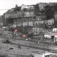
Along the way, though, I inevitably got a bit distracted. I took a few photos of Stork House, a grand Hotwell Road building that's recently been done up a bit (I imagine it's student lets, though I'm not sure) and which I found a reference to in a book about the Port Railway and Pier the other week, and also tried to match up a historical photo of Hotwells before the Cumberland Basin Flyover System laid it waste, which included some interesting markers I'll have to do a bit more digging into...
I found this image on Pinterest and as usual for that site it was annoyingly uncredited, but it seems to be from the book Hotwells, Spa to Pantomime, which I've just ordered direct from Bristol Books. Hopefully I'll be able to update the credit a bit when it arrives.
There's quite a lot in here that I didn't know about and will be researching a bit more, especially the Spa Assembly Rooms, which I think later turned into a school before being demolished for the flyover system, and also Anderson's workshop, a last vestige of the figurehead-carving industry.
Tags: Bristol Places UK onemilematt united kingdom Hotwells Cumberland Basin Flyover System Brunel's Other Bridge Terrett Memorial Hall assembly rooms Anderon's Workshop Brethren Chapel Rownham Inn Sopey Park
Auto-Tags: Building Infrastructure Sky Neighbourhood Landscape Monochrome Residential area City Monochrome photography House Urban area Window History Road Urban design
Text Recognition Tags: orweus r wesCI BAA Maryof g hetowanolhed tan O a O he Cup And r Te Mee H O S Assenty ee Orels Harived orweus r wesCI BAA Maryof g hetowanolhed tan O a O he Cup And r Te Mee H O S Assenty ee Orels Harived
The Gridiron and Bower Ashton Part Two
03 Dec 2021
On my last wander, to Bower Ashton, I was intending to knock Blackmoors Lane off my list "to-do" list, but got a bit diverted. I also took a little look into the history of the Gridiron, once a cheaper alternative to dry dock that was nestled just south of North Entrance Lock.
Today I had to go to send a parcel off somewhere, so I decided on going to the North Street Post Office via Blackmoors Lane. I didn't have much intention of anything else, but as luck would have it I walked out both at low tide and also as some lockkeepers seemed to be having a bit of a training session, and one of the more senior people was (a) happy to answer a few random questions on the Gridiron and (b) actually knew a lot about it, as Gridiron maintenance had been one of his jobs, more than twenty years ago...
So I might have missed the deadline a bit, then. Just as well I don't own any land around here...
Tags: Bristol Places UK onemilematt united kingdom sign railway Bower Ashton notice
Auto-Tags: Botany Grass Line Font Cylinder Gas Groundcover Public utility Natural landscape Trunk Signage Composite material Natural material Nature reserve Wood
Text Recognition Tags: below, quoting the eference MWUNREEby ree t you have any legel interest in, on, er over the land nant, ocpier o any other interst i the and shoen the ppended plan whether as ower, le ardent SECTIONLAND 44 PLANNNGATZ MORTH BOMERSET COM PROPOS WETROWEST PA ToA TANTNEORI Marth Somant Council intends Secretary of S under the Planring Act t Devalopment Consent Order (DCO)onstt sperate w station at Portishat. wpen e fomar statien al P and reopen te Porheal rail ine as wt as other powen de aling lne betsen Pl and Parson ets THANA CRY pe contact Charlette Pots on the contd he 1 n 20s pt cas bw fo below, quoting the eference MWUNREEby ree t you have any legel interest in, on, er over the land nant, ocpier o any other interst i the and shoen the ppended plan whether as ower, le ardent SECTIONLAND 44 PLANNNGATZ MORTH BOMERSET COM PROPOS WETROWEST PA ToA TANTNEORI Marth Somant Council intends Secretary of S under the Planring Act t Devalopment Consent Order (DCO)onstt sperate w station at Portishat. wpen e fomar statien al P and reopen te Porheal rail ine as wt as other powen de aling lne betsen Pl and Parson ets THANA CRY pe contact Charlette Pots on the contd he 1 n 20s pt cas bw fo
