Tagged: history
Bedmo and Ashton Court
21 Nov 2020
A rather more wide-ranging weekend wander with Sarah and Vik, taking in some mock Tudor bits of Bedmo (I should note that I've subsequently been corrected to "Bemmie", but I'm an outsider and have been calling it "Bedmo" for short for decades...), a chunk of Ashton, a path up Rownham Hill called Dead Badger's Bottom(!), The Ashton Court estate, a bit of the UWE campus at Bower Ashton, and some of the Festival Way path.
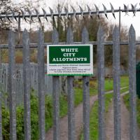
Gosh. I had no idea why it's called the White City Allotments, but apparently:
Bristol International Exhibition opened in May 1914 promising to be 'a place of pleasure and delight', celebrating 'the resourcefulness and progress of Great Britain and her Dominions'. 32 acres in Ashton Gate were transformed by palaces and pavilions. It quickly became known as the ‘White City’ because of the plaster used on the temporary buildings.
Green Squares and Secret Gardens
31 Jul 2021
At the end of July I went to have a look around some of the private gardens opened up by the annual Green Squares and Secret Gardens event. Sadly it was compressed into a single day this year, for various Covid-related reasons, it seems, so I didn't get to poke around too many places. I went to:
- A talk by the oldest resident of Victoria Square
- The St Vincent's Rocks Hotel garden
- The Paragon garden
- Cornwallis Crescent gardens, both east and west
- The Polygon garden
And snapped a few things in between, too. It was a lovely day—a bit too hot, if anything—and it was interesting to get into a few places I'd only ever seen from the outside, especially The Paragon and Cornwallis gardens, which are the least visible to passing strangers of all of them.
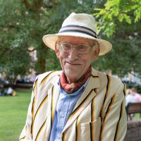
Kicked off my Clifton "secret gardens" visit by attending a talk by Victoria Square's "oldest resident", who is 95 and has lived there all his life. He did mention his family name in passing, but I've got a memory like a sieve, and his name's not on the event details. Ah well.
He really brought the square to life, with memories of the children playing in the square, making their way between the two halves using the tunnel—which I learned also had enough room to store the gardener's equipment, so must have been bigger than I thought!—and with the oldest child having a garden key hanging around their neck on a bit of string, ready to use when each family used a distinctive sound—anything from a whistle to a cowbell—to call the kids back home. He also touched on delivery men, including horsedrawn milk carts that would fill maids' jusgs from their churns, and the Walls ice cream boy who would visit houses who had hung the distinctive "W" sign in their windows on a Sunday, and gave many other amazing details. I really wish I'd recorded the event.
Among other new tidbits I can recall:
- Number 4 was blown to smithereens during WWII, hit so badly by a German bomb that bodies were blown into Mortimer Road. Grim.
- The "pinch point" made by the railings below the Arch House were motivated by a battle between the residents, and the Council and Merchant Venturers (who basically built/owned the Square, hence the adjacent Merchants Road) over a road that was planned to run diagonally through the square (as actually happened with Queen Square). The pinch point was constructed to preserve the maximum width of the existing right of way through the corner, making it too narrow for cars.
- The Victora Square Hotel used to be the vicarage for St Andrew's Church. Our Oldest Resident attended Sunday School there.
- The old [Church/Church Hall](htt
One Albermarle Row, Granby Green and... People
12 Mar 2021
I was browsing some historical photos the other day, and came across "Rear of Unspecified House" in the Bristol Archives' John Trelawny Ross collection, and immediately recognised it as being the back of 1 Albermarle Row, just around the corner from me. I've not had much time to research the history of this odd little addition to Albermarle Row, or what happened to 1-4 Cumberland Place, number 4 of which used to be attached to the side of 1 Albermarle Row, but it was interesting to look at old maps for a few minutes and work out what used to be where.
That all connects with the little local bit of land at Granby Green, too, as it used to be numbers 1-3 Cumberland Place. There was something of a planning battle over Granby Green, and I've included an old edition of Hotwells & Cliftonwood News that I found online, a copy of which would have been popped through my letterbox at the time.
I was also inspired by some old pictures of Hotwell Road to try to put a few more people in my pictures, though I set my pre-focus a couple of extra metres out from normal to make sure I didn't get too close to anyone!
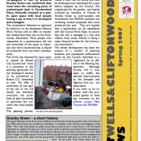
"Rear of unspecified house, Jun 1979"
As soon as I saw this photo, I thought, "That's not unspecified! That's 1 Albermarle Row!" I mean, it still looks like that today, and it's quite distinctive.
From the Bristol Archives, filed under "Bristol City Council: Urban Design and Conservation: Photographs by John Trelawny-Ross/ Photographs taken by John Trelawny Ross during the course of his work as conservation officer for Bristol City Council, within the Urban Design and Planning Department/Dowry Parade, Albermarle Row and St Vincents Parade"
The more I research it, the more I find that Hotwells had far better transport links back in Victorian and Edwardian times than it has today. Along with buses that went to more useful places than the City Centre, there were trams, the funicular up to Clifton, the landing stage for paddle steamer services and two railway stations all within easy walking distance of me.
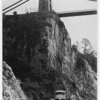
Today I took a day off work as preparation for doing the bookkeeping for my tax return1, and took a wander along to the site of what would have been my nearest station, Hotwells (or Clifton, as it started out in life), nestled in the shadow of the suspension bridge, the Bristol terminus of the Bristol Port Railway and Pier.
From there I wandered down the Portway, following the original line, until I got to the area around Sneyd Park Junction, where the tunnel from the slightly later Clifton Extension Railway joined up with this originally-isolated BPR line. Then I headed up to Clifton through the "goat gully" at Walcombe Slade, seeing the few above-ground bits of evidence of the tunnel (which is still in regular use) along the way.
It was a lovely day, and a good walk, and it was interesting to daydream of the times when I could have walked a few minutes from my flat down to Dowry Parade, caught a short tram ride to Hotwells Stations, and then headed from there to Avonmouth, perhaps even to board a transatlantic passenger service. The completion of the Clifton Extension Railway that linked the Avonmouth station with Temple Meads made relatively direct transatlantic travel from London via Bristol possible, with passengers travelling up from Paddington to Temple Meads, on to Avonmouth on the Clifton Extension Railway and Port Railway and Pier line, then perhaps catching a Cambpell's paddle steamer—which sometimes acted as tenders for large steamers—to a larger ship that was headed out for Canada, say.
1 I've learned that the best approach is to take two days off and deliberately do something that's not my bookkeeping on the first day, as otherwise I just inevitably end up procrastinating and feeling guilty on the first day no matter what. I have an odd brain, but at least I'm learning strategies for dealing with its strange ways as I get older...
2 Information mostly gleaned from Colin Maggs' The Bristol Port Railway & Pier and the Clifton Extension Railway, The Oakwood Press, 1975.
Here we see the Portway road, presumably fairly shiny and new, after many, many things, including the railway line from Hotwells to Sea Mills, were removed to make way for it. As you can see, they've done a splendid job of redeveloping the space where the station was into a little mini-park area, back in the day when the traffic wasn't a constant rush of noise and fumes and you didn't have to scamper across like you were playing a game of Frogger. It might well have been a pleasant place to sit. It certainly wouldn't be now.
Also, guess what there is fencing in the park area? Yes, some nice iron railings. I have no idea whether these are same ones I found—today's seem in surprisingly good nick considering this photo would have likely been taken almost a hundred years ago, and also how many railings were torn up during WWII.
This photo was taken before the war, as you can see a tram still running in the background—a Luftwaffe bomb took the tram system down in 1941 and it was never replaced. It also was obviously taken after 1926, as the Portway opened to traffic on 2 July 1926, having cost £800,000 to build, about £47m in today's money. So, that fixes it to a 15-year period, I think, but I'm not enough of a historian to be able to pin it down further.
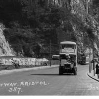
Bottom section of the postcard. I like the way there's a bus and a tram in it, but I'd quite like the bus not to be there so we can see the whole of the former station site. Motion blur makes it hard to figure out the bus and tram details.
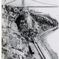
This photo comes from the M Oakley Collection via a scan from Branch Lines Around Avonmouth, by Vic Mitchell and Keith Smith, ISBN 190447442X. My reproduction quality isn't great, but hopefully you can see Hotwells Station as it was in its early years, including the turntable at the far end, just in front of the stationmaster's house, to the left of the booking office.
Later the turntable was removed and the tracks extended all the way to the end to make the most of the limited platform space; the engine would move onto the centre run-around track in advance, then pull the carriages into the station on the other track using a draw-bar instead of using the turntable to run around them after it had pulled them in.
My favourite tidbit from Colin Maggs' The Bristol Port Railway & Pier is the last bit here:
Around the turn of the century, a stationmaster at Sea Mills kept poultry, pigs, a cow and used his pony and trap to fetch swill from the docks. He sold eggs to passengers and provided the the Superintendent at Bristol with butter and new-laid eggs. Another character was a driver nicknamed ‘Mad Jack’. He enjoyed scaring the dockers to death by rushing through the tunnels into Hotwells, once misjudging his braking power and crashing into the buffers.
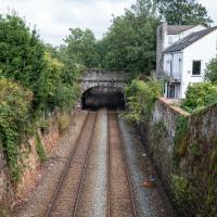
Must've been quite unnerving, racing out of the tunnel straight towards the cliff face at speed!
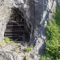
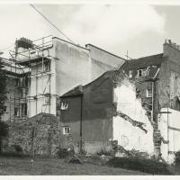
Of course there's graffiti in there. This was, apparently, used as a stable!
Further to improve the ventilation provided by the two vertical shafts, in 1950 an old shaft leading out to the face of the gorge was re-opened after having been blocked for many years. Originally it had been used as a stable for ponies employed in tunnel construction. A ganger's cabin is hewn out of the side of the tunnel and is on the down side approximately midway.
— Colin Maggs, The Bristol Port Railway & Pier and the Clifton Extension Railway, The Oakwood Press, 1975
Museum of the Moon, and a Bit of Redland
21 Aug 2021
Lisa and I mostly went out to have a look at Luke Jerram's Museum of the Moon as its tour hit Bristol Cathedral—I missed it when it was previously in town, at Wills Hall, I think—but we also took a trek up to Redland. Lisa's kind enough to indulge my strange current fascination with the Edwardian eccentrics that made up the Stella Matutina, so we swung by a couple of places with a vague connection to the Bristol branch of the organisation. Well, it was good walking, anyway...
As a stunning bonus, one of the picture's descriptions has more information than you'd probably want on the Bristol Port Railway and Pier's Clifton Extension Railway line, but I did happen to coincidentally write up this wander after reading about the extension line during my lunch hour at work today. It's a thrilling life, I tell you...
There's actually a Hotwells connection here, fairly literally. This section of track, from Ashley Hill, Montpellier, Redland, this bit right here, then Clifton Down and through a tunnel under the Downs to Sneyd Park Junction and Sea Mills station, was built as the Bristol Port Railway extension line, the Clifton Extension Railway.
The original Bristol Port Railway and Pier connected Hotwells to a deep-water pier at Avonmouth (with a few stations along the way) avoiding the need to have ships wait for the right tide to come into Bristol to unload. We've previously been inside one of its tunnels.
It was also used by plenty of passengers—during WWI an extra platform was added in Hotwells to cope with the sheer number of Bristolians commuting to the docks and munitions factories daily as part of the war effort, as well as troop movements and incoming wounded on hospital trains.
Later on this isolated Bristol Port track needed to join up to the existing railway network to survive, so this extension line was added to connect it with Ashley Hill with help from the Great Western and Midland railways. Only later did the section to Hotwells fall into disuse and close in favour of the Portway road.
(Information mostly courtesy Colin Maggs' The Bristol Port Railway & Pier, Oakwood Press, 1975.)
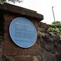
Can't resist a plaque. The original name of the organisation was "Guild of the Brave Poor Things", but that's Victorians for you.
The End of a Private Road
27 Oct 2020
One of the homes in Windsor Terrace went on the market for £2,000,000 a few years back. This is the closest I've been to it, right at the end of the private road. Presumably they're okay with people wandering down the road if there's a blue plaque to be seen at the far end?
Both the plaque to Edward St John Daniel and the other photo I took (in these early walks I was mostly walking, rather than mostly taking photographs) have interesting stories of a rise and fall associated with them in the first Google hits I found. Daniel was indeed the youngest recipient of the VC, but was stripped of the medal by Queen Victoria herself in 1861, following conviction for desertion and evading court martial. Lubetkin is probably most famous for designing the penguin pool at London Zoo, which was closed 17 years ago, after the micro-abrasions in the penguins' feet caused by the concrete led to them developing an infection with the charming name "bumblefoot".
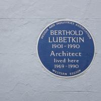
Designer of, among other things, the London Zoo penguin pool, and Highpoint, described by Corbusier as "This beautiful building .... at Highgate is an achievement of the first rank", and I like Corbusier's ideas, having read about them in How to Make a Home, I think, so that was what caught my eye on the Wikipedia page.
Local
03 Nov 2020
A very local exploration today, but there are still bits of the near field that I never need to walk down, so it didn't take me long to find somewhere I haven't been in a decade or more, the little enclave of smaller Victorian houses around Oldfield Road and Sandford Road. I'd really like to live in one of those houses, but I doubt I could afford it.
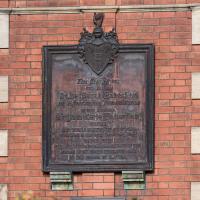
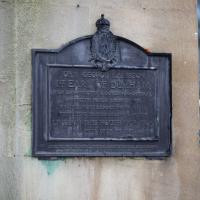
This Charity was FOUNDED BY Dame Sarah Haberfield In Affectionate Remembrance OF HER HUSBAND, Sir Jobn Kerle Fabertied KNIGHT SIX TIMES MAYOR OF BRISTOL, Who Died on the 27th December, 1857 HAVING BEEN FOR MANY YEARS AN INHABITANT OF THE PARISH OF ST. MARY REDCHEFE AND OF THE PARISH OF CLIFTON
Very Local
06 Nov 2020
It's surprisingly easy to overlook the giant Wesleyan Grenville Chapel—now converted into flats—if you've lived here a while. Other sights that seem to slip from my memory include the modest Ashton Avenue, a tidy terrace of little houses on a road that presumably gave its name to the Ashton Avenue bridge.
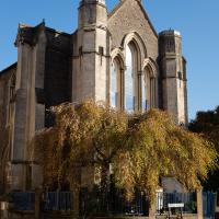
There is no view of this chapel that isn't obsured by something, I think. Nice tree, mind. It's flats, now, of course.
Little Clifton Village Details
09 Nov 2020
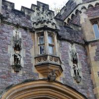
I like The Paragon as a terrace, especially the bowed porches. On the other side of the road, a house attic has a stone lion surrounded by rocaille leaves, according to its listing.
I also love the detail of the arrows in the wrought iron of The Mall's balconies. Today I discovered Westfield place, a road I'd never encountered that runs up to the rear of the Coronation Tap. (It's a famous local cider pub, but I've only been in a couple of times. I'm more of a beer man.)
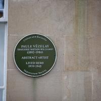
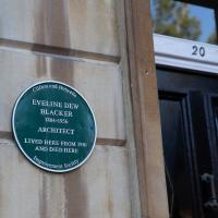
I'm not entirely clear how a Bristolian called Marjorie Watson-Williams ends up moving to Paris, changing her name to Paule Vézelay, and becoming a famous painter of the abstract school, but it must have been quite a fun ride, surely...
She returned to Bristol when war broke out and apparently spent the first few years in Rodney Place.
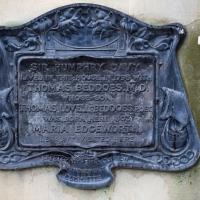
I was particularly intrigued by "MARIA EDGEWORTH his aunt visited here". It's this Maria Edgeworth, a prolific writer, apparently. "She was the second child of Richard Lovell Edgeworth (who eventually fathered 22 children by four wives)", so I imagine Thomas Beddoes had quite a few aunts...
Clifton Village: Jesus and the Tympanum
12 Nov 2020
My goal is walk down every public road within a mile of me; sometimes it's not easy to tell what's public. I've passed the turning for Cornwallis Grove a thousand times, but never had a reason to venture down it, and although the street signs at the end seem to be council-deployed and I didn't spot any "private" signs, it's a gated road and definitely feels private.
Gathering all the white middle-class privilege I could muster, I wandered down and was rewarded with the sight of a Victorian pump, a statue of Jesus, and from the end of the road, a view of a private garden that once belonged to a private girls' school.
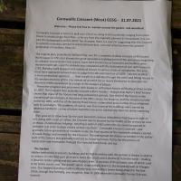
The Cornwallis House history page says:
In the early 20th century the house, together with Grove House, became a Catholic school, St Joseph’s High School for Girls. The Congregation of La Retraite took over the school in 1924, with the nuns living in Grove House while the schoolrooms were in Cornwallis House. The headmistress was Mother St Paul de la Croix (Sister Paula Yerby). By the 1970s La Retraite High School had around 700 pupils.
It closed in 1982 and the building was bought by Pearce Homes Ltd (now part of Crest Nicholson) who developed it into 21 flats. Grove House next door was bought by the Bristol Cancer Help Centre, and was later converted into flats in 2007.
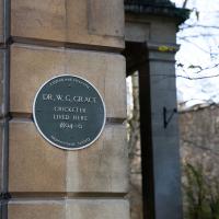
A formidably beardy cricketer of yore, widely considered one of the greatest players in history.