Tagged: n
Victoria Square Underpass
06 May 2021
I'm meant to be taking a little break from this project, but in my Victoria Square researches after my last walk I noticed a curiosity I wanted to investigate. The community layer on Know Your Place has a single photograph captioned, "The remains of an 'underpass' in Victoria Square".
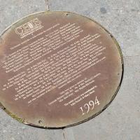
Looking back through the maps, I could see that there really did used to be an underpass across what used to be Birdcage Walk. I can only guess that it was there to join the two halves of the square's private garden that used to be separated by tall railings that were taken away during WWII. Maybe it was a landscaping curiosity, maybe it was just to save them having to un-lock and re-lock two gates and risk mixing with the hoi polloi on the public path in the middle...
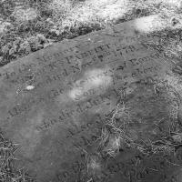
Anyway. Intrigued, I popped up to Clifton Village this lunchtime for a post-voting coffee, and on the way examined the remains of the underpass—still there, but only if you know what you're looking for, I'd say—and also visited a tiny little road with a cottage and a townhouse I'd never seen before, just off Clifton Hill, and got distracted by wandering the little garden with the war memorial in St Andrew's churchyard just because the gate happened to be open.
EDIT: Aha! Found this snippet when I was researching something completely different, of course. From the ever-helpful CHIS website:
When there were railings all round the garden and down the central path, in order that the children could play together in either garden there was a tunnel for them to go through. This was filled in during the 1970s but almost at the south east end of the path if one looks over the low wall the top of the arches can still be seen.
Tags: Bristol Places UK onemilematt united kingdom Clifton Village Saint Andrew's Churchard
Auto-Tags: Grey Grass Groundcover Font Grave Road surface Concrete Cemetery Monochrome photography Soil Monochrome Pattern Landscape Rock Circle
Text Recognition Tags: Nemery o PARFITT of n died Nov 1779. Ako to thc Memor Son of ho died L AlsoJ to D ARD Nemery o PARFITT of n died Nov 1779. Ako to thc Memor Son of ho died L AlsoJ to D ARD
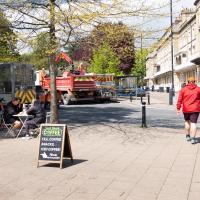
It's resurfacing season in Clifton, it seems. Certainly there've been a lot of cones and warning signs around the place.
Tags: Bristol Places UK onemilematt united kingdom Clifton Village
Auto-Tags: Wheel Plant Tire Vehicle Tree Road surface Infrastructure Asphalt Building Waste container Neighbourhood Urban design Shorts Waste containment Sidewalk
Text Recognition Tags: Casl n COFFEE TEA, COFFEE SNACKS ICED COFFEE Casl n COFFEE TEA, COFFEE SNACKS ICED COFFEE
Sequel Injection
07 May 2021
I saw this tweet the other day and started thinking of my second Covid-19 vaccination as my "Sequel Injection" (to a geek, it's funny. You'll have to take my word for it.) Whatever you call it, this morning I went and got it.
It was in the same place I got my initial injection—my left arm! No, okay, it was at the Clifton College Prep School. I didn't take any photos of the event itself; the NHS production line is so efficient you barely have time to do anything else, even if the privacy of other patients wasn't a factor.
Along the way I mused at all the road resurfacing going on in Clifton, and also discovered a secret (okay, not-well-known and possibly slightly trespassey) way into Canynge Square, and on the way back I knocked off a few streets from my "leftovers list" of north-east Clifton. I've got much of Clifton done now, with the only obvious "to dos" on the east side of Whiteladies Road...
It was quite a long walk, and I'm feeling pretty tired now, though that might be the effects of the jab too, I suppose. Anyway. Tomorrow and Monday I'm walking outside Bristol, I think, and I imagine my feet will need some recovery time on Sunday, so it might be a while before I post another Wander.
Tags: Bristol Places UK onemilematt united kingdom Clifton Village Clifton Clifton Suspension Bridge CHIS
Auto-Tags: Road surface Font Circle Public utility Concrete Number Metal Tar
Text Recognition Tags: CLIPTON& OWELLS The cty w k el rt n t of h Cie of Han Waler al. The L The Wall Charitahle Tr, We Baclays Ba yte CoopenLynd Engise Wloyen Wees A ichand DiC Ne Tou, Bde 4& Fatne L. Sion Brook ag Mr Ms J el & Mes Wia . MrA M ks d Nr.& M Jebhe Lydda. Mr. & M Crig Begg M. M Sephen Mactelne. MA Me. Per hem Mr. A M Pip Gray. Alder Me leis ac M MA Mn ay Tn, DEA Ms Montp b M. & Ms. las Fatkaer. Mdrk M Mche Pc De. Cone Ma Kenedy Dr. Mn. Setan Cebrwic The RL wia Waga MP.Pocia Cimacs a Adrian oes Anhiect, Mr.A Ms Smon Poller. M Roh tgec, Min. Py Ka lan Tharton lag. Mr & drs. David Mler, Mr. Mn Joho Chies M Mis. Caria C Mr. a Mes. Ssepben Thoas, Me. Mes Cesnlell Jenes. Mr. Me. Rager Sy. M Las anbey the Hewer Family, Mr. & M. Rusell Cun. M &. Cha Nanon, Mr. uba Ces Mis Geraldine Squise, the puis of Cios Colleg ad Ches He So and other meibers of the Clin coomity she generoly c foda di insaces. theie n la CH were gres in oemry of Gertrude Herses OBE. RA. Mz. & Ms. BertildA Labrie. Ms. Enid Dury Ms. Paytia Hsclanan The eatire projeci was coondinated bw Sobs Ressell & Mary Birch 1994 CLIPTON& OWELLS The cty w k el rt n t of h Cie of Han Waler al. The L The Wall Charitahle Tr, We Baclays Ba yte CoopenLynd Engise Wloyen Wees A ichand DiC Ne Tou, Bde 4& Fatne L. Sion Brook ag Mr Ms J el & Mes Wia . MrA M ks d Nr.& M Jebhe Lydda. Mr. & M Crig Begg M. M Sephen Mactelne. MA Me. Per hem Mr. A M Pip Gray. Alder Me leis ac M MA Mn ay Tn, DEA Ms Montp b M. & Ms. las Fatkaer. Mdrk M Mche Pc De. Cone Ma Kenedy Dr. Mn. Setan Cebrwic The RL wia Waga MP.Pocia Cimacs a Adrian oes Anhiect, Mr.A Ms Smon Poller. M Roh tgec, Min. Py Ka lan Tharton lag. Mr & drs. David Mler, Mr. Mn Joho Chies M Mis. Caria C Mr. a Mes. Ssepben Thoas, Me. Mes Cesnlell Jenes. Mr. Me. Rager Sy. M Las anbey the Hewer Family, Mr. & M. Rusell Cun. M &. Cha Nanon, Mr. uba Ces Mis Geraldine Squise, the puis of Cios Colleg ad Ches He So and other meibers of the Clin coomity she generoly c foda di insaces. theie n la CH were gres in oemry of Gertrude Herses OBE. RA. Mz. & Ms. BertildA Labrie. Ms. Enid Dury Ms. Paytia Hsclanan The eatire projeci was coondinated bw Sobs Ressell & Mary Birch 1994
Shop Fronts of Regent Street
22 May 2021
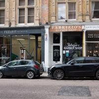
I didn't even think I'd manage to get out today, such was the weather forecast. As it turned out, it's been quite a nice day, and I managed to nip up to Clifton Village to pop to the Post Office. As with my last outing, I decided after snapping one shop-front on Regent Street that I might as well snap the whole row, and muse on a few of them, the only service I really offer over and above Google Street View for a lot of my pictures 😀
I have literally no idea what a "conscious apparel eco-fitness studio" is. It used to be Design Flooring, where I bought the oak flooring for my living room, a long time ago. It's lasted well.
The other two shops give an idea of the high concentration of hair salons in Clifton Village in general. I have little need of such establishments.
Tags: Bristol Places UK onemilematt united kingdom Clifton Village Clifton shops businesses shopfronts
Auto-Tags: Tire Wheel Car Land vehicle Vehicle Window Automotive parking light Building Automotive design Automotive lighting Automotive tire Motor vehicle Door Architecture Automotive exterior
Text Recognition Tags: FABRIZ IO'S HAIR SALON. BLOW DRY BAR BARHER SHOP FEELFIT THE CLIFTO N HAIR COMPANY Fabuizio's BARBER SHOP FABRIZ IO'S HAIR SALON. BLOW DRY BAR BARHER SHOP FEELFIT THE CLIFTO N HAIR COMPANY Fabuizio's BARBER SHOP
Coffee, Coronation and Clift House Road
28 May 2021
Another dash to Greville Smyth Park for a coffee from Rich at Hopper, but at least this time I managed to divert a bit and knock off a small section of Cumberland Road I'd managed to miss on previous excursions. Along the way I muse on a strange residence in between a warehouse and a tannery, and wonder if the Mayor might be deliberately letting the Cumberland Road Flyover area go to seed...
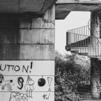
I composed a few photos to get the full length of wall in here. The whole of the Cumberland Road Flyover System is covered in tagging and graff at the moment; either it's really burst into life as pastime for bored youth since Covid or the council have given up on cleaning it up.
I suspect the latter—the more clapped-out and unattractive this bit of Hotwells is made to look, the more the Mayor can point at his pet Western Harbour project as an improvement.
Tags: Bristol Places UK onemilematt united kingdom Hotwells Cumberland Basin Flyover System plimsoll bridge
Auto-Tags: Handwriting Font Graffiti Gas Brickwork Writing Facade Tints and shades Brick Street art Building material Metal Fixture Signage Art
Text Recognition Tags: REOLUTIO N! Danin D GIVEanREACE ACHA NCE Fu Fu do LOVE ISTHE ANSWER の FITZY REOLUTIO N! Danin D GIVEanREACE ACHA NCE Fu Fu do LOVE ISTHE ANSWER の FITZY
Though originally it was a revAlution, it seems. I think they missed a chance to turn the "A" into the anarchy symbol, which would have styled it out nicely...
Tags: Bristol Places UK onemilematt united kingdom Hotwells Cumberland Basin Flyover System plimsoll bridge spiral staircase
Auto-Tags: Plant Photograph White Black Infrastructure Sky Black-and-white Style Wall Art Monochrome Facade Monochrome photography Font Urban area
Text Recognition Tags: REVELUTIO N! REVELUTIO N!
I managed to knock off a reasonable chunk of the roads I had left to walk around the University at the north-eastern extremity of my mile on this nice sunny walk. As well as being impressed by the number of big townhouses now occupied by various departments, I took some time on my way there to check out a war memorial, and some time on the way back to do a little extra wandering of Berkeley Square.
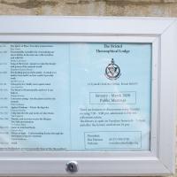
The Theosophical Society also lets its lodge be used by a variety of other organisations, including the Bristol Dowsers; a branch of Carlos Castaneda's Tensegrity folk (some of the videos of Tensegrity are quite something); a meditation group; and the local branch of the White Eagle Lodge, founded by a medium who received various teachings from the eponymous founder.
Given that those are the groups who openly practise there, I can only imagine the list of occult factions who use the rooms on other days...
Tags: Bristol Places UK onemilematt united kingdom Clifton Bristol Theosophical Lodge Theosophical Lodge theosophy
Auto-Tags: Rectangle Font Wood Commemorative plaque Landscape Symmetry History Memorial Public utility Circle Interior design
Text Recognition Tags: १८का Noy The Bristol Ihe Sprit at a Teabe ptia Theosophical Lodge ianer hatties becs vanale Sengtihe fesot-mt evkettee d prerd the rall Maten a Me mh Ihe bshng pewerthe id- det trdil d werk Taagrity orul adaat ind 14 Terudals Pukd. C. ri BS Y In kiry of lepale sad be January - March 2020 Public Meetings Mign e h Coesces catag -ke ptaette te Fe Ai d Wtheeg de l Acher Mad Adeiheld wel o Alke ley There are lectures or discuesionsaery Tday evening 70- 9:00 pm almisioe is te hit collectuns takem The libwary is open on Temdays Irom457m and after the lectune until about io pm. Mar un Te ed m thto Tee Tube tut Hes Oetinindan N enttigr t g kat he atda fne Prsident (OL17) 9047n5 www.beisthedodge ang Hei Hanon Webshe १८का Noy The Bristol Ihe Sprit at a Teabe ptia Theosophical Lodge ianer hatties becs vanale Sengtihe fesot-mt evkettee d prerd the rall Maten a Me mh Ihe bshng pewerthe id- det trdil d werk Taagrity orul adaat ind 14 Terudals Pukd. C. ri BS Y In kiry of lepale sad be January - March 2020 Public Meetings Mign e h Coesces catag -ke ptaette te Fe Ai d Wtheeg de l Acher Mad Adeiheld wel o Alke ley There are lectures or discuesionsaery Tday evening 70- 9:00 pm almisioe is te hit collectuns takem The libwary is open on Temdays Irom457m and after the lectune until about io pm. Mar un Te ed m thto Tee Tube tut Hes Oetinindan N enttigr t g kat he atda fne Prsident (OL17) 9047n5 www.beisthedodge ang Hei Hanon Webshe
Bank Holiday Street Art
31 May 2021
A nice warm Bank Holiday Monday saw me walk back over to Bedminster to do justice to something we glimpsed on my last wander. Along the way I spotted a couple of new pieces of street art tucked away on the south side of the Cumberland Basin Flyover system, so this turned into a micro-graffiti walk.
I love how three-dimensional the eyelids are.
Leigh Woods Solo
19 Jun 2021
I hadn't really planned to go out for a wander yesterday; I just got the urge and thought "why not?" (Well, the weather forecast was one possible reason, but I managed to avoid the rain, luckily.)
I wanted to finish off the A369—as it turns out I may still have a small section to go, but I've now walked the bulk of it out to my one-mile radius—and also a few random tracks in Leigh Woods. I'm still not really sure that I'm going to walk them all, especially after discovering today that "the map is not the territory" applies even more in the woods, where one of the marked tracks on the map wasn't really that recognisable as a track in real life... I'm glad I'd programmed the route into the GPS in advance!
Anyway. A pleasant enough walk, oddly bookended, photographically at least, by unusual vehicles. Leigh Woods was fairly busy, especially the section I'd chosen, which was positively dripping with teenage schoolkids with rah accents muttering opprobrium about the Duke of Edinburgh. I'm presuming the harsh remarks were more about taking part in his award scheme than the late Consort himself, but I didn't eavesdrop enough to be certain...
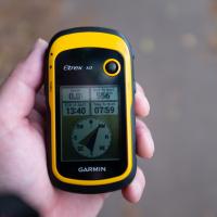
This is what I've been using to record the GPS track for all my walks. It's old-fashioned, but I find it more accurate than the phone, plus it runs off a couple of AA batteries and I only have to replace them every few weeks. Today it wasn't just recording my track, but also guiding me through a pre-planned route. Here it shows me direction, distance and estimated time to my next waypoint.
Tags: Bristol Places UK onemilematt united kingdom Abbots Leigh Road
Auto-Tags: Hand Measuring instrument Bicycle accessory Gadget Communication Device Recreation Portable communications device Running Display device Exercise Mobile phone Temperature Service Gps navigation device
Text Recognition Tags: etrex 10 lit to nat 0.0 556 ET at Dest Ta a et 13:40 07:59 N- GARMIN etrex 10 lit to nat 0.0 556 ET at Dest Ta a et 13:40 07:59 N- GARMIN
Shops, Hedgehogs and Cows
06 Jul 2021
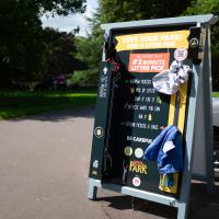
I really only took the GPS and camera on a "just in case" basis, as I knew I was only going for a coffee in Greville Smyth Park along a well-trodden path this lunchtime. Still, I saw a few new things along the way, so I figured it was worth uploading the handful of photos I took...
Tags: Bristol Places UK onemilematt united kingdom Bedminster Greville Smyth Park Ashton Gate
Auto-Tags: Tire Wheel Vehicle Automotive tire Motor vehicle Asphalt Automotive lighting Automotive design Tree Car Road surface Automotive exterior Gas Vehicle door Automotive wheel system
Text Recognition Tags: LOVE YOUR PARKI KEEP IT LITTER FREE # 2 MINUTE LITTER PICK IP LITER KDE WAT Y ON +N POERS 6 BMS BE CAREFUL PARK LOVE YOUR PARKI KEEP IT LITTER FREE # 2 MINUTE LITTER PICK IP LITER KDE WAT Y ON +N POERS 6 BMS BE CAREFUL PARK
Pastures New!
17 Jul 2021
Okay, not much in the way of actual pasture to be had in Bedminster these days, like most of Bristol, but I did take advantage of the current rather toasty weather in Bristol to go and sit under a tree in Greville Smyth Park to read a book for a while before firing up the GPS and taking a little detour around some back streets of Ashton and Bedminster rather than going straight to Coffee #1 for an espresso frappé. This is the first walk in a while where I've actually crossed off an entire new street (the frankly unexciting Carrington Road) as well as exploring a couple of back alleys, just because they were there, really. Along the way I spotted a few examples of graffiti of various qualities, including a live work-in-progress by SNUB23 on Ashton Road and the finished Six Sisters project on North Street.
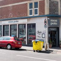
This Scandinavian design shop has replaced the Hobbs House Bakery Cafe. While I enjoy Scandinavian design, anyone who's looked at my interior design and then looked at my actual exterior can fairly swiftly work out that I enjoy bread rather more. Still, I can get my hands on a Sherston Overnight White (best loaf in the world for toasting, according to both Hobbs House and to me) elsewhere, and clearly Mon Pote needed the extra space—this location is four times the size of their previous one, which was also much further up the road.
Tags: Bristol Places UK onemilematt united kingdom shop Bedminster North Street
Auto-Tags: Car Wheel Automotive parking light Tire Land vehicle Vehicle Window Building Infrastructure Motor vehicle Waste container Door Sky Automotive exterior Road
Text Recognition Tags: mon mon pote pote n poto non pote TRU mon mon pote pote n poto non pote TRU
Green Squares and Secret Gardens
31 Jul 2021
At the end of July I went to have a look around some of the private gardens opened up by the annual Green Squares and Secret Gardens event. Sadly it was compressed into a single day this year, for various Covid-related reasons, it seems, so I didn't get to poke around too many places. I went to:
- A talk by the oldest resident of Victoria Square
- The St Vincent's Rocks Hotel garden
- The Paragon garden
- Cornwallis Crescent gardens, both east and west
- The Polygon garden
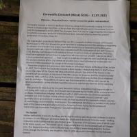
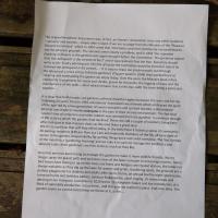
And snapped a few things in between, too. It was a lovely day—a bit too hot, if anything—and it was interesting to get into a few places I'd only ever seen from the outside, especially The Paragon and Cornwallis gardens, which are the least visible to passing strangers of all of them.
Tags: Bristol Places UK onemilematt united kingdom Clifton Village Clifton Cornwallis Crescent Garden Clifton Open Garden Squares Green Squares and Secret Gardens open day Cornwallis Crescent garden
Auto-Tags: Font Grass Wood Terrestrial plant Groundcover Grass family Plant Paper Commemorative plaque Rectangle Landscape Paper product Document Publication History
Text Recognition Tags: Cornwallis Crescent (West) G5SG - 31.07.2021 Welome-ease teel tree to wander round the garden and woodland Comwal Crescnta home to wel er 150 u. ng in 85 h holds cangng fromente huse to mesty sin oor tats-a larcry fron the originaly olanned 31 households Itnot at the demugraphi prute whch has changed, there na cane forsuggesting that the Crescent sureetly enjoyru a perod efunerecedemad ke, cae and attention fm the pret generation of reutents, Read o. The ongnal plan pronatly by AIta Pay as tor a mplete shullew cresmtol 4hes Work begat a1791, buc akeady the gret spetidative bukdng boo of the perkidwas beginnirg e colapie resaurs become scar, lons had to ome by as finwnciers and buiders were edered boninatnd the debide wan completed wiiti the decteration of war wth France in Bding work vtopped with i tal houne in vanous states of complenn The area inust have arpeaet etroordinary to ute hom this ommentaryof R07 1do noe ecalect mone melhoy oectace westem enros of ms citwamot avofuts are so none than a wok oea d dou t gh tre sent and folng nouses n andesd Theraher meal, with loass on unfinished hauses stit beng gramed an l The Cressent then proably enjoved a hart heydaythough Alan yder's briet testory shows that many f the houses had fong untannted periods dne thied of the houses in the wntern taif atood empty at the time of the I51 census for instance, and the stuation is itle better ty L89L with fiet of the twenty three houses untenarted ind a further thres inhabited only by cartaken The problem of coure was tht many of the buidings were owned hy sentee lindhordi-some of whom tad itle interest in mntaiing them let alone imeroving propress was pite them Nan goes on to show tw y the early twmtleth contury undatian hod beyan to rake to Ang with much of ctor the Cescnt was to beame by the middle of the cntury an anw d cheap maaned odgings reachng eadr in 136 tem he oty cdund proposed to demalah itin prer to bda block of huh-e Datir Comwalh Crescont survtaed-and gadualya nee gonration of residents mode the finsl uarter of the twentieth century perkod of rapid change and runewis for the Crescent. The widespread derekction so evident in the earker part of the oury was gradualy reversed an, house by house Hat ly fat the procs of restoration and renovation changed the Crescent boch inside and mut The Garden Hdden tehind the Crestent's buidings and thigh boundary wal, the gurden is aw a surpriee to wstars. it's the best part of an acre, faces dje south and is shettered from the north-making tideal for terder plants and sun warshippers alte It consists of three laur, two of witsch used to be terns courts and the woods whih slope steeply soun to the bundary wal on Polypon Lane. Our longmt-standing resident. Myrtle Way ememten ter beng played in the tne 1950, though less famaly, one imagines, than in 1906 when the Comwalts Tenni Clit wa fanned Cornwallis Crescent (West) G5SG - 31.07.2021 Welome-ease teel tree to wander round the garden and woodland Comwal Crescnta home to wel er 150 u. ng in 85 h holds cangng fromente huse to mesty sin oor tats-a larcry fron the originaly olanned 31 households Itnot at the demugraphi prute whch has changed, there na cane forsuggesting that the Crescent sureetly enjoyru a perod efunerecedemad ke, cae and attention fm the pret generation of reutents, Read o. The ongnal plan pronatly by AIta Pay as tor a mplete shullew cresmtol 4hes Work begat a1791, buc akeady the gret spetidative bukdng boo of the perkidwas beginnirg e colapie resaurs become scar, lons had to ome by as finwnciers and buiders were edered boninatnd the debide wan completed wiiti the decteration of war wth France in Bding work vtopped with i tal houne in vanous states of complenn The area inust have arpeaet etroordinary to ute hom this ommentaryof R07 1do noe ecalect mone melhoy oectace westem enros of ms citwamot avofuts are so none than a wok oea d dou t gh tre sent and folng nouses n andesd Theraher meal, with loass on unfinished hauses stit beng gramed an l The Cressent then proably enjoved a hart heydaythough Alan yder's briet testory shows that many f the houses had fong untannted periods dne thied of the houses in the wntern taif atood empty at the time of the I51 census for instance, and the stuation is itle better ty L89L with fiet of the twenty three houses untenarted ind a further thres inhabited only by cartaken The problem of coure was tht many of the buidings were owned hy sentee lindhordi-some of whom tad itle interest in mntaiing them let alone imeroving propress was pite them Nan goes on to show tw y the early twmtleth contury undatian hod beyan to rake to Ang with much of ctor the Cescnt was to beame by the middle of the cntury an anw d cheap maaned odgings reachng eadr in 136 tem he oty cdund proposed to demalah itin prer to bda block of huh-e Datir Comwalh Crescont survtaed-and gadualya nee gonration of residents mode the finsl uarter of the twentieth century perkod of rapid change and runewis for the Crescent. The widespread derekction so evident in the earker part of the oury was gradualy reversed an, house by house Hat ly fat the procs of restoration and renovation changed the Crescent boch inside and mut The Garden Hdden tehind the Crestent's buidings and thigh boundary wal, the gurden is aw a surpriee to wstars. it's the best part of an acre, faces dje south and is shettered from the north-making tideal for terder plants and sun warshippers alte It consists of three laur, two of witsch used to be terns courts and the woods whih slope steeply soun to the bundary wal on Polypon Lane. Our longmt-standing resident. Myrtle Way ememten ter beng played in the tne 1950, though less famaly, one imagines, than in 1906 when the Comwalts Tenni Clit wa fanned
Tags: Bristol Places UK onemilematt united kingdom Clifton Village Clifton Cornwallis Crescent Garden Clifton Open Garden Squares Green Squares and Secret Gardens open day Cornwallis Crescent garden
Auto-Tags: Plant Grass Wood Font Rectangle Groundcover Terrestrial plant Grass family Commemorative plaque Paper Paper product Landscape Publication Document Pattern
Text Recognition Tags: Alhe ongeat Besdents Asooatten w n tact an Ownery Asoction n uy otheresidents sarvants and tnantamply datn'tcourt,ifwe are to jutge buan the Minuts of the eaure Ground Commttue whch in 1904 voted that taretoes and mer faes be et permitted to ae he plrae ground The ervants were dearly a problem, and in 12 e evatad alwng of Mers in the gendens s ogin droughta that he delinguents the ernt ot No2and t waireoked at the on Secnetany should wite to Mr. Esery ponting ut the e of actithe Canmitee eulbe forct to nahe reted the einquit n Ais aniceIta ey to beas ur predeeos but through the laboun of anore ar less ful-ine gadener e per wkin 18 they worted hard at cresting and mantaning the ganden we njny tody. Over the pears the Minutes book refers constantly to payments for eeh and shut, andtor the paths the lopping oftand the manteriance of the was-al of whah remainstnie ti day with the tres being partieular thefore he Camtt The gardemer tate tio epee It clear that toth heuses and gandes uffered dre eet setwthe as and for the folkowng 20 ywars Then in 1963 a Residents Aocutun was farmed whech emtraed the sgir af the age led by anewneration of owner aupies.and spitad tenantsa deteined attempe as made to mole etryane in the care of their haned anironmant The fact that eerol taf serp undanter rub ws of the state to which the prdns had deckned. There are stl a couple of ndents iing hers who took part in that massive dea e Weowe them agrst e We try to contue that self ep echos today, in the bellef that z fosters a samn of community All ptup residents er fleer paare tomatkally memters of the RA all havenght of acs to the garden Reponshlky for geting things done rests with everoe. The firat Sunda of she month is a'gandening elorning and we takein tus to mange the rkforce and alleate tasks. Keen gardeners are free moved d from the gardets is exidence enough s as much as they ke. Becently we haive been trying te manage he ganden to make mare wlfe frendly. We no Inngor spray the gravel path and we leave areasf the lawn unmwn to amcurage inects Some bird boons have teen pi u on the trees and Soses and badgers ane regar viston the latter not slwy welcome as they dig up the lan for wonms and gns dandeningrt, the grounds anea perfact plavaruund for chiidren and aduts ae de foctie, an anal bonfenight sctacule treasure hunts and bithday partiem, outdonr Shakeprare, carol singing sit doun meaand dancing in ourmarquee Lockdown in 2020 led to Cuckinghan Palace and the intraduction ofs fock of splenddy productive rescue hers, and this ar we started to plane truit ree aey The parden seemi to survive everything we thew t it, se far Alhe ongeat Besdents Asooatten w n tact an Ownery Asoction n uy otheresidents sarvants and tnantamply datn'tcourt,ifwe are to jutge buan the Minuts of the eaure Ground Commttue whch in 1904 voted that taretoes and mer faes be et permitted to ae he plrae ground The ervants were dearly a problem, and in 12 e evatad alwng of Mers in the gendens s ogin droughta that he delinguents the ernt ot No2and t waireoked at the on Secnetany should wite to Mr. Esery ponting ut the e of actithe Canmitee eulbe forct to nahe reted the einquit n Ais aniceIta ey to beas ur predeeos but through the laboun of anore ar less ful-ine gadener e per wkin 18 they worted hard at cresting and mantaning the ganden we njny tody. Over the pears the Minutes book refers constantly to payments for eeh and shut, andtor the paths the lopping oftand the manteriance of the was-al of whah remainstnie ti day with the tres being partieular thefore he Camtt The gardemer tate tio epee It clear that toth heuses and gandes uffered dre eet setwthe as and for the folkowng 20 ywars Then in 1963 a Residents Aocutun was farmed whech emtraed the sgir af the age led by anewneration of owner aupies.and spitad tenantsa deteined attempe as made to mole etryane in the care of their haned anironmant The fact that eerol taf serp undanter rub ws of the state to which the prdns had deckned. There are stl a couple of ndents iing hers who took part in that massive dea e Weowe them agrst e We try to contue that self ep echos today, in the bellef that z fosters a samn of community All ptup residents er fleer paare tomatkally memters of the RA all havenght of acs to the garden Reponshlky for geting things done rests with everoe. The firat Sunda of she month is a'gandening elorning and we takein tus to mange the rkforce and alleate tasks. Keen gardeners are free moved d from the gardets is exidence enough s as much as they ke. Becently we haive been trying te manage he ganden to make mare wlfe frendly. We no Inngor spray the gravel path and we leave areasf the lawn unmwn to amcurage inects Some bird boons have teen pi u on the trees and Soses and badgers ane regar viston the latter not slwy welcome as they dig up the lan for wonms and gns dandeningrt, the grounds anea perfact plavaruund for chiidren and aduts ae de foctie, an anal bonfenight sctacule treasure hunts and bithday partiem, outdonr Shakeprare, carol singing sit doun meaand dancing in ourmarquee Lockdown in 2020 led to Cuckinghan Palace and the intraduction ofs fock of splenddy productive rescue hers, and this ar we started to plane truit ree aey The parden seemi to survive everything we thew t it, se far
