Tagged: at
Rainy Clifton
13 Dec 2020
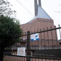
A long walk around Cliftonwood and Clifton with my friend Lisa, taking in some of the 12 Days of Christmas display at Queens Parade, picking up a take-away coffee from Pinkmans of Park Street, and poking our heads up against the glass of SS Peter and Paul Catholic Cathedral.
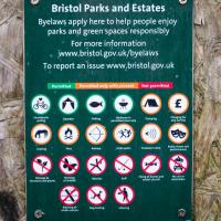
We wondered how often someone applied for consent to perform Archery on Brandon Hill.
I went to have a peep at the giant sinkhole that's opened up in Canynge Square—ironically, having recently discovered the gardens were public I'd had the (triangular!) square on my list to re-visit for a few days, but now there's no entrance to the gardens due to the danger. The area was well fenced-off for safety, but I tried to get a couple of photos from behind the barriers.
I also explored the area around Camp Road, an real melange of architectures, one of the most mixed-up areas I've seen in Clifton, in fact, and confirmed my friend Claire's suspicion that an earlier snap of a sign from Manilla Road was in fact for a fire hydrant. Nice.

Saint Vincent's Spring
28 Dec 2020
Fractionally outside my one-mile zone, but I got curious about Saint Vincent's spring, whose last remnants you can see in a defunct drinking fountain on the Portway. Along the way I passed Gyston's cave, sometimes called St Vincent's cave, in the sheer wall of the gorge. It's now accessible by a tunnel from the observatory—I tried it about twenty years ago, I think, and still recall the vertiginous moment of looking down from the protruding balcony and realising that you could see straight through the grille floor to the drop below—but from what I can work out the tunnel is relatively recent. Before the tunnel was dug it was accessible only by access across the cliff face, which must have been even more terrifying.
This cave was first mentioned as being a chapel in the year AD 305 and excavations, in which Romano-British pottery has been found, have revealed that it has been both a holy place and a place of refuge at various times in its history.
A few different sources say that the cave became a hermitage and chapel to St Vincent following Bristol's early trading in Iberian wines; St Vincent of Saragossa is Lisbon's patron saint, and a lot of nearby things bear the name.
I'm not sure where the crossover of Vincent and Ghyston happens, though. On the giants Goram and Vincent (or Ghyston), Wikipedia says:
The name Vincent for one of the giants rests on the fact that at Clifton, at the narrowest point of the Avon Gorge, there was formerly an ancient hermitage and chapel dedicated to St Vincent, at or near the present cave in the cliff-face which bears his name. Another (apparently modern) version of the story calls the Clifton giant Ghyston, which is in fact the name, of obscure origin, for the whole of the cliff-face of the Avon Gorge at least as early as the mid-fifteenth century, in the detailed description of the Bristol area by William Worcestre. The place-name was personified to produce the giant's name. Vincent's Cave is called Ghyston cave or The Giant’s Hole in an article in the July 1837 issue of Felix Farley’s Bristol Journal.
In my research on the original Hot Well House, I've seen quite a few contemporary paintings which state their viewpoint as "from St. Vincent's Rock", so in the 16th century it seems the cliff-face name was typically St Vincent Rock rather than Ghyston's Rock, perhaps.
I am, as you can tell, no historian!
On the way, I also wandered around the base of the popular climbing area, which I think is the site of the old Black Rock quarry.
Northern Clifton
16 Jan 2021
A raggedy wander with my friend Lisa, picking up a few stray streets and venturing only briefly onto Whiteladies Road, where it was too damn busy, given the current pandemic. We retreated fairly quickly. Found a couple of interesting back alleys, and got a very pointed "can I help you?" from a man who was working in his garage in one of the rather run-down garage areas behind some posh houses, and clearly didn't want us just wandering around there.
In Between
06 Feb 2021
A lovely walk in the early spring sunshine with my friend Lisa. We headed directly for Jacobs Wells Road, to start off around the scene of one of our earlier walks, but this time took in Jacobs Wells from QEH upward, stopping to snap some photos of a Bear With Me, some interesting areas between Park Street and Brandon Hill including a peculiarly quiet enclave with a ruined old build I'd never found before, then crossed the Centre to grab take-away pies from Pieminister (I had the Heidi Pie) and head back to my place down the harbourside.
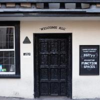
There's a longstanding rumour that under all that black paint, the door is lined with human skin. Nobody seems to know where this story originated.
Arlington Villas and WH Smith Destruction
10 Feb 2021
I actually dashed up to Clifton to take a look at Arlington Villas, just around the back of St Paul's Road, one of those slightly odd little enclaves of overlooked housing that you know is there, but you never have a reason to visit or travel down. As it turned out, interesting though the (public) garden is, I actually took far more pictures of the now-completely-demolished site bounded by King's Road, Boyce's Avenue and Clifton Down Road where WH Smith and other places used to stand.
It's interesting to imagine how nice this little area would be if turned into a permanent public square, but of course the developers already have their planning permission to build it right back up again.
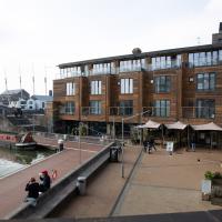
Harbour Circumnavigation
01 Mar 2021
Normally I don't have enough time in my lunch hour to get all the way around the harbourside. This is a shame, as Wapping Wharf is a great place to get coffee and a snack, but it's pretty much diametrically (perimetrically?) opposite me on the harbour. Today I had the day off, so I decided to go and knock off a few streets around Anchor Road that I'd not covered, as well as visiting the site of the Read Dispensary (well, one of them) and dropping into Mokoko for one of their astounding almond croissants. From there I came back along the south side, checking out the views from as much of the Chocolate Path as you can venture down at the moment, and swapping from Cumberland Road to Coronation Road at Vauxhall Bridge.
There's a lot of meh photos on this walk—my chief output from this project could be politely described as "record shots"—but a few turned out well, especially those of Vauxhall Bridge from the Chocolate Path, which reminded me how much of a loss the current closure of the Chocolate Path is to walkers and cyclists in Bristol.
Broken Dock is the name of one of the restaurants down there, but also seems to be the name for this little harbour inlet in general, if the Bristol Post's many articles about how people keep gathering in illegally large numbers here are anything to go by. The local residents seem a bit fed up with everyone piling up here and then going to the loo all over the place because there aren't any toilets open anywhere due to the pandemic. Nice. It was fairly quiet on this weekday afternoon, which is why I chose today for a round-the-harbourside walk.
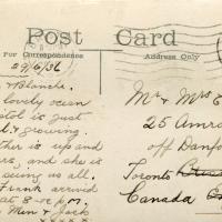
I bought a vintage post card from eBay this week. It's a well-known photo of the Hotwells landing stage, showing what's likely to be a P&A Campbell paddle steamer moored there. (Just yesterday I snapped a photo of their buoy on display at Underfall Yard with its information sign.) It was posted from here to Canada in 1936, and has now returned via a presumably quite circuitous route.
Local journalist Maurice Fells (really local—I could probably hit his house with a well-flung teacake from here) notes in The A-Z of Curious Bristol (£) that:
For tens of thousands of people, the pier at Hotwells was the starting point of their day trip as they boarded steamers with names like Glen Avon, Glen Usk and Britannia. The salty tang of the sea was never far away as the steamers headed for Ilfracombe, Weston-super-Mare, Clevedon and Portishead on the Devon and Somerset coast and Barry, Porthcawl and Tenby in South Wales.
The landing stage is long-abandoned. A variety of economic issues, including fuel prices, the increasing prevalence of the motor car, the construction of the Severn Crossing giving easier access to Wales, and the collapse of Clevedon Pier during safety testing in 1970, which prevented larger pleasure boats from stopping at the resort, all led to dwindling trade.
I went to have a poke about there today, not staying for long as it's a cold day and the wind was biting. I couldn't reproduce the postcard's view—you'd need to risk life, limb and presumably a trespass prosecution—but I did try to judge the rough viewpoint and angle of the photo by lining up with Rock House, the Colonnade and the Suspension Bridge and snapped a photo looking back to where the original photographer would have stood on the pontoon.
This Bristol City Docks history page has many good photos of the landing stage and the nearby Port and Pier Railway line (whose tunnel I was in the other day) and the Hotwells Halt railway station, which was just the other side of the suspension bridge from here.
I headed to Bedminster to do a crossword with my support bubble today. On the way I delved into a couple of bits of Hotwells history, first of all snapping a "now" shot to go with a historical photo of Holy Trinity I happened across recently, and second of all to snap the Britannia Buildings.
The Britannia Buildings are a little strip of offices on a corner of the Hotwell Road. They've mostly been the headquarters of a cleaning company for years, but I've often wondered what this distinctive curve of offices, its ground floor standing proudly out from the upper floors, used to be. Well, after my last wander, where I poked about the landing stage just down the road, I found out! Researching the paddleboat company P&A Campbell I came across this nugget in The A-Z of Curious Bristol, by Maurice Fells (£):
The firm of P & A Campbell was the main steamer operator in the Bristol Channel, with its local headquarters in offices close to the Hotwells pier and overlooking the harbour at the Cumberland Basin. Campbell's named their offices Britannia Buildings, after one of the ships in their White Funnel Fleet.
So! Turns out the Britannia Buildings were named after a paddle steamer—you can see some pictures of Britannia here.
In related news, I've now bought three of Maurice Fells' local history books, and they were hand-delivered by the author on Sunday, a half-hour after I ordered them online (through a message exchange on Nextdoor!) Not even Amazon Prime has managed to deliver me anything that quickly...
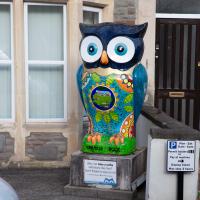
"I'd like to buy an owl, please." "We don't sell owls." "Someone told me you did." "Who?" "See! I just heard one!"
Since setting up a search for Hotwells on eBay I've mostly managed to restrain myself from buying much (or in one case, was outbid, luckily for my finances.) However, I couldn't resist a 1902 flyer for a singalong at the Terrett Memorial Hall, which would have stood five minutes' walk from my flat, overlooking Howard's Lock.
I've found out a fair bit about this non-denominational seaman's mission, including tracking down both a Loxton drawing and an aerial photo of it. The main thing that's eluded me, ironically enough, is finding out who Terrett was, so as a Memorial Hall it didn't do a very good job 😀.
EDIT: Ah! Did a little more digging and found that the Bristol Archives has a Bristol Dock Company document on file called "William Terrett, Esq.; corresp. etc. re proposed erection of a Mission Hall at Cumberland Basin, 1892", so that might be worth a look once the Archives are properly open again. Given that:
Sarah Terrett died suddenly on 25 November 1889, aged 53, after speaking at a meeting of the White Ribbon Army, the temperance organization she had founded in 1878. Following her death many people sent letters of sympathy to her bereaved husband, William. One of these, from the Rev. W. F. James, a minister of the Bible Christians, makes for especially interesting reading. The Bible Christian denomination, to which Sarah and William belonged, was one of the smaller Methodist connexions, and had its heartland in rural Devon, the area where she had grown up. James recalled the hospitality he enjoyed when visiting the Terretts’ home, Church House, in Bedminster, south Bristol...
...I wonder if William Terrett built the hall in memory of his late wife. They were clearly just the kind of temperance movement people who would've founded a seaman's mission to get people together to have a nice non-alcoholic singsong rather than a night out on the tiles.
Anyway. This walk to grab a coffee from Hopper Coffee in Greville Smyth Park was mostly an excuse to post the leaflet, a few other things I found related to it, and some pictures of how the site looks now. I would suggest that the present day is not an improvement.
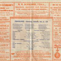
I find the adverts fascinating. My first optician in Bristol was Dunscombe's on St Augustine's Parade, so they were there a long time. They've closed now (or at least moved) but were still there as recently as 2008, I think. Interesting to see gas lighting systems being advertised, too!